| Area: Chinook Pass |
Hike Type: Family-friendly | Pass: No Pass Req |
| Distance: 5.4 mi RT | Duration: 2-3 hrs | Difficulty Level: Easy |
| Elevation Start: 2,670 | Elevation End: 3,385 | Elevation Gain: 715 |
| Snow-Free: Mid-May – Oct |
-
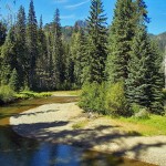
- a American River is lazy

-
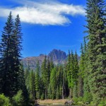
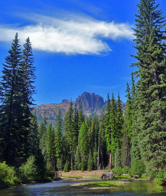
- d view of Fifes Peaks from the trail
-

- c frog

The Pleasant Valley Loop trail is a quiet, mostly forested hike; pleasant with gentle ups and downs. Views of the American River are numerous and several places offer spots to stop and dip your toes. As we hiked we felt the poignancy of the seasonal transition from summer to fall – the flowers are spent and the leaves of vanilla leaf mottled with age and streaked with gold.
There are several approaches to the Pleasant Valley Loop but we opted to start from the Hells Crossing trailhead about 13 miles east of Chinook. Given time constraints we knew there was not time to hike the full loop so we established a turnaround time hoping we could get to a trail junction at 2.7 miles – or even better, cross the river on a bridge and hike back to SR 410 not far from Hells Crossing.
We enjoyed views of the American River at several points along the trail; boot paths lead down for closer looks or on a warm day, wading in the river or just soaking up the sun. In early fall the American River runs lazy and slow; such laziness is contagious as we felt no need to hurry. There are also trout in the river – see fishing regulations per the Department of Fish and Wildlife. The river is shallow in places and given the late afternoon light and slant of sun, the river was a luminous blue-green and clear enough you could see down into the bottom. Sprawling river bars on the other side of the river were being utilized as they should be – there we saw a few folks just hanging out, enjoying the sun. In such a setting this is a place to be, not to do.
Then we saw the anthills. At first we thought they were mounds of earth but on second look we saw the surface of these mounds appeared to be moving. Further research after the hike enlightened us – these are apparently “thatch” ants and one of the things they like to eat is spruce budworms (this is good since spruce budworms are responsible for killing forests). Our macro-lenses were not macro enough for a good photo of ants but the mounds were 3-4 feet high and hard to miss. We marveled at the cooperation of ants, organized well enough to create and maintain such a structure; each ant knowing its place in the Grand Scheme.
After watching the ants go about their project we continued our hike. Past the ant hills, the trail alternates between more river views and forest; at about two miles passes what appears to be a primitive campsite before coming to a boggy area near a small stream that has gone nearly dry.
Not far from the boggy stretch we spotted an obvious trail heading down to the river and thought that might be where to cross (that is apparently the horse-ford), however, it’s not a hiker-crossing unless prepared to wade. Since we didn’t feel like wading we walked along the river and though we found no sign of a bridge or trail, we did find a frog and a fisherman’s path along the river that was well-worth pursuing. The path led to a bend in the river where Fifes Peak was reflected in the still water, a beautiful and tranquil scene.
Back on the main trail, we hiked a little further until we came to the trail junction shown on the map; here, Trail No. 958B heads to Pleasant Valley Lake and American Ridge; regrettably, we needed to turn around and head back for the day.
To complete the loop continue west (right) at the junction (Trail No. 958B) for another 4.3 miles, then cross SR 410 and hike (east) back to Hells Crossing (about 6-1/2 miles). The trail parallels SR 410, rest assured you are not hiking on the actual highway.
According to the Okanogan-Wenatchee Forest website (Naches District), the trail is closed at Pinus Creek – it’s missing a bridge – that’s not a problem for hikers this time of year but it could be for skiers as the Pleasant Valley Loop is also a cross-country ski trail (Pinus Creek is on the north side of 410 less than a mile west from Hells Crossing Campground). Until fall storms arrive and rivers grow treacherous; a look at the map will reveal potential loops and one-way hikes with a car-shuttle for hikers willing to explore.
Some hikers might find this trail a little on the tame side but we can vouch that no trail is dull; no matter how quiet a trail is, there’s always a surprise – an unexpected flower or view, perhaps a spotted frog, a glimpse of wildlife or even the warm weight of silence resting like the arm of a companion around your shoulders.
To get to Hells Crossing trailhead: Coming from Enumclaw drive to Chinook Pass on State Route 410, continue east approximately 13 miles to just west of milepost 84. Hells Crossing is on the right-hand side of the highway. A Northwest Forest Pass is not required at this trailhead.
Notes: There are several trailheads for the Pleasant Valley Trail; see map. Map: Green Trails No. 271, Bumping Lake, WA. Most trailheads have parking available for horse trailers as well as passenger cars. Some trailheads require a Northwest Forest Pass, some don’t. Carry one to be on the safe side if you want to access the trail from another trailhead. It’s also the time of year hikers need to know when the hunting season opens (dates vary from region to region). If in doubt, wear orange.
For additional information on fishing and/or hunting regulations contact the Naches Ranger District at 509-653-1401. To find out fishing regulations contact the Washington Department of Fish and Wildlife at www.wdfw.wa.gov
– Karen Sykes, Visit Rainier Hiking Expert
Waypoints
| Starting Point: 46.96473,-121.26612999999998 | |
| Notable Waypoints:
Trailhead at Hells Crossing: N 46° 57′ 53, W 121° 15′ 58 |
|