Mount Rainier’s Waterfalls
Mount Rainier’s waterfalls are not only thrilling to see, but can also tell stories of the park’s history and the natural forces that shape the area. Discover the park’s beautiful waterfalls and see why this mountain range is named “The Cascades.”
Whether it’s an exuberant cascade of water bouncing down a hillside, a sheet of glittering drops fanning across a rock face, or a tall “bridal veil” plunging down a cliff, each of Mount Rainier’s many waterfalls is uniquely beautiful.
The falls you see have been sculpted by the forces of water, ice, and volcanic fires. The mountain captures moist air moving inland from the Pacific Ocean, bringing abundant rain to fill the mountain’s streams and snow that will release water throughout the summer. In early summer melting snow fills the park’s streams and produces showy displays of dancing water throughout the park, to the delight of waterfall lovers and photographers.
tain captures moist air moving inland from the Pacific Ocean, bringing abundant rain to fill the mountain’s streams and snow that will release water throughout the summer. In early summer melting snow fills the park’s streams and produces showy displays of dancing water throughout the park, to the delight of waterfall lovers and photographers.
Use caution near streams and waterfalls, especially with children and when taking photographs. Always stay on marked trails and within safety barriers. Because stream banks and their plants are vulnerable to damage from foot traffic, it’s important to avoid trampling these fragile areas. Help preserve the beauty of Mount Rainier’s waterfalls for future visitors to enjoy.
Discovery #1 Christine and Comet Falls
Named after Christine Van Trump, daughter of one of the first climbers of Mount Rainier, these falls plummet down a rock cleft beside the road from Longmire to Paradise. A short trail leads you below the road for a view of the entire falls framed by the rock bridge. Beware of traffic on this road curve! The wooden bridge seen above the falls can be accessed by a trail leading from the parking lot 0.2 miles west of the falls. This trail becomes steep and rocky as it climbs to 320-foot Comet Falls (3.6 miles roundtrip, 1600 feet elevation gain, limited parking).
Quest-ion: What is the name of the stream feeding the falls? (Hint: Check the park map.)
Discovery #2 Narada Falls
Narada Falls are created by a 168-foot drop in the beautiful Paradise River. You can view the top from the edge of the parking lot, or take the short but steep trail to viewpoints below. These viewpoints let you see layers of wrinkled lava rock formed by past volcanic eruptions. Be prepared for refreshing sprays when the falls are at their peak!)
Quest-ion: What gouged out this deep canyon? (Hint: Check the sign along the viewpoint trail.)
Discovery #3 Myrtle and Sluiskin Falls
At Paradise, you may be able to look up across the Inn to see Sluiskin Falls (also visible from the western edge of the Visitor center parking lot). It is named after the Indian guide who assisted the first recorded climb to the summit in 1870. To walk to Myrtle Falls, turn right at the top of the trailhead steps by the visitor center and take the paved Skyline Trail a half-mile to Myrtle Falls, which may also give you good views of the mountain summit. Above the falls, a short side trail leads you down steps to views of the lower falls. Be sure to stay on the paved trail to avoid damaging this fragile area. In the summer you can join a ranger-guided walk here to learn about the beautiful wildflower meadows.
Quest activity: See if you can spot pictures of Myrtle Falls in the visitor center or gift store—it’s one of the most-photographed scenes in the park! Use the “passport” stamp at the visitor center’s information desk to stamp the date here:
Discovery #4 Stevens Canyon
Watch for waterfalls as you drive along Stevens Canyon Road: Sunbeam Falls just east of Lake Louise, Martha and Maple Falls across Stevens Canyon, and a number of smaller, unnamed falls (some almost spray your car at certain times of the year!)
Quest-ion: How many falls can you count as you drive along Stevens Canyon Road?
Discovery #5 Falls Creek Falls
Falls Creek Falls, just west of The Grove of the Patriarchs parking area, offer close-up viewing. In fact, they sometimes splash across the road during the peak run-off season! At other times, a sparkling curtain of droplets dances down the rock face.
Quest-ion: How would you describe the sound of these falls?
Discovery #6 Silver Falls
At Silver Falls the crystal-clear Ohanapecosh River plunges 75 feet to form a wide “block” waterfall before entering a narrow slot canyon under the viewing bridge. You can hike to the falls along a half-mile trail that starts across the road from the parking lot for The Grove of the Patriarchs. Or take a 1.5-mile trail from the Ohanapecosh campground and visitor center. You can also view the river by driving to the bridge in the Ohanapecosh Campground. Notice how the river’s rushing water has smoothed and shaped the surrounding rocks over time—some of the most ancient rocks in the park.
Quest-ion: What is the name of a very famous eastern North American waterfall that is also a block fall?
—
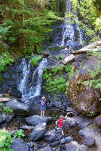
Photo courtesy Anna Robertson
There are over 20 kid-friendly places to stay nearby. For family-friendly lodging options in the Mt. Rainier area click here. And be sure to check out our family edition vacation planners, these free magazine style travel guides features trip tips, restaurants, activities, and attractions you won’t want to miss.