| Area: White Pass |
Hike Type: Overnight | Pass: William O. Douglas Wilderness Overnight
Permits required; free, self-issued at the trailhead |
| Distance: 11.9 mi loop | Duration: 2 days | Difficulty Level: Overnight |
| Elevation Start: 2,920 | Elevation End: 4,920 | Elevation Gain: 2,000 |
| Snow-Free: July – Oct |
-

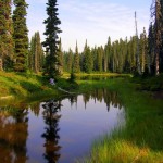
- frying pan lake3

-
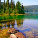
- frying pan lake2

-
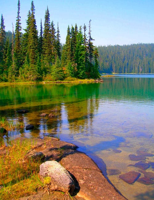
- frying pan lake4
Sitting in the heart of the William O Douglas Wilderness, in the midst of lake country, a backpack trip to Fryingpan Lake makes for an ideal location to set up camp for exploring other lakes and nearby peaks. This trek is both dog-friendly and kid-friendly and is also an excellent option for beginning backpackers.
The William O Douglas Wilderness lies just to the east of Mount Rainier National Park, covering over 160,000 acres of spectacular backcountry from the Cascade Crest to the arid foothills surrounding Rattlesnake Creek. Much of the “William O” consists of pumice flats dotted with ancient cinder cone volcanoes and speckled with hundreds of small lakes. It’s within those water-logged flats that hikers will find a gentle landscape of wildflower meadows and unlimited camping opportunities.
As mentioned, the hike to Fryingpan Lake is dog-friendly and gentle enough for children and beginning backpackers too; however, a few advisories must be noted. With so many bodies of water-many of them shallow-mosquitoes can be ruthless in this wilderness area. Autumn is a much better time to visit, but be aware that the region’s abundant elk herd attracts plenty of hunters. Be sure to wear orange. The area also attracts a fair amount of equestrian use, so be prepared to share the trails with horses. The most direct way to Fryingpan Lake (the return leg of the hike described here) is about 5 miles. But consider this loop for variation adding just a few more miles, but no extra elevation gain.
Starting from the Soda Spring Campground, follow the Cowlitz Trail which traces part of a historic route across the Cascades used by the Yakama and Cowlitz Peoples. Immediately enter the William O Douglas Wilderness, named for Yakima favorite son, William O Douglas who served on the US Supreme Court for over 36 years-the longest-serving justice in history. A champion of the environment, Douglas also spent many days roaming this high country now named in his honor.
After a half mile, come to a junction with the horse access trail. The tread from this point tends to get dusty and rocky in sections, but shouldn’t pose too many problems. What may be problematic however are the old trails and social trails diverting from the main trail. Pay close attention to junctions and have your map at the ready. The trail gently climbs following along Summit Creek through beautiful old-growth forest crossing many side creeks (often dry) along the way. At 2.2 miles reach a junction with the Jug Lake Trail. Continue right (unless your sole objective is to get to Fryingpan Lake the shortest way possible), you’ll be returning on the trail left.
Continue ascending, traversing slopes adorned in showy bear grass. The forest soon transitions to mountain hemlock and yellow cedar. Gaps in the forest canopy reveal surrounding ridges. At 3.7 miles just after passing a small cascade, reach another junction. The Cowlitz Trail continues right for 1.5 miles to the Pacific Crest Trail passing Penoyer Lake en route. The Crossover Trail head left back towards Jug Lake. Take the Pothole Trail which diverges from the junction straight ahead.
Now on a trail that sees less horse traffic, enjoy decent tread on a near level course across huckleberry patches and fields of heather and lupine. The way skirts numerous pothole ponds where there is always a good chance of spotting birds and other wildlife. Campsites can be found along the way. At about 4.5 miles, come to a long shallow nameless lake (el. 4,920-feet) with good camps to its north.
The enjoyable trail eventually reaches the Pacific Crest Trail (PCT). From this point, you have traveled 5.0 miles. The recommended loop to Fryingpan Lake continues north along the PCT-but consider a side trip right to two of the largest and nicest lakes in the vicinity, the Twin Sisters Lakes. To reach them, follow the PCT right for .1 mile, and then head left on the Twin Sisters Trail. After hiking 1.2 miles on this trail passing many small potholes ponds, reach the larger of the gorgeous Twin Sisters Lakes (el. 5,170 feet). A side path heads left to excellent campsites, lakeside ledges and inviting beaches. The smaller lake can be reached by continuing right another 0.6 miles.
To continue to Fryingpan Lake, follow the PCT north (left) for 1.1 miles to the Jug Lake Trail. Head south (left) on this good trail traversing groves of old-growth forest. After 0.6 miles, come to a junction with the Kincaid Trail. A good side trip is to follow this trail for 1.0 mile climbing steeply up 5,700-plus foot Fryingpan Mountain for some excellent views. Fryingpan Lake (el. 4,815-feet) lies just 0.2 miles from the junction. Surrounded by sprawling meadows, many good campsites can be found along the meadows’ forested edges.
Spend one or several nights at this good size lake and perhaps you’ll see or hear elk. Make side trips to other lakes and surrounding peaks, or just sit by the lake relaxing and soaking up the serenity of the backcountry. When you are ready to head back to the trailhead, continue south on the Jug Lake Trail skirting Snow Lake on the right and an unnamed lake on the left. Then descend via long switchbacks coming to a junction 1.4 miles from Fryingpan Lake. Left follows the Crossover Trail back to a familiar junction with the Cowlitz Trail. Continue right and in .4 mile come to another junction. If you want to check out Jug Lake, it can be reached by hiking right a mere.1 mile. Good camps can be found in shoreline old-growth groves.
To finish the loop and get back to your vehicle, head left. After a short climb, rapidly descend reaching the Cowlitz Trail in 1.0 mile. Turn right and return to the trailhead after retracing 2.2 familiar miles.
William O. Douglas Wilderness Overnight Permits required; free, self-issued at the trailhead.
Maps: Green Trails, White Pass, No. 303
Special rules: Wilderness Rules in effect; no camping within 100 feet of lakes.
Special concerns: Mosquitoes are brutal throughout summer; heavy equestrian and hunter use. An abundance of social trails can make route finding confusing.
Trailhead directions: From Enumclaw, head east on SR 410 for 41 miles to Cayuse Pass bearing right onto SR 123. Continue 16 miles to US 12 turning left. Proceed for 1.3 miles turning left at Milepost 140 onto FR 45. (From Yakima. follow US 12 west for approximately 63 miles to turnoff) After .4 mile bear left onto FR 4510 continuing 4.2 miles to Soda Springs Campground Turn-off. Turn right and after .7 mile reach the trailhead in the campground.
Waypoints
| Starting Point: 46.7041, -121.481 | |
| Notable Waypoints:
Trailhead: N 46° 42.245′, W 121° 28.861′ |
|