| Area: Crystal Mountain |
Hike Type: Dog-friendly | Pass: Northwest Forest Pass |
| Distance: 6.66 mi RT | Duration: 2-3 hrs | Difficulty Level: Moderate |
| Elevation Start: 3,885 | Elevation End: 5,577 | Elevation Gain: 1,684 |
| Snow-Free: July – Oct |
-
- HPIM0585
-
- rainier

NOTE: This write-up describes a short section of Crystal Mt. Trail #1163, beginning at the Sand Flats Horse Camp.
The foothills surrounding Mt. Rainier National Park are often overlooked as day hike destinations, and this is all the better for those who choose to hike these trails. You can often have them to yourself.
A great example is the Sand Flats Trail, a nice day hike in the Crystal Mountain area. This moderate trail ascends to the top of a ridge, which at its crest, has a very nice view of Mt. Rainier. For many day hikers, this crest would be the turnaround point, but it is just a stop for the horseback rider or the avid hiker planning to travel the entire ridge all the way to Crystal Mountain Resort (12-mile loop to the Summit House). Here you could pick up the second car or ride back to the horse camp, making it a 12-mile loop trail. Personally, I prefer the first option as the ridge crest is an enjoyable place to have lunch and then return the way I came.
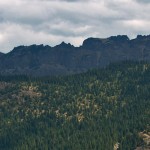
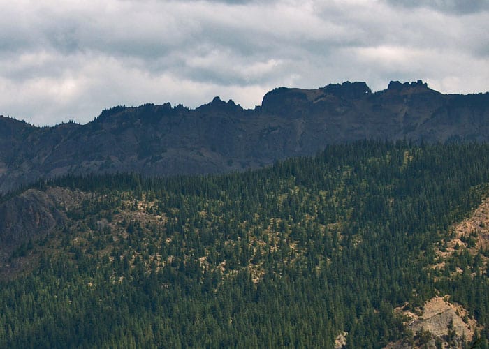
As with most of the trails in this area, you will travel through dense second growth forest for the first part of the hike. After a steady but moderate incline in the first 1.3 miles, you come across more open spaces and subalpine trees as you gain elevation. During the mid-summer, you will find the wildflowers in abundance from here to the ridge, especially the white rhododendron. During the early winter, before the snow gets too deep, these open areas also allow for nice views of the opposite side of the valley covered in a blanket of white snow. The trail flattens for a bit as it zig-zags through a ravine between hills, then continues at a slightly steeper incline and along a couple of switchbacks. At one point you see a rocky outcrop above you that seems out of place as it is different from other rocks both in color and texture. Another switchback or two and you are at the top of the ridge.
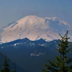
The view from here is spectacular as Mt. Rainier is only a couple of ridges away and dominates the horizon. If you are familiar with the Sunrise area, you will be able to pick out various locations on the ridge in front of the Mountain; Dege Peak, Sourdough Ridge, Fremont Lookout and Skyscraper Mountain. The White River is far below, cutting through the deep valley on its way to Puget Sound.
We like to wander around the ridge after eating lunch to photograph the wildflowers. To the north are the impressive cliffs of Corral Pass… always nice to see the destination of another trail from a distance. It makes you appreciate it in a different way. The trail continues along the ridge towards the resort offering more fantastic views, but this is where we turn around and head back the way we came. The scenery that was at your back on the way up, is a treat on the return trip.
The road to Sand Flats camp is 4.4 miles from Hwy 410 off of Crystal Mountain Boulevard, approximately 2 miles from the resort, and an easy one to miss if you aren’t looking for it. The driveway is on the right, just beyond the parking area for the Norse Peak trail, and travels a short distance to the end of the road. It looks like a horse camp with hitching rails and watering troughs scattered around the wide open space. (Lucky for you, there is a pit toilet here.) The trail begins at the bridge crossing Crystal Creek and then goes to the right on an access road to another large parking area at the base of a very vertical ski run. Here you pick up the actual trailhead.
– Mary Janosik
Waypoints
| Starting Point: 46.961944, -121.48388899999998 | |
| Notable Waypoints:
Parking at Sand Flats Horsecamp: N 46° 57′ 40, W 121° 28′ 52 |
|