| Area: Mowich Lake |
Hike Type: Overnight | Pass: Overnight Camping Permit & Natl Park Pass |
| Distance: 16.2 mi RT | Duration: 2 days | Difficulty Level: Strenuous |
| Elevation Start: 1,975 | Elevation End: 6,350 | Elevation Gain: 4,375 |
| Snow-Free: Mid-July – Oct |
-

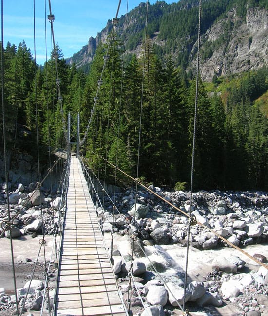
- carbon river bridge
-
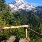
- eagle cliff view

-
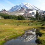
- spray park1

-
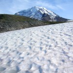
- seattle park snowfields

Alpine tundra, alpine meadows, a raging river, lush rainforest, and sparkling tarns; perhaps no other loop in Mount Rainier National Park packs so much in so few miles.
Experience a wide array of diverse landscapes and jaw-dropping views that will leave you both content and yearning for more. Starting from nearly mile-high Mowich Lake, this classic backpacking loop takes you through ancient cathedral forests, across silver strands of cascading waters, and to the snout of a massive snaking glacier. Then a stiff climb delivers you to a lofty frozen landscape before letting you roam through fields of dazzling wildflowers and pastoral parklands teeming with deer, bear and marmots. And you’ll get to feast on some stunning in-your-face views of the mountain reflected in pretty alpine pools flanked with dazzling wildflowers that sway in warm summer breezes. This loop captures the very essence of Mount Rainier National Park and what makes this place so special!
You can start this hike in either direction. While many backpackers prefer to do this loop counter-clockwise so they’ll face the mountain through Spray Park-I recommend clockwise, so you won’t have to finish with a grueling climb back to the trailhead. And besides, Spray Park is better for photographing later in day when the sun is not shining directly over Rainier’s glistening snowfields.
Start your loop by heading north on the Wonderland Trail skirting lovely Mowich Lake.
Named for the Chinook word for deer, chances are good of running into one of these forest denizens here at the lake. The trail rounds small coves and skirts lakeside ledges providing nice glimpses across placid waters to Fay and Castle Peaks. It then leaves the lake for a gentle climb through cool old growth forest to 5,150-foot Ipsut Pass.
Here, you can take a highly recommended scenic 1.7 mile side trail to Eunice Lake and the Tolmie Peak Lookout (el. 5,939 feet) where you can marvel at amazing views of the mountain. If you opt instead to continue on the loop, stay on the Wonderland Trail and begin dropping steeply through brushy avalanche slopes to the Carbon River. En route you’ll pass by a massive Alaska Yellow Cedar, one of the largest in the state!
Farther down trail you’ll pass by more massive trees as you traverse dank groves of magnificent old-growth hemlocks. At just over 5.0 miles from the trailhead you’ll reach a junction. Here at an elevation of 2,500 feet, the lowest point on the loop your trip turns right to follow alongside the roaring, milky glacier-fed Carbon River. But feel free to first head left for.3 mile to check out Ipsut Falls or set up camp for the night at the former car-accessed Ipsut Creek Campground. nNow heading east follow the wide channeled river through an interior-rainforest comprised of hemlock, cedar and Doug-fir. The air is heavy and moisture laden, and welcome on a hot summer day. At close to 7.0 miles veer right at a junction continuing along the roaring river. About one mile from the junction come to Carbon Camp, a nice place to spend the evening but not very quiet with the Carbon’s raucous noises bellowing through the valley.n
Beyond Carbon Camp, cross Cataract Creek and reach another junction. Your loop continues right on the Spray Park Trail, but you may want to make a quick side trip left first-to a suspension bridge across the Carbon River offering great viewing of the Carbon Glacier, the lowest (and one of the largest) glaciers in the Lower 48.
Your loop now leaves the valley to begin a long climb. At about 1.8 miles from Carbon Camp, come to the Cataract Valley Camp. Set up tent or keep moving on ascending higher. After passing cascading Marmot Creek forest yields to heather and huckleberry meadows. Watch for bears. You may get your feet wet crossing numerous tumbling creeks. Soon Mount Rainier reveals itself as you enter lovely Seattle Park. Be sure to gaze northward to a handful of the park’s lesser-known but intriguing peaks which include Tyee Peak, Old Desolate, and Crescent Mountain.
The way continues across heather meadows and skirts a couple of tarns before entering a landscape of tundra and rock. Route finding might be difficult in this section, so be sure to look for cairns and painted blazes on rock and ledge. You’ll also need to exercise caution through the permanent snowfields that are next encountered. Trekking poles are highly suggested-and an ice ax is a must in early season.
Your climbing ceases as you crest a 6,350-foot high shoulder. Cast off your pack for a breather and take in the sweeping views from the Olympic Mountains in the west all the way to Mount Baker to the north. Then start your descent into spectacular Spray Park. Here pass boulder gardens and fields flush in dazzling wildflowers. Admire several delightful tarns too that reflect Mount Rainier capturing all its glory.
Linger for awhile or carry on leaving Spray Park via a steep descent. After winding down a series of short switchbacks you’ll reach a junction. Do not skip the side trip left, a .1 mile jaunt to spectacular Spray Falls; a 300-foot cataract tumbling down an andesite cliff.
Then once back on the loop soon come to Eagle’s Roost Camp before making a short climb to Eagle Cliff where a breathtaking view back at the mountain can be caught. Then drop to skirt talus slopes before climbing once again. Intersect with the Wonderland Trail and take it right reaching your start at Mowich Lake in .3 mile. Consider a refreshing swim in Mowich Lake before heading home.
Overnight permits required and can be acquired by making a reservation or in person at the Carbon River Ranger Station (360) 829-9639; www.nps.gov/mora;
Special rules: No Fires-use camp stove. Dogs prohibited.
Special concerns: Permanent snowfields at Seattle Park may make travel difficult.
Trailhead directions: From Buckley follow SR 165 south for 10.3 miles bearing right on road to Mowich Lake. Continue another 16.8 miles (pavement ends at 1.6 miles) to road end at Mowich Lake.
Waypoints
| Starting Point: 46.933, -121.86410000000001 | |
| Notable Waypoints:
Trailhead at Mowich Lake: N 46° 55′ 58.62, W 121° 51′ 50.64 |
|