| Area: Eatonville |
Hike Type: Dog-friendly | Pass: No Pass Req |
| Distance: 5.75 mi RT | Duration: 2-3 hrs | Difficulty Level: Easy |
| Elevation Start: 485 | Elevation End: 1,185 | Elevation Gain: 700 |
| Snow-Free: Year-round |
-
- b MiddleFalls7

-
- c AnotherViewofMiddleFalls
-
- a MiddleFallsViewpoint2
-
- Coltsfoot

While Pack Forest is always a good four-season destination, in spring it is especially beautiful. Spring is our favorite time to hike here when hidden frog choirs sing to the heavens, birds dart and twitter, flowers bloom and waterfalls roar. You can almost taste spring on your tongue.
Our first visit to Pack Forest was in the early 1990s. Then – as now – we followed a system of numbered roads to Little Mashel Falls and other points of interest such as Hugo Peak, also featured on this website.
Pack Forest is named for Charles Lathrop Pack, a lumberman from the east coast who gifted the University of Washington’s College of Forest Resources with the means for the university to purchase forestland in the 1920s. Today the 4,300-acre forest provides an outdoor classroom for forest management students.
In the 1990s, the trail to Little Mashel Falls was not as well-signed as it is today; then you found the waterfall by hunch, luck or navigational skill. Little Mashel Falls was no mere trickle then; nor is it today. The series of waterfalls originate from the Little Mashel River, hence the “little.”
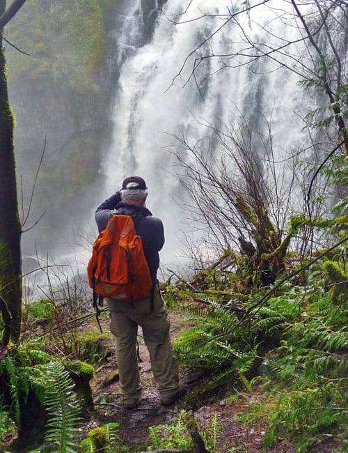
While the road junctions are better signed now, the waterfalls can be tricky to find for first-time visitors and the trails to overlooks can be hazardous in wet conditions. We recommend sturdy footwear for your hike to Little Mashel Falls at any time of the year. In late March the base of Little Mashel Falls was a crazed dervish of mist.
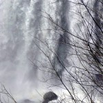
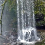
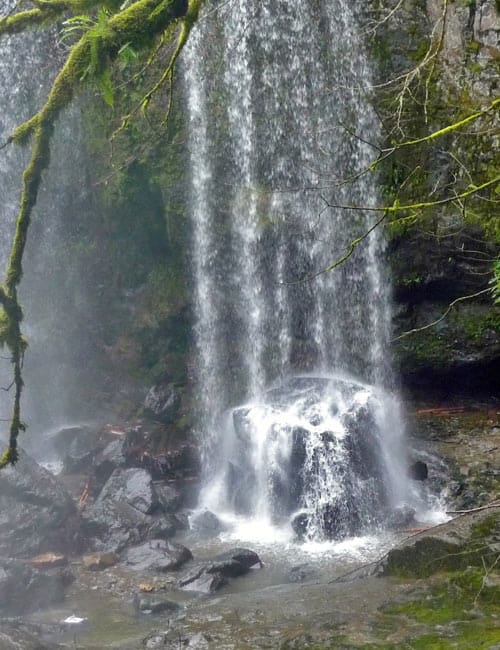
There has been some confusion as to the name of the waterfalls. Official word has it that Little Mashel Falls is correctly named; though it is still recognized by some as Bridal Veil Falls and trail signs refer to it as Middle Falls. There is also an upper waterfall (Tom Tom Falls) and a lower waterfall that is difficult to reach on an old, overgrown trail.
OK, you may well ask – how the heck DO you get to Little Mashel Falls and is getting there safe?
Getting to Little Mashel Falls is safe with good footwear along with a respect for staying within the boundary of Pack Forest (do exercise caution with children at the overlooks). Posted signs on paths to the waterfalls and overlooks alert you when you are leaving Pack Forest; in other words hike at your own risk.
The hike to Little Mashel Falls
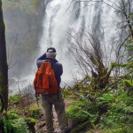
The hike begins from the upper trailhead parking lot (left) inside Pack Forest across from the administration buildings. There is also a lower parking lot (with portable toilet) between the gatehouse (entrance) to Pack Forest and the upper parking lot.
From the parking lot, walk a few steps up the main road to Road 1000 (Lathrop Drive) and directional signs. Turn left (a right turn takes you to Hugo Peak). Bypass all numbered roads until you reach a Y about 1-1/2 miles from the trailhead (elevation 1,185 feet) and a metal signpost designating the hiker-only Falls Trail. Here turn left onto Road 1070.
Shortly past the “Y” you’ll see a large boulder (left) with blue painted letters signed “Falls” with a directional arrow and another metal signpost. Note two trails (left), one is a rough path blocked off with branches and the other a wider track across a grassy area near a pond – this is the correct trail. Follow the grassy track as it skirts the pond followed by a brief descent to an obvious junction marked with three yellow diamonds. Turn right. Then turn left at the trail marker for Middle Falls and you’ll come to wooden steps that descend to an overlook of Little Mashel Falls (or Middle Falls).
The view of the waterfall is mesmerizing – the force of the spray so strong it wet our faces. Resist that urge to crawl under the rope barring access to a rough, slippery, path that drops to the base of the falls – it’s dangerous. The main trail continues a short way to another overlook; another good turnaround this time of year. In the summer when conditions are dry and water-levels low, experienced hikers can continue from that second overlook on a rough path to Lower Little Mashel Falls.
After viewing the falls we retraced our route back to the trailhead and continued hiking a short distance along Road 1070 to where it descends to an old railroad grade. Here we turned left and came to an old railroad trestle that spans the Little Mashel River. The river makes a big bend as it goes under the trestle, then pours over a lip to form Upper Little Mashel Falls (also known as Tom Tom Falls).
After warming up a few moments in the sun we retraced our route back to the parking area and met a few hikers coming in. One couple asked if we knew how to get to Little Mashel Falls and we were happy to tell them.
To get there:
From Seattle drive south on Interstate 5 to Tacoma, get off at Exit 127 for Highway 512 and in about two miles exit onto SR 7 (toward Spanaway). Continue on SR 7 to the signed entrance of the University of Washington Pack Forest (left), 781 feet elevation. Enter Pack Forest and continue to the lower parking lot or upper parking lot (903 feet elevation).
Additional Information:
Visitors can usually pick up a map at the administration buildings or at trailheads, but maps are not always available. There were none available on our visit – we advise printing out a map of the trail system before you go. In addition to printing out a map from the website, you can also get more specific driving directions based on where you are located and links to Pack Forests’ history: www.packforest.org or call 206-685-4485.
– Karen Sykes, Visit Rainier Hiking Expert
Waypoints
| Starting Point: 46.8431319122786, -122.31794531122057 | |
| Notable Waypoints:
Entrance: N 46° 50′ 39, W 122° 19′ 02 |
|