| Area: White River |
Hike Type: Wildflowers | Pass: Natl. Park Pass |
| Distance: 12 mi RT | Duration: 6.5-8 hrs | Difficulty Level: Moderate |
| Elevation Start: 3,808 | Elevation End: 6,755 | Elevation Gain: 3,177 |
| Snow-Free: July – Oct |
-

- no place to fall

-

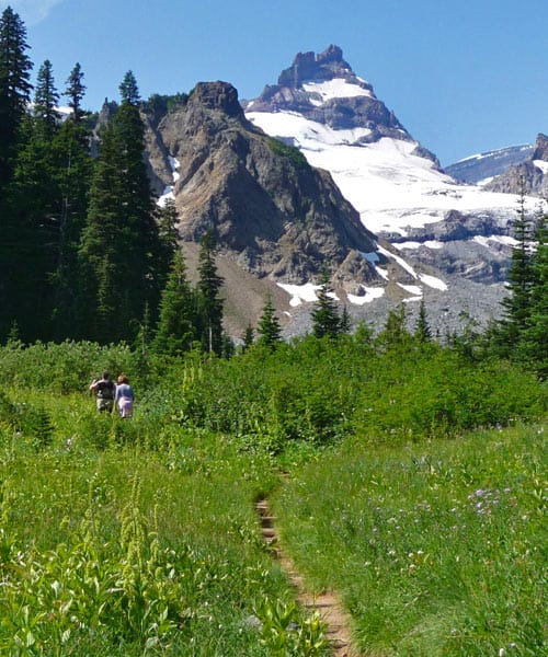
- Hikers enroute to Summerland
-

- marmot dance

-

- summerland

-

- a hikers below the gap
-

- lunch with a view
-

- tarn below Panhandle Gap
If heaven were a geographical destination it might resemble Summerland. Where else can one find such lavish meadows, magical tarns, psychedelic-colored moss interspersed with purple masses of penstemon hugging the banks of glacial streams? Include the earth-toned hues of the moraine below Panhandle Gap; in August the gap still a stronghold guarded by a cornice. And there’s more to see: the Winthrop Glacier and Little Tahoma, a conglomeration of volcanic rock barely held together with snow and heavily crevassed. Climbers will tell you that rock on Little Tahoma is rotten and brittle, the route enigmatic.
The hike starts off quietly on the 93-mile Wonderland Trail as a climb through forest with overlooks of Fryingpan Creek crashing down a steep gorge. On a previous visit in June we watched a mother bear and two cubs trundling up the trail ahead of us; one of the cubs was black, the other brown. Here you may notice evergreens that have been stripped of their bark by bears to sharpen their claws or to mark territory. The forest provides a good hangout for them with berries ripening and a creek nearby. In August they may have moved on; this popular trail may be a little too busy for them.
At about three miles, Fryingpan Creek is crossed on a footbridge (N 46° 52′ 09″, W 121° 39′ 13″; 5,250 feet) – it’s not the sturdiest-looking bridge in the park, but sufficient. This is where Fryingpan Creek flows over a cliff before plunging into the gorge. This setting is a good turnaround for hikers seeking an easy hike with rewarding views at the end. Find picnic spots with boulders serving as chairs beside Fryingpan Creek with views of Mount Rainier.
After crossing the creek, the Wonderland Trail climbs in switchbacks en route to Summerland; here the grade of the trail is steeper. We’d heard that wildflowers had waned but in August we saw plenty of them: valerian, bistort, lupine, magenta Indian paintbrush, Jacobs ladder, arnica, even a few avalanche lilies.
As the trail breaks out into the heralded meadows of Summerland you almost expect to hear a chorus singing; yes, it’s that inspiring. There are also expanding views of Mount Rainier, the Winthrop Glacier and Little Tahoma. A junction directs hikers to continue on the Wonderland Trail or stop at Summerland Camp with nearby campsites and a group camp (5,939 feet).
Many hikers stop there – Summerland is a wonderful day hike. Backpackers can camp at the rock shelter, a group shelter (reservations are required for all campsites). We stopped to see the rock shelter and found it surprisingly clean. There are also campsites scattered nearby, some with a view.
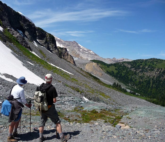
Past Summerland Camp, the Wonderland Trail continues, making a beeline across a large meadow as it heads toward Panhandle Gap. The scenery between Summerland Camp and the moraine above is splendid though it may be difficult to distinguish where meadows end and the moraine begins. As the trail climbs, meadows gradually give way to the rubble of a moraine. Interspersed with rocks are psychedelic-green mosses, wildflowers and meadows so tender they’d flinch if you stepped on them.
Beyond Summerland Camp, the trail is lined with rocks and the message is clear; stay off the meadows! One hiker we met said he’d wandered off trail for a photograph but a park ranger stopped him and handed him a button to wear that read “Don’t be a meadow stomper”; the hiker was chagrined. Signs also help remind visitors that these high alpine meadows are fragile.
As we headed toward Panhandle Gap we were a little surprised to see how much snow still lingered in late August. Though we were equipped with ice axes, our guest was using trekking poles and was a little uncomfortable hiking on snow.
We crossed a stream on a footlog, entered even more open terrain, and looked upon a collection of boulders, talus, thatches of moss, ground-hugging wildflowers and stunted evergreens much older than they appear. Evergreens at elevations struggle to adapt to harsh conditions by extending their lower boughs out in a cushion-like effect, a process called krummholz, rather than growing tall and straight (krummholz is German for “crooked wood”). With their wide base and growing low to the ground these “dwarfed” trees (not all) can survive wind and months of deep snow.
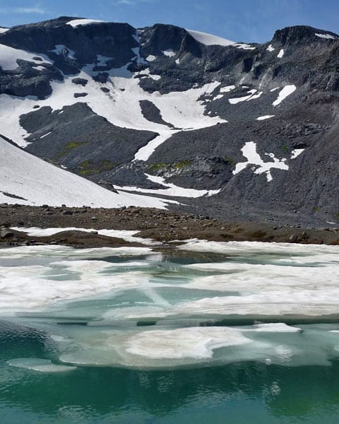
As you follow the rock-lined trail you’ll notice two partially thawed tarns (N 46° 51′ 28″, W 121° 39′ 06″; 6,361 feet); the lower tarn was green in color, the upper tarn turquoise. Photographers may want to spend time here taking photos of reflections in the tarn and the abstract shapes of melting ice floating on the surface.
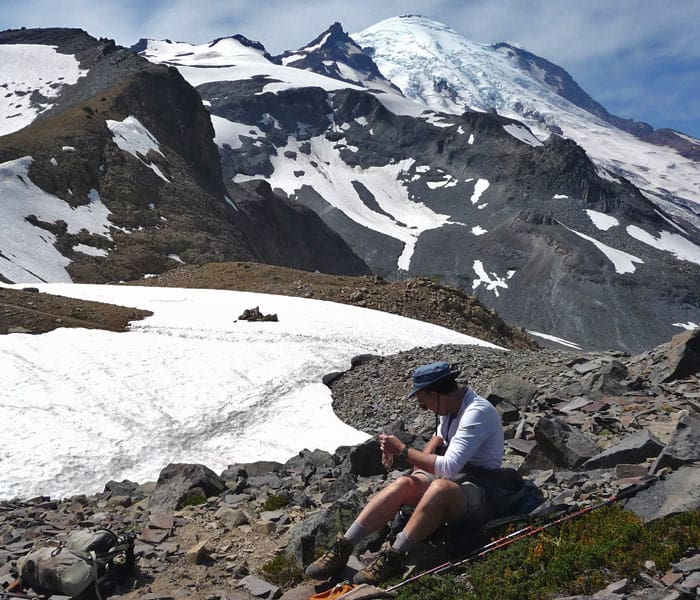
As we climbed, we began to encounter more snow and took a closer look at Panhandle Gap; we were within reach energy-wise but the last stretch looked challenging with a narrow path beaten into the snow above a run-out of rocks – not a good place to slip. We pressed on a little further, agreeing to hike only as far as everyone was comfortable.
Earlier I’d read an account of this hike in which a hiker referred to that last stretch of snow below the Gap as the traverse of “doom.” When we got to the steep snow I started out ahead and found the snow good for kicking steps but as we watched hikers with trekking poles descending from the gap ever-so-gingerly (doesn’t anyone use an ice axe anymore?); it became obvious that some hikers might feel uneasy on that last 20-plus feet to Panhandle Gap, including our guest. Such terrain is only recommended for experienced hikers with appropriate skills and taking an ice axe would not be overkill.
Rather than continue we backtracked to a rocky saddle (6,734 feet) below Panhandle Gap (6,755 feet) for lunch and made that our turnaround. The saddle was so pleasant that we lingered to enjoy the views. We also noticed a path that hinted of a way to get around behind Panhandle Gap that would eliminate that exposed traverse across the snow, but our time was limited. The days are already growing shorter so budget time and energy accordingly if you hike in September or later. We wish we’d started earlier – it was one of those days we felt we could hike forever.
Part of the fun of hiking the Wonderland Trail is the interesting people you meet on the way. We met Beth Rossow who was backpacking to Mowich Lake, currently working on measuring and photographing the Wonderland Trail for another edition of Bette Filley’s “Discovering the Wonders of the Wonderland Trail”. Beth worked with Bette Filley on the 1993 edition. By the way Bette was recently at Wapiti Woolies signing books – wish we’d known.
On the bridge at Fryingpan Creek we met an elderly gentleman with his son also bound for Panhandle Gap and we chatted a bit. It turns out the son of the middle-aged man (and the grandson of the older gentleman) was climbing to Camp Muir the same day we were hiking to Panhandle Gap. He’d planned to summit Rainier that day, run around the mountain on the Wonderland Trail the following day – oh yes, he had ridden his bike to Mount Rainier from Ballard the previous day.
To get there: From the White River entrance of Mount Rainier National Park (via SR 410) drive about three miles to the trailhead and parking.
For additional information on fees, rules and regulations, current conditions, weather, reserving campsites call Mount Rainier National Park (360-569-2211) or visit their website at www.nps.gov/mora. The recommended map for Mount Rainier National Park is Green Trails (Mount Rainier Wonderland Map 269S).
– Karen Sykes, Visit Rainier Hiking Expert
Waypoints
| Starting Point: 46.88796, -121.61046 | |
| Notable Waypoints:
Trailhead: N 46° 53′ 17, W 121° 36′ 38 |
|