| Area: Sunrise |
Hike Type: Mountain Views | Pass: Natl. Park Pass |
| Distance: 10.44 mi RT | Duration: 5-7 hrs | Difficulty Level: Moderate |
| Elevation Start: 3,600 | Elevation End: 6,350 | Elevation Gain: 2,750 |
| Snow-Free: July – Sept |
-
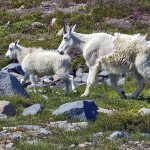
- c shagging up for cold weather

-
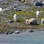
- b herd of mountain goats

-
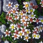
- d tolmies Saxifrage

-
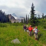
- a group returns from Summerland
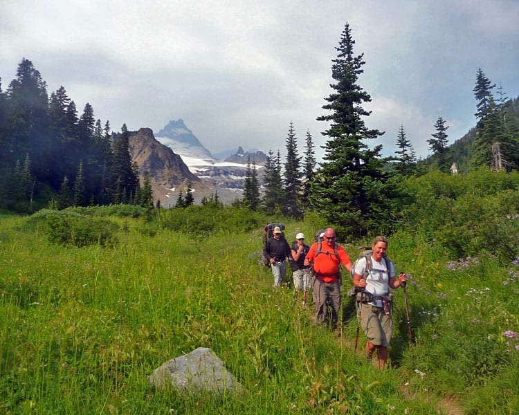
This is one of the most popular hikes in Mount Rainier National Park and you’ll see why once you’re on the trail. What makes this hike so popular are the views of the Fryingpan Glacier, Little Tahoma, Goat Island Mountain, Mount Rainier, and Panhandle Gap…for starters. Add to that a herd of 30 (we counted) mountain goats and lots of wildflowers blooming at Summerland – these are just a few reasons you’ll want to head that way before cold weather sets in once again.
Speaking of cold weather it’s a good idea to add an extra layer of clothing to your pack – mornings can be chilly this time of year though it’s apt to feel like summer by the afternoon. Figuring out what to wear (and pack) can be tricky in late-August, early-September. When in doubt, pack a little extra.
You might not want to see a bear but bears are not uncommon inside the park, and whether or not you’ll see mountain goats is also a bit of a gamble. Unless Summerland is socked in with clouds you can count on views and even on a gloomy day, the brilliant late-summer flower displays and the myriad shades of blue and green of tarns created by melting snow. If it’s a sunny weekend, you can also count on crowds, so get an early start.
The trail gets off to a gentle start in the forest before it climbs to the first in a series of switchbacks with views of Fryingpan Creek (about two miles). These switchbacks are usually in the sun and are handy if you need a break before continuing to Summerland. In the forest, you’ll cross a couple of streams and as the trail approaches Fryingpan Creek, you’ll see wildflowers – fireweed, asters, mountain daisies, and pearly everlasting.
Fryingpan Creek is the last place to refill water bottles before Summerland; the creek is also a pretty setting with views of Little Tahoma, Goat Island Mountain and depending on the play of clouds, you might see part of Mount Rainier as well. Crossing the creek won’t be a problem for adults thanks to a foot-bridge (N 46° 52′ 31″, W 121° 37′ 28″); however the railing on the foot-bridge is set a little far out from the bridge and it’s on the downhill side above a waterfall – children might need a helping hand as their arms may be too short to utilize the railing.
After crossing the creek the trail meanders through an aster-studded meadow before beginning a short, steep climb to Summerland. The switchbacks are short and sweet as here the trail is sweetly scented with flowers (most of the perfume is generated by valerian). There are also ever-expanding views of Little Tahoma and enough wildflower displays to stop you in your tracks. Between the trees, the hillsides are blanketed with wildflowers. Between Fryingpan Creek and Summerland we saw several varieties of wildflowers including lousewort, lupine, asters, mountain daisies, magenta paintbrush, bistort, and valerian. We also saw signs of fall such as the swirled leaves of hellebore threaded with gold.
When you get to Summerland you’ll come to a signed junction at the edge of a big meadow – the main trail (straight) continues through the meadow and on toward Panhandle Gap. The trail (left) goes to the shelter and designated campsites (reservations required). There’s also an outdoor toilet in a secluded setting uphill from the shelter (it is signed). Hikers are not allowed to camp inside the shelter but it’s a cozy spot in bad weather for backpackers to prepare their meal or day-hikers to enjoy a lunch out of the rain.
Summerland is beautiful enough that it may be far enough for some hikers though strong hikers can continue to Panhandle Gap, even beyond. If you do hike to Panhandle Gap there is still enough snow up there that taking an ice axe or trekking poles is advised. Mornings are getting cold enough that the remaining snow can be hard and unforgiving – it’s not a place to fall.
If Summerland feels too crowded but you don’t have the energy to climb to Panhandle Gap, there are other places you can settle between Summerland and Panhandle Gap. Continue on the main trail and you’ll find many spots conducive for stopping – flat boulders abound all along Fryingpan Creek. Views? Just about anywhere you look. Another spot to consider for a lunch (or turnaround) is where Fryingpan Creek is crossed again on a wide, flat log.
From the creek crossing, you can also continue hiking until you come to two tarns on the right-hand side of the trail (below Panhandle Gap). Here there are closer views of Panhandle Gap (as of August 27 there was still quite a bit of snow below Panhandle Gap) as well as close-up views of wildflowers and the artistic shapes of melting ice in the tarns. Here you will also find several flat-boulders that are comfortable enough to sit upon; some even large enough you could even stretch out for a nap.
Shortly after we settled down for lunch at the upper tarn we were initially puzzled (then amazed) to spot a herd of mountain goats descending a snow-field toward the lower tarn. Since mountain goats and snow are both white, we couldn’t figure out what we were looking at until they got off the snow and onto the moraine. Try watching white stick-figures in the distance moving across the snow (white on white) and you’ll see what we mean. Getting to see the goats was a bonus – we’ve never seen so many in one place.
Should you ever meet a mountain goat (or any large animal) that won’t move off the trail as you approach (or approaches you) back off slowly. You can usually tell if a goat is getting ready to confront you if it starts scuffing its hooves and lowering its head. Goats are a little edgier when with their kids. There have been injuries, even a fatality caused by an aggressive goat. As much as we love animals we treat them with respect and give them plenty of room.
We lingered over lunch for the pure joy of watching the goats drink and graze. We also noticed that there were many kids in the herd. The goats seemed to be on the same time-clock and began drifting away from the tarn back up onto the snow. We’ve learned since that after their breeding season is over, males and females separate. The billies (males) break up into small groups of 2-3 but females (nannies) and kids form loose-knit groups of up to 50. These are sometimes referred to as “nursery” groups.
Though wildflowers are fading at lower elevations they are still going strong from Summerland on up toward Panhandle Gap. Beside Fryingpan Creek we saw clumps of yellow and pink monkeyflowers and fat cushions of lime-green moss, edged with alpine sedges. We also spotted partridge-foot and leather-leaf saxifrage (a small red plant with heart-shaped flowers) mixed in with the monkeyflower and moss. Where the terrain transitions from rock/flower gardens to a more austere setting of rocks and snow we spotted several small alpine flowers including Tolmie’s saxifrage and Alpine Buckwheat.
As we hiked back to Summerland we stopped to enjoy the somewhat disquieting views of the Emmons Glacier (as we’d hiked up to Summerland the glacier was behind us). The glacier looked ominous – the crevasses so close together that it was hard to tell where one ended and another began.
On our way down we met a hiker who’d reported a bear had gotten into her pack when she’d left the trail briefly for a “party separation.” Be extra vigilant when it comes to bears – if you venture off trail for any reason do not set your pack down unless someone will watch over it or take it with you.
We didn’t see the bear but just after crossing Fryingpan Creek we spotted something equally shocking – gentians blooming beside the trail! We refer to these as the “goodbye flower” because they signify the end of summer. While we admire these blue flowers that glow like Tiffany lamps when the light’s right, we don’t look forward to the end of summer’s brilliance.
To get there: From the White River entrance of Mount Rainier National Park (via State Route 410) continue about three miles to the trailhead on the Sunrise Road – the trailhead is on the right-hand side just past the Fryingpan Creek road bridge. No facilities. A pass or a fee is required to enter the park – for details refer call 360-569-2211 (Park Headquarters) or 360-569-6575 (Park Information).
Map: Green Trails No. 269S, Mount Rainier Wonderland
Note: The hike to Summerland is 7.25 miles round trip with an elevation gain of 2,100 feet. The hike to the tarns above Summerland is 10.44 miles round trip with a gain of 2,750 ft.
– Karen Sykes, Visit Rainier Hiking Expert
Waypoints
| Starting Point: 46.88812, -121.6103 | |
| Notable Waypoints:
Trailhead: N 46° 53′ 17, W 121° 36′ 37 |
|