| Area: Westside Road |
Hike Type: Mountain views | Pass: Natl. Park Pass |
| Distance: 12.4 mi RT | Duration: 7 hrs | Difficulty Level: Strenuous |
| Snow-Free: July – October | High Point: 5,465 ft | Elevation Gain: 2,600 ft |
-

- IMG 6621

-
- IMG 6521

-
- IMG 6601
-
- IMG 6536
-
- IMG 6627

-
- IMG 6623
-
- IMG 6516
-
- IMG 6512

Features: historic fire lookout, historic patrol cabin, subalpine lake, exceptional old-growth, alpine views, backcountry camping
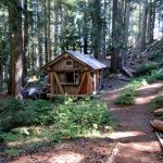
At 5,485-feet, Gobblers Knob is the lowest of Rainier’s four remaining fire lookouts. It used to be the shortest to reach too. Now, you must walk (or bike) 3.8 miles of the closed Westside Road to get to the old trailhead. While this hike is long—it is not difficult. The road is easy walking and the trail is wide and well-graded. The old-growth forest along the way is magnificent and Lake George makes for a nice lunch spot; or if you’re inclined to spend the evening—a great camping spot. And the views? Breathtaking to the point that you just may need a little resuscitation!
Hit the Trail
This hike begins with a long approach on the Westside Road before reaching the Gobblers Knob Trail. The Westside Road was built from 1926 to 1934. Park officials originally envisioned building the road all the way to the Carbon River. But concerns over costs and the road’s impact on fragile environments led to a halt on construction at the North Puyallup River. In 1989 due to recurring mud and debris flows over the road from Tahoma Creek, the park permanently closed the road to visitors at Dry Creek.
The road is still maintained however, to allow emergency and park personnel access to the remote west side of the park. And while you can’t drive on the road—you can ride your bicycle on it. So consider biking to the original Gobbler Knob Trailhead at Round Pass. You’ll really appreciate the return with a mostly downhill route. Otherwise, start trudging up the road.
Pass the barrier and cross Dry Creek and reach a former parking area near a gate. Park officials concerned over constant rock fall at this spot, recently closed off this area to parking. Now walk along the base of Mount Wow, and stand in awe of this peak’s sheer and intimidating cliff faces. You may indeed exclaim, “Wow!” But the mountain wasn’t named for a reaction, but after mountain goats. Wow is a corruption of a Yakima Indian word for mountain goats. Look up at those cliffs for moving patches of white, as goats frequent them. Then mutter wow upon seeing them.
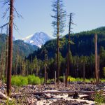
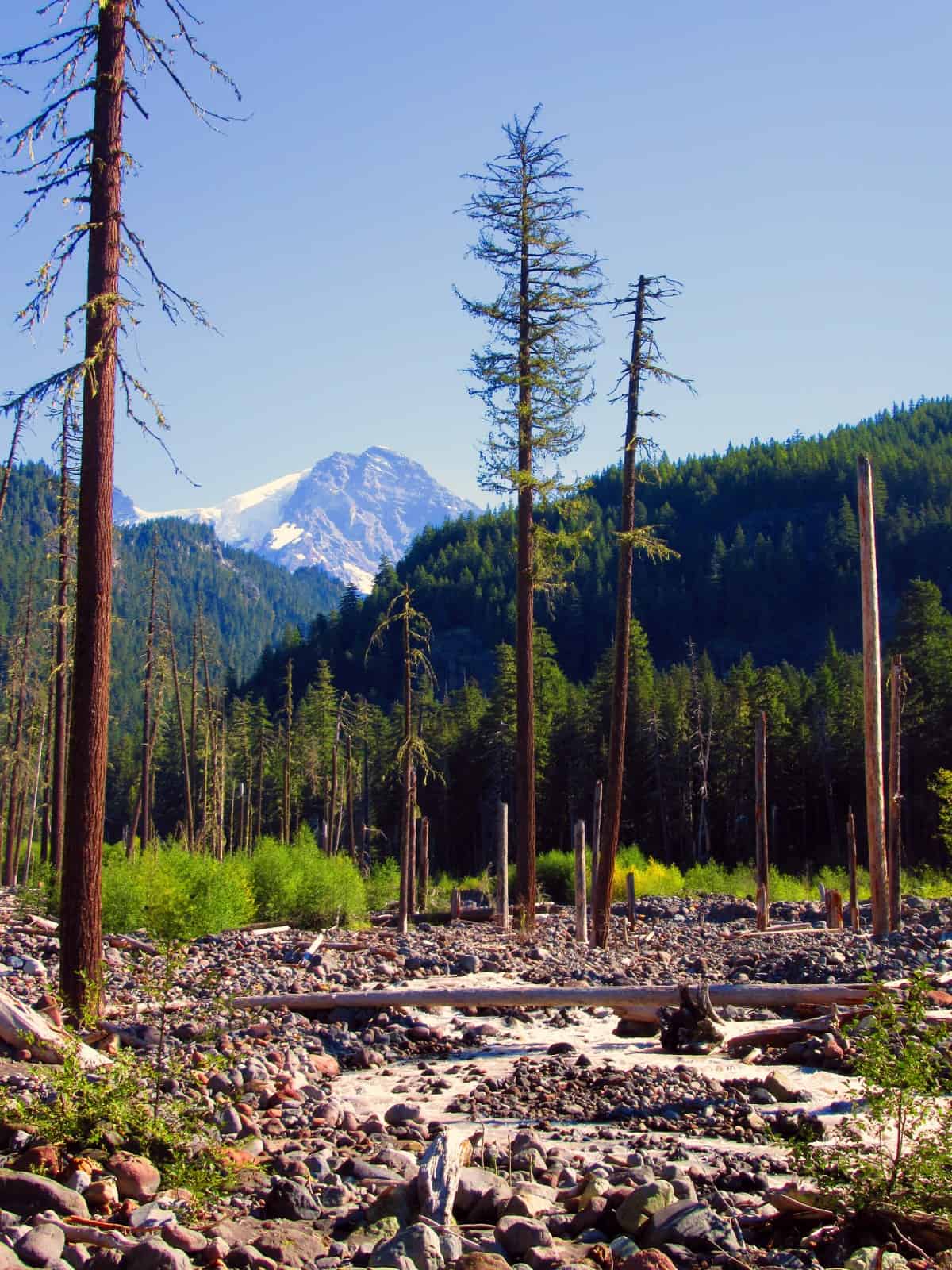
The road crosses Fish Creek on a bridge and then brushes alongside Tahoma Creek on a much rougher path. The creek has claimed chunks of this road year after year and park officials continuously patch it up. Enjoy excellent views of Mount Rainier rising above snags in the glacial till and rocky outwash of the creek. Enjoy a good view too, of Mount Ararat, looking far more impressive from this angle than from Indian Henrys Hunting Ground.
The road then passes the primitive Tahoma Creek Trail and makes a couple of wide switchbacks to the Tahoma Vista. The Vista has long since grown in. Work crews have recently restored some of the historic stonework here—and that may be of some interest to you. The road then makes a long traverse—followed by a couple of more switchbacks—and another long traverse—finally reaching forested 3,900-foot Round Pass at 3.8 miles.
Locate the trailhead on the left side of the road near an old parking lot. Now on real trail, enter a luxuriant old-growth forest. The trail is wide and well-graded and a pleasure to hike. Before the road was closed, it was one of the most popular trails in the park. Now, it’s not uncommon—especially in the autumn to have the trail all to yourself.
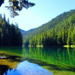
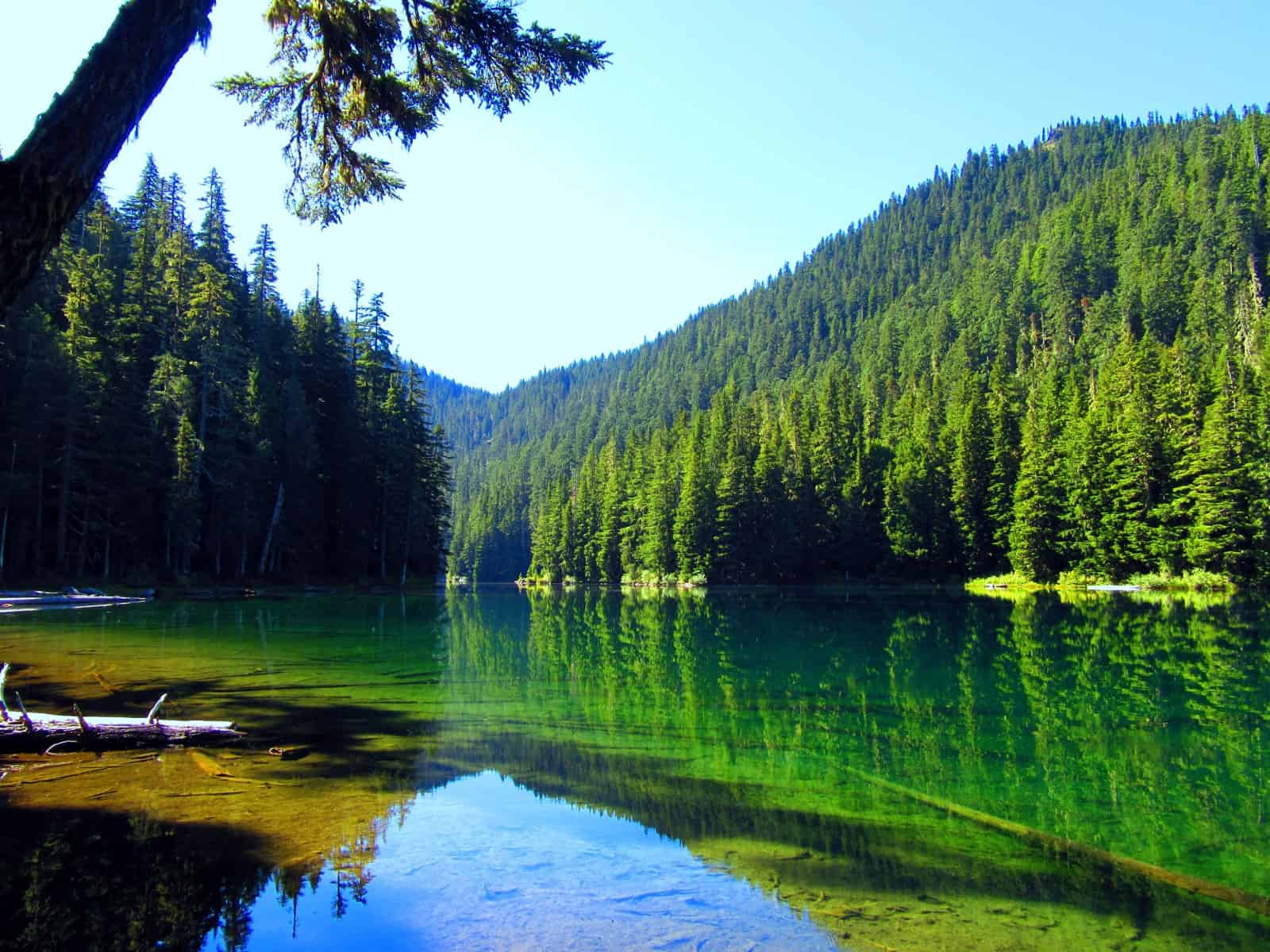
The trails works its way up a bench. Look east through the big trees to a constant white backdrop. At 4.6 miles reach Lake George. Definitely, take time to explore this long lake tucked beneath the northern slopes of Mount Wow. Surrounded by emerald giants and emanating a green hue, it’s a verdant body of water. Way paths lead along both its eastern and western shores. An old ranger patrol cabin is tucked in the woods near the lake’s northeastern corner. Here too find attractive campsites (permit required to camp) and a big shelter.
The trail continues past the lake passing through more magnificent primeval forest before reaching a pocket meadow. Here look up and see the fire lookout teetering on rocky Gobblers Knob. The trail then decides to gain some elevation commencing in some short switchbacks. Soon reach a small pond—where the lookout can once again be seen.
Now climb again and come to a junction. Here the Goat Lake Trail leaves left to steeply descend to Goat Lake in the Glacier View Wilderness. This trail (known as the Puyallup Trail in the adjacent national forest) is accessed via rough-and-tumble FR and makes for a much shorter hike to Gobblers Knob.
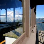
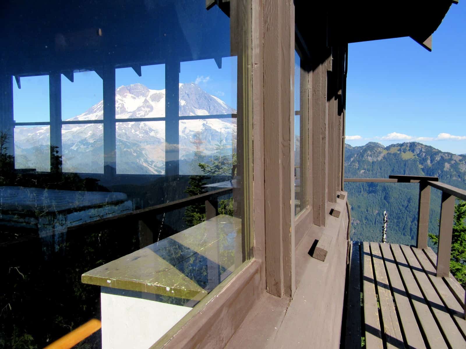
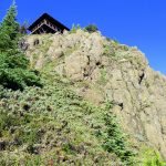
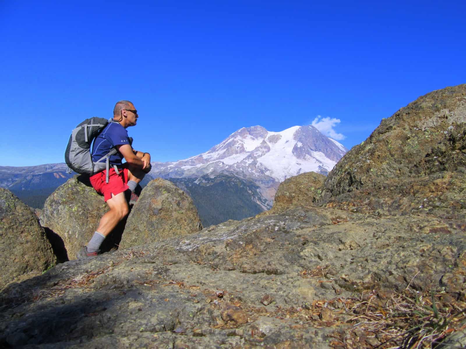
At this junction turn right and follow a couple of short switchbacks to gain the last few hundred feet of elevation. The trail works its way under the rocky knob and crests the long rugged ridge emanating north from Mount Wow. It then swings around the knob to ascend it from the north. Stay on the trail—as it is a heck of a drop. Approaching the summit, clutch your chest. The view of Rainier—practically in your face—will knock your breath out! Now ascend the steps of the 1933-built fire lookout perched on the rocky pinnacle.
Walk the catwalk and be blown away by some of the best views in the park. Look south to the Goat Rocks, Pyramid Peak, Mount Wow, High Rock and Mount St. Helens. Look west to Goat Lake straight below and the sawtooth Glacier View Wilderness Peaks. Look farther west to the Black Hills and Olympic Mountains. Look north down the deep Puyallup River Valley and out to the Colonnade and Tolmie Peak. And look east straight at the mouintain—especially the Tahoma Glacier. It’s an impressive site of snaking snow and ice terminating in cascades whose roars can be heard from the lookout!
Stay for a while and soak up the incredible views. And perhaps start wondering, why gobbler? Back in the 1930s when this lookout was being built, one of the CCC crewmembers hailed from Tennessee—a state with no shortage of wild turkeys. This young worker thought this rocky knob looked a lot like the ones in the Smoky Mountains where he hunted for turkeys. Hence the name. But one thing is for sure—this hike is no turkey!
Notes: Dogs prohibited. Backcountry camping permits required (attain at Longmire Wilderness Information Center) to spend the night at Lake George. Practice Leave No Trace Principles. Contact: Mount Rainier National Park; https://www.nps.gov/mora/index.htm; (360) 569-2211
Maps: Green Trails Mount Rainier National Park 269S
Trailhead directions: From Elbe at the junction of SR 7 and SR 706, head east on SR 706 passing through Ashford and reaching Mount Rainier National Park at 14 miles. Continue west on park road for 1 mile and turn left on graveled Westside Road. Then continue 3.2 miles to barrier just before Dry Creek. This is the start for this hike.
Trailhead facilities: None; privy available at nearby Kautz Creek Picnic Area.
– Craig Romano, is an author of more than a dozen hiking guidebooks including the newly released 100 Classic Hikes Washington (Mountaineers Books) which includes several hikes in and around Mount Rainier National Park.
Waypoints
| Starting Point: N46 46.719 W121 53.000 | |
|
Notable Waypoints: Trail junction at Round Pass: N46 48.062 W121 53.886 Lake George: N46 47.563 W121 54.197 Gobblers Knob: N46 47.660 W121 54.858 |
|
Q: Can I book the lookout tower at Gobbler’s Knob for an overnight stay?
A: No, the lookout tower is not available for overnight reservations. Overnight camping in or at the lookout tower is not permitted at this time.