| Area: Mowich Lake |
Hike Type: Mountain views | Pass: Natl. Park Pass |
| Distance: 7.8 mi RT | Duration: 4 hrs | Difficulty Level: Strenuous |
| Elevation Start: 3,470 | Elevation End: 3,470 | Elevation Gain: 200 in / 950 out |
| Snow-Free: April – Oct | Snow-Free: April – Oct |
-

- shelter graffiti

-

- shelter2

-

- mowich river flood plain

-

- rainier1
-

- windstorm debris

The Paul Peak Trail is unique in so many delightful ways. Unlike most trails that go up from the trailhead, this one drops down over 1100 ft. to the Mowich River Valley. And although you won’t find breathtaking waterfalls or pristine alpine lakes, you will experience carpets of lush ferns and woodland flowers, stellar mountain views, and the devastation of a recent windstorm reminding us of nature’s awesome power.
What type of scenery is along Paul Peak?
In only four miles, the trail takes you through several distinct landscapes. The first stretch drops steeply from the parking lot to Meadow Creek in 0.6 miles. The surrounding forest floor is covered in lush ferns and woodland flowers and the trees are simply majestic. The morning light is heavenly as it filters through the woods. The next section takes you on a gentle, but constant uphill trek around the side of Paul Peak. As you gain elevation, the forest floor changes to earthy browns with some Oregon Grape and salal. The trees aren’t as big, but they are numerous. And then the fun begins…
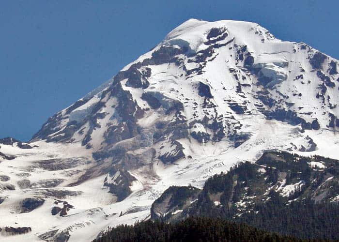
Originally, there were no places on this trail to get an unobstructed view of Mt. Rainier… until sometime in the early spring of 2004. While this area of the park was still closed for the winter season, there was a powerful windstorm that toppled dozens of very tall trees on the south side of Paul Peak. This cleared a large opening on the steep hillside that allowed a unique view of Rainier. The trail on this vertical slope has 24 switchbacks dropping down the mountain in a one-mile stretch. The trees fell uphill, each crossing the trail numerous times. It became a massive task for trail crews to clear the path. Many trees had to be cut several times to clear the switchbacks. The debris is incredible as it remains there today. But with the devastation, came new and breathtaking views of Mt. Rainier’s northeast flank. The “Elk Head” is in clear view, just below the summit.
As you continue dropping down, the vegetation gets lush again with the sounds of the river telling you that you must be getting closer. Before reaching the bottom of the Mowich Valley, you arrive at the junction with the Wonderland Trail… left will take you back up the mountain to Mowich Lake in 3.2 miles, right takes you to the Mowich River (North and South Forks) and the Mowich River Camp and Shelter. The camp is usually our destination for a day hike. Here we enjoy our lunch and take some time to explore the glacier-fed rivers and the cool, rainforest-like landscape. The flood plain of both forks reminds you of the unrivaled power of Mother Nature who has re-arranged the scenery each time you visit.
If you continue along the Wonderland Trail, across the South Fork of the Mowich River, you will reach Golden Lakes Camp, a pretty long uphill trek for a day hike from the Paul Peak Trailhead. Many people use that destination for an overnight trip and we hear it’s a beautiful place to spend a night. You could possibly meet up with hearty hikers on their way around The Mountain.
How difficult is the Paul Peak hike?
Some trail books list this hike as moderate and parts of it are. But much of it is fairly steep so depending on your physical ability, you can stop at the delightful Meadow Creek for lunch, or go as far as the 3rd or 4th switchback for incredible views of the Mountain. But be advised if you continue down the steep side of Paul Peak, it’s a LONG WAY back to the parking lot.
You will find this trail in the northeast corner of Mt. Rainier National Park. Past Wilkeson, on Hwy 165, the road crosses the one-lane Fairfax Bridge and then forks… take a right onto the Mowich Lake Road. Travel 11+ miles to the park boundary and the Paul Peak Trailhead. Here you can purchase your park entrance pass, before heading out on your adventure. (Mowich Lake is only 6 miles farther and as long as you are here, you might as well visit this gorgeous place, too.)
The Paul Peak Trail a trail not soon forgotten in a beautiful, not often-visited corner of the park. In the summer, don’t forget your bug spray. In the fall, you are allowed two liters of mushrooms per day and they are plentiful along this trail (both edible and inedible).
– Mary Janosik, VisitRainier Hiking Expert
Waypoints
| Starting Point: 46.93477674028925, -121.90724979629516 | |
| Notable Waypoints:
Trailhead: N 46° 56.088′, W 121° 54.439′ |
|