| Area: Westside Road | Hike Type: Overnight | Pass: Overnight Camping Permit |
| Distance: 21.4 mi RT | Duration: 2+ days | Difficulty Level: Strenuous |
| Elevation Start: 1,350 | Elevation End: 5,950 | Elevation Gain: 4,600 |
| Snow-Free: Mid-July – Oct |
-
- White Pass Red Pass 580

-

- White Pass Red Pass 696
-
- White Pass Red Pass 692

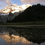
There are many legendary spots along Mount Rainier National Park’s 93 mile-long Wonderland Trail. Their names alone-Indian Bar, Summerland, Indian Henry’s Hunting Ground, Spray Park, Moraine Park, Emerald Ridge-conjure up awe and amazement. Count Klapatche Park among them. And if mention of this name doesn’t instill in you a sense of wonderment, it forever will once you set up camp here at the edge of a small lake that reflects the full splendor of Rainier.
Named for one of the greatest Puyallup chiefs of all time, Klapatche Park is one of the greatest spots to spend the night along the Wonderland Trail. The late legendary Northwest guidebook author Harvey Manning called the backcountry campsites at Klapatche Park the most beautiful on the entire Wonderland Trail. I concur-and unlike other breathtaking camping spots along the Wonderland Trail, this one is far from roads leaving it out of reach to the park’s legions of day hikers. At Klapatche Park you’re guaranteed a wilderness experience-a chance to share this breathtaking park with few fellow hikers and plenty of Rainier’s wild residents. From your snug campsite you can not only watch the evening and morning sunlight dance off of the mountain’s glaciers perfectly mirrored in Aurora Lake below-but also stand witness to bears, mountain goats, and deer frolicking in the surrounding high parkland meadows.
The trip is arduous, but strong backpackers can make it to Klapatche Park in a day. Otherwise, plan on spending a night along the South Fork of the Puyallup River en route. Be sure to secure your overnight permits before setting out. Start your trip by walking up the closed to traffic gravel Westside Road. Originally planned to run all the way to Mowich Lake, construction crews reached Klapatche Point in the 1930s. But plans to continue the road to Mowich were soon abandoned and after enduring numerous washouts along Tahoma Creek, the road was permanently closed in the late 1980s. It now makes for a quiet walk-or you can mountain bike it and stash your bike at several former trailheads and shorten your hike.
nBegin your trip up the road with cliffy Mount Wow hovering above you on the left and thundering Tahoma Creek roiling by you on your right. Slowly ascend passing the Tahoma Creek Trail after about 1.8 miles. Just beyond come to the old Tahoma Vista Picnic Area. The views and the grounds are quickly be reclaimed by feisty vegetation. At 3.8 miles, come to 3,900-foot Round Pass complete with bike racks for securing your bike. Here a trail left leads .8 mile to popular Lake George and camping-and then continues to Gobblers Knob and the Glacier View Wilderness. The road continues north. You want to head right onto the Round Pass Trail into cool old-growth descending to a junction with the South Puyallup Trail. Take this trail right paralleling the South Puyallup River and eventually passing beneath the Colonnades; cliffs of beautiful columnar andesite. At 6.0 miles you’ll come to the South Puyallup campsites-and shortly afterwards the Wonderland Trail.
Continue left (north) crossing the glacier-fed silted river on a high bridge-then begin steadily climbing gaining nearly 2,000 feet of elevation. Views open up to peaks and valleys west and the Emerald Ridge east. Forest yields to meadows where flowers flourish in summer and berries are bountiful in autumn. Keep your eyes out for foraging critters.
At 8.7 miles reach a high notch (el. 5,950-feet) and then slowly descend into a rocky basin. After crossing a small creek, begin climbing once more to soon reach gorgeous St Andrews Park. Here, sparkling St Andrews Lake invites lingering and lounging. Don sunglasses to take in the view of glistening Mount Rainier rising behind the sparking lake. Awe too at the impressive Tokaloo Spire. Near the lake’s outlet, an unmarked trail heads right to a smaller, higher lake tucked in a remote basin. Feel free to explore.
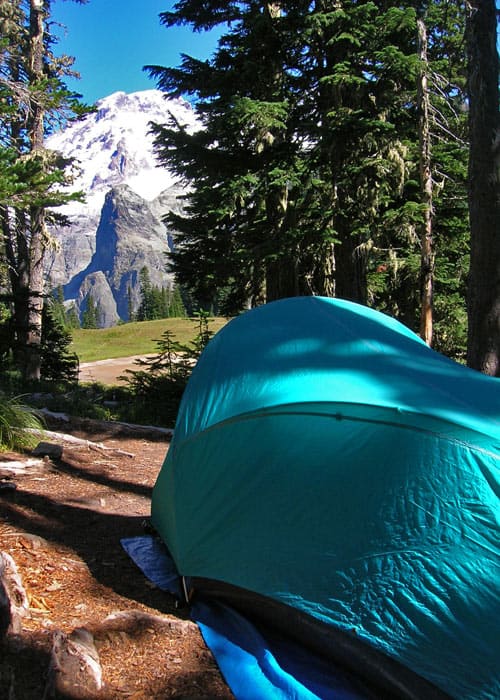
Continue north on the Wonderland Trail making a short climb before reaching a small saddle beneath Aurora Peak. Here another unmarked trail veers rights-this one a very steep scramble trail to the 6,076-foot summit of Aurora Peak. Klapatche Park is just head reached by gently descending through flowering meadows. At 10.7 miles reach a junction with the St Andrews Creek Trail (an alternative approach from the West Side Road) at the shallow meadow-surrounded Aurora Lake in gorgeous Klapatche Park.
The inviting campsites are located on a small wooded knoll just above the lake. A spring just to the east of the lake (which sometimes runs dry by late season) provides good drinking water. Set up camp and await the light show on Mount Rainier. Aurora means dawn in Latin-and watching reflections in the lake of dawn’s early light dancing upon the glaciers of Rainier is stunning. But the evenings are even grander! Indeed one of the most enchanting spots along the Wonderland Trail!
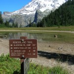
NOTE: Overnight permits are required and can be acquired by making a reservation or in person at the Longmire Wilderness Information Center (360) 569-4453; www.nps.gov/mora. Special rules: No Fires-use camp stove. Dogs prohibited.
Trailhead directions: From Ashford park entrance, continue east 1.0 mile turning left onto Westside Road. Then continue 3.3 miles to road gate and trailhead.
– Craig Romano, Visit Rainier Hiking Expert
Waypoints
| Starting Point: 46.779967, -121.885133 | |
| Notable Waypoints:
Trailhead: N 46° 46′ 47.88, W 121° 53′ 6.48 |
|