| Area: Chinook Pass |
Hike Type: Dog-friendly | Pass: No Pass Req |
| Distance: 3.68 mi RT | Duration: 2.5-3 hrs | Difficulty Level: Moderate |
| Elevation Start: 4,314 | Elevation End: 5,379 | Elevation Gain: 1,080 |
| Snow-Free: June – Sept |
-
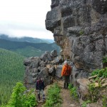
- switchbacks

-
- views1

-

- a the lookout

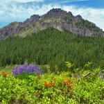
Everyone loves fire lookouts and what’s not to love? On a clear day, the scenery from these historical cabins in the sky defies description with views of peaks in every direction, glittering lakes, the silver squiggle of rivers, the silence broken only by the croak of ravens and the play of light on it all. Add wildflowers and you’ve got it all. On a weekday you might even have the Kelly Butte lookout to yourself, just you and the elements and that’s plenty. Peer inside to a tight but cozy interior with a bunk, stove, and implements – imagine being inside watching a storm march across the sky, the silence broken by the boom-box of thunder and the rattle of rain on the windows.
This hike had been on the list to do for quite some time so what took us so long to get there? The need for a high clearance vehicle. So when a friend with four-wheel drive invited us on this hike, we were eager to go.
We started from the trailhead parking area (4,314 feet) designated with a new trail sign for Kelly Butte and walked the road 0.7 mile to the obvious trail (right). We enjoyed the shady, wild strawberry-lined road, a nice introduction to what’s ahead. Walking the road also gives you a chance to stretch your legs before tackling the short but steep climb to the lookout.
The lookout was originally built in the 1920s, then replaced in 1950. The lookout fell upon hard times, including vandalism – but has since been restored by the Forest Service, Washington Trails Association (WTA) and other volunteers.
The trail has also been tamed – in the past the trail shot up a rocky gully and hikers used a rope to get over some of the tight spots. Though the trail is still steep, it is user-friendly and entices hikers to the lookout. As you climb, the towers of rock and outcroppings daubed with wildflowers are worth slowing down for – look for bear grass, Indian paintbrush, penstemon, arnica, columbine, lupine, phlox and more during the summer months.
Our friend said we might see mountain goats; he’s hiked and skied to the lookout for some 20-plus years and knew where they hung out. Though we crossed our fingers, conditions were not conducive for spotting goats or distant views, as it was a foggy day. We hoped the mist would burn off when we reached the lookout as the views from there are legendary.
Even without views we were enchanted with the twists and turns of the trail as it threaded its way through the steep labyrinth of rocks and outcroppings. As the trail leveled off, we hit snow though not enough to obscure the trail. In what seemed a short time the ghostly shape of the lookout materialized through the fog. A stone staircase leads up to the deck of the handsome lookout (5,379 feet).
We were only able to peer inside as the lookout was locked. In the chilly fog we’d been anticipating lunch inside the lookout so we lingered only long enough to take a few photographs. The fog still clung to the mountain as we started down.
On our way down we ventured cross-country a ways toward an outcropping where our companion had often seen goats in the past. There were no signs of goats today – perhaps like hikers, they prefer views too.
We lingered there watching the silent movie of mist, parting at times to reveal a very green valley below. This was an enchanted setting below the flowery meadows with scattered snags; there was nary a sound save for our hushed conversation. There’s something about fog that almost compels us to whisper in these places. A loud voice in such an ethereal setting can feel like an assault.
We hiked back to the trail and continued to the car. Our emotions were mixed as the mist thinned, occasionally enough for glowing views of the foothills and logging roads below. The clouds were too high for views of Mount Rainier and other peaks but when they cleared the foothills glowed as if lit from within by emerald fire; even the logging roads looked like a thread to follow in a fairy tale.
Getting there: From Enumclaw continue east on State Route 410 and about a long mile past Greenwater turn left onto paved Forest Road No. 70. Continue about 7-3/4 miles to gravel Forest Road No. 7030, and then about 8 miles on Road No. 7030 to trailhead parking. Though Forest Road 70 is in good condition, high clearance vehicles are recommended. Hikers with beefy rigs can drive to where the trail starts but there’s no space to safely turn around. Road 7030 is in good shape though narrow with water bars. During the week there may be logging activities.
Additional information: Map: Greenwater, WA – No. 238 or USGS Lester. For additional information call the Mount Baker National Forest (Snoqualmie District, Enumclaw) at 360-825-6585.
– Karen Sykes, Visit Rainier Hiking Expert
Waypoints
| Starting Point: 47.163333,-121.47416699999997 | |
| Notable Waypoints:
Trailhead: N 47° 09′ 48, W 121° 28′ 27 |
|