| Area: Packwood / Randle |
Hike Type: Family-friendly | Pass: Northwest Forest Pass |
| Distance: 9 mi RT | Duration: 4 hrs | Difficulty Level: Easy |
| Elevation Start: 2,750 | Elevation End: 3,150 | Elevation Gain: 400 |
| Snow-Free: Late-May – Oct |
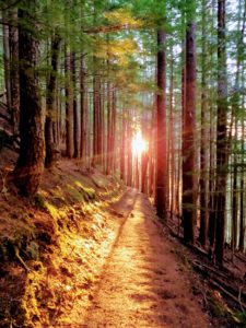
Photo credit Tammy Hall
(Gifford Pinchot National Forest, Goat Rocks Wilderness)
There is a lot to like about Packwood Lake. For starters, it’s one of the earliest trails to melt out in the spring with a “mountain” feel to it. Plus, it’s only a 4.5-mile hike to the lake and you can make a loop via the Pipeline Trail back to the trailhead. Add wildflowers to this hikers’ recipe and you’ve got a delicious treat.
No matter your starting point the drive to the trailhead can be part of the Packwood Lake “experience”. It’s a long drive from Seattle but worth it. We took a scenic route via State Route SR 410 to Cayuse Pass, then Highway 123 to SR 12 and Packwood. Early in the year allow time to gawk at seasonal waterfalls along Highway 123 between Cayuse Pass and Ohanapecosh (you can also get to Packwood from Skate Creek Road).
Once you reach Packwood, find Snyder Road (Forest Service Road No. 1260).
The 6-mile road is well signed and near the abandoned Packwood Ranger Station. The road is paved and generally free of snow by the end of May.
The trail (Trail No. 78) to Packwood Lake was built in the early 1900s for a hydroelectric project. It is mostly in old-growth forest, much of it within the Goat Rocks Wilderness. There were still a few snow patches in May but route-finding was not a problem. The forest was quiet, broken only by the soft hooting of a hidden owl and the gurgle of small tributaries.
In May, flowers begin to appear. We saw bear grass (not yet in bloom) and Canadian dogwood still beaded with raindrops from an early morning shower. In spring look for vanilla leaf, flowering currant, salmonberry, vine maple, Oregon grape, yellow violets, and pinedrops, the tallest saprophyte in our region. There will be a different cast of floral characters bordering this quiet trail as seasons change.
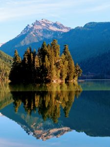
Photo credit Tammy Hall
In about 4.5 miles we reached the lake; before we even had a chance to say “Guard Station” we encountered an agile, elderly fisherman just packing up from a fishing trip. We chatted but were disappointed to hear there hadn’t been a general store or a resort at the lake since the 1980s. We’d been looking forward to a cold drink at the store, as our guidebook, “Best Hikes with Kids” by Joan Burton (published by the Mountaineers) mentioned. However, the only structures at the lake today are the Guard Station and a historical Ranger Cabin under restoration. (The Packwood Lake Guard station is one of the oldest historic buildings within the Gifford Pinchot National Forest. It was built in 1910 to serve as a jumping-off point for horseback patrols of what is now Goat Rocks Wilderness.)
Packwood Lake, two miles long and 0.6 miles wide, was formed over a thousand years ago when a landslide dammed Lake Creek; the Taidnapam people used the lake as a camping and fishing site. Today, the lake’s southern half lies within the Goat Rocks Wilderness. On a clear day, there are views of Johnson Peak; even on a cloudy day hikers will enjoy the view of Agnes Island not too far out from shore. Local lore has it that the island is named after the wife of the man who owned and operated the resort. Locals also call the island Wizard or Enchantment Island.
Follow the trail along the lakeshore to the historical Ranger Cabin, then cross Lake Creek on a sturdy footbridge. A little beyond is the site where a resort once stood. It is also a good place from which to enjoy views of Agnes Island.
Strong hikers can continue on the Packwood Lake trail to campsites and connections to other destinations including Mosquito Lake and Lost Lake.
You can also make a loop back to the car via the multiple-use Pipeline Road Trail (No. 74). The Pipeline Trail starts behind the Ranger Cabin as an old road. The road passes a small dam as it follows pretty Lake Creek to an unsigned junction. Here we turned left onto a rocky trail that became more road-like as we hiked.
The Pipeline trail was more scenic than we anticipated. Moss-bordered freshets trickle down from cliffs and there are logging artifacts to ponder. It is the kind of road that raises more questions than answers (what was that rusty artifact used for anyway?).
While the Pipeline Road Trail makes a pleasant loop it might not be so pleasant on a busy, summer weekend. For a better chance of solitude visit mid-week.
The Packwood Lake trail is open to hikers and equestrians; mountain bikes, motorcycles, and ATVs are prohibited. The Pipeline Road Trail is open to hikers, equestrians, mountain bikes, motorcycles, and ATVs.
The loop is 9 miles with about 400 feet of elevation gain.
Getting to the trailhead: From Packwood follow US 12 to Forest Service Road No. 1260 (Snyder Road) and continue 6 miles on paved road to the trailhead. Use Green Trails map no. 302 Packwood.
– Karen Sykes
Waypoints
| Starting Point: 46.60758723714862, -121.57517910003662 | |
|
Notable Waypoints: Trailhead: N 46° 36′ 28 W 121° 34′ 31 |
|
Q: Can I forage for mushrooms along the trail?
A: Yes, for personal use you can. You may find Bear’s Head Tooth aka Hericium americanum in October. Please use extreme caution when foraging for edible mushrooms. Remember, edible wild fungi must be cooked prior to consumption.
Q: Do you have any additional recommendations on where I can get information on Packwood Lake?
A: You betcha. Check out the trip reports on the Washington Trails Association website. You can also contact the Cowlitz Valley Ranger Station (360) 497 1103
Q: Can you hike the Packwood Lake trail in the winter season?
A: Conditions may vary from winter to winter. Some hikers have reported wanting poles and microspikes to help with sections of ice and snow along the trail in the winter. You may find the winter trip reports logged by WTA hikers to have helpful insights.
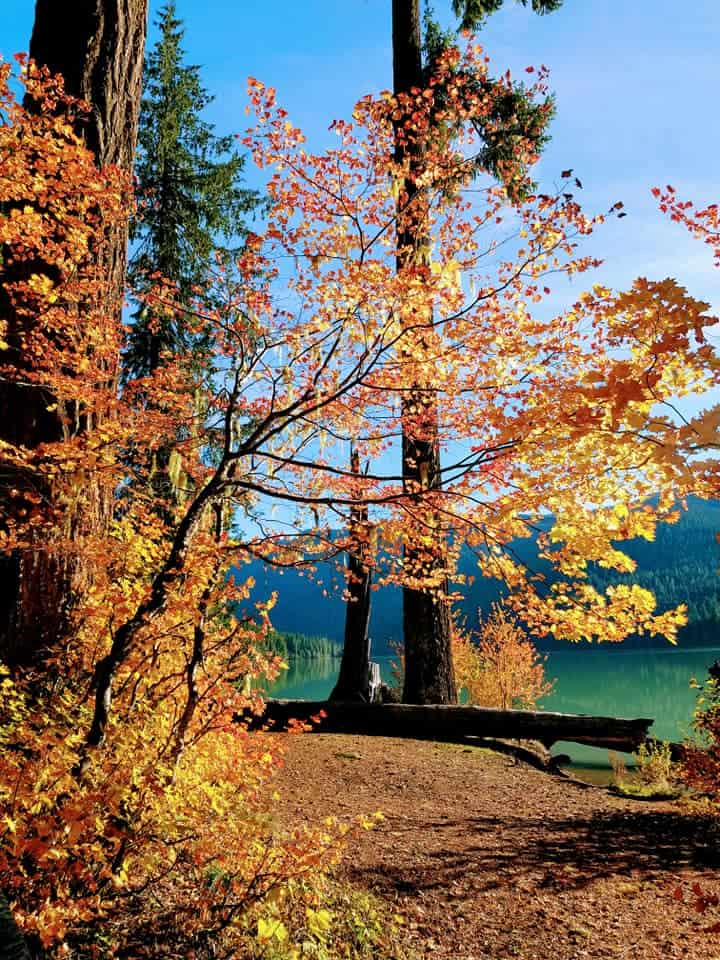
Photo credit Tammy Hall