| Area: Packwood / Randle |
Hike Type: Dog-friendly | Pass: No Pass Req |
| Distance: 6.5 mi RT | Duration: 3.5 hrs | Difficulty Level: Moderate |
| Elevation Start: 844 | Elevation End: 2,965 | Elevation Gain: 2,121 |
| Snow-Free: June – Mid-Nov |
-
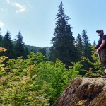
- viewpoint

-
- onthetrail
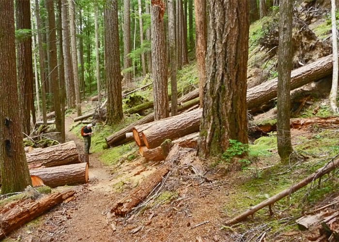
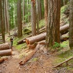
It’s a good thing we didn’t read trail reports from 2010 before checking out this trail – otherwise we wouldn’t have gone and we’d have missed out on a sweet hike. Last year the spur road to the trailhead was inaccessible due to washouts and the trail almost impassible due to numerous blow downs and landslides. Fortunately, since then Gifford-Pinchot National Forest has worked miracles – blowdowns have been recently cleared and there were no difficulties getting to the lake.
We’d wanted to check out trails near Packwood – an untapped resource for many hikers who live in Seattle. One of our methods in finding “new” trails to hike is to study maps and find trails that don’t appear in mainstream hiking guides. This is how we found the Glacier Lake Trail No. 89 in the Goat Rocks Wilderness and with a little more online “sleuthing” this trail seemed worthy of a visit (Packwood is well within driving distance of Seattle).
Getting there was easy enough and per information on the Gifford-Pinchot National Forest website we parked below FS Spur Road No. 2110 on the shoulder of FS Road No. 21 where we began the hike. The actual trailhead is at the end of the -mile spur – in other words you can’t drive to the trailhead. The washouts have necessitated closure of the spur.
Shortly after hiking the spur we came to the washouts that caused the road closure. There is only room for one vehicle at the closure and no turnaround. That’s not a deal-breaker for hikers as the road walk is only mile – plus, that gave us a chance to warm up.
Just past the washouts you’ll come to the signed trailhead – here you can see where hikers used to park before the spur was closed. There is also a box with self-issued permits to enter the Goat Rocks Wilderness (these are required) so be sure to fill one out.
The trail starts off with a descent toward Glacier Creek and is mostly in old-growth forest with several ups and downs, some of them steep. Trekking poles would come in handy for some of the steep sections. While the steep stretches are not exposed it’s easy to skid on the hard-packed dirt/pebble surface. Other than that, the trail is in good condition and we appreciated the work of the Forest Service in clearing the trail and keeping it open.
Though the hike is short we’d rate it as a moderately strenuous hike – per the GPS the elevation gain was greater than in guidebook hike descriptions and online hiking-related websites.
Glacier Lake was formed because the surrounding mountains collapsed long ago; one theory being that it was caused by an earthquake. As the debris filled up the canyon, the lake formed behind it.
This is old-growth forest at its finest with plenty of vine-maple all along the trail and at the lake, already in early August with a tinge of fall color. As you approach the lake, mossy boulders begin to appear and the anticipation of getting to the lake begins to build. The trail winds through a mossy chaos of jumbo-sized boulders where the lake first comes into view. Some hikers make this their turnaround as they can see the lake and the sun-warmed boulders provide a pleasant setting.
The lake is not much further. Past the “picnic” rocks the trail continues, skirting the boulder field. At the lake the water was a little high and there were not many places to sit – there are a couple of primitive campsites with partial views of the lake (these were not occupied). Word has it that fishing is good – the lake is reported to have trout in abundance – a Washington state Fishing License required.
At one time according to trail guides, a trail went around the lake (the lake is huge) but what tread we found was overgrown and appears to show little use so we didn’t pursue it. Note the huge cedar tree with low-hanging branches that frame the lake at the second campsite – this, one of the largest cedars we’ve seen.
Solitude is practically a given – we only encountered two other hikers. This seems to be a seldom-hiked trail. It would also make a great fall-color hike.
On our way home we stopped at Packwood to visit the White Pass Country Museum. The revered building once served as a school (built in 1939) but when the mill closed in Packwood so many families moved away that the school also closed. There are marvelous displays, artifacts and photographs of what life used to be like in Packwood and nearby settlements, including the interior of an old classroom complete with grade-school texts.
We spent a couple hours at the museum viewing the exhibits and talking to the nice folks that volunteer time to keep the museum open. This is one of the most interesting museums we’ve visited so make it a point to stop by (a small donation is requested).
Getting there: From Packwood drive three miles (west) on US 12 to Forest Service Road No. 21 (signed), drive about 5 miles to spur 2110 (signed Glacier Lake) on the left. Road No. 21 is fine for passenger cars. The map is Green Trails No. 302 Packwood WA.
Additional information: Wheels of any kind are prohibited, no facilities at the trailhead. For additional information/conditions call Gifford-Pinchot National Forest (Cowlitz Valley Ranger District) at 360-497-1100. For information on purchasing a fishing license refer to the Washington Department of Fish and Wildlife: www.wdfw.wa.gov. To learn more about the White Pass Country Museum call 360-494-4422 or visit their website: www.whitepasscountrymuseum.org.
– Karen Sykes
[divider ]Waypoints
| Notable Waypoints:
Parking: N 46° 32′ 42, W 121° 37′ 27 |
|