| Area: White River |
Hike Type: Glacier views | Pass: Natl. Park Pass |
| Distance: 3.0 mi RT | Duration: 1.5 hrs | Difficulty Level: Easy |
| Elevation Start: 4,306 | Elevation End: 4,829 | Elevation Gain: 523 |
| Snow-Free: July – Oct |
-
- on the trail

Hiking Tip: bring your binoculars.
It was like seeing an old friend again after being away for five years. The Emmons Moraine trail is accessed off the Glacier Basin Trail, located out of White River Campground. It was a hike we did a couple of times each year with friends and family because of its spectacular views as well as being easy and not too long. Then the flooding rainfall of November 2006 took that trail away.
The destruction on the first two-thirds of the 3.1-mile trail to Glacier Basin was massive. A make-shift trail was created in 2007, but it was very difficult to negotiate through the many log jams, landslides and long stretches of river rock. There was no way to cross the river or create a trail in the soft-dirt hillside to get to the moraine. In 2010, a new trail to Glacier Basin was built above all the destruction, To our delight, as we started a hike to the Basin, we saw that the Emmons Trail was back again and couldn’t resist going there for lunch instead.
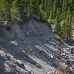
This is a great trail to view the Emmons Glacier, one of the 25 glaciers on Mt. Rainier, and the largest in the contiguous United States. The top half of the glacier is a huge field of giant ice towers and deep crevasses, while the bottom half of the glacier is covered in debris from a massive rockfall in 1963, originating from Little Tahoma Peak. Although it may look like only dirt, there are many giant boulders the size of a one-car garage. This debris insulates the ice of the glacier beneath it, so as other glaciers here and around the world are retreating, this one is actually advancing, albeit at a slower rate than in the 1980’s.
The Moraine itself is an awesome result of the power of ice. The deeply cut valley is littered with massive boulders left by the ice as it retreated at the end of the last Ice Age. Scattered around the moraine are small lakes with a unique sea-foam green color. This is caused by the sun reflecting off glacial sediment suspended in the water. Here the White River begins its journey down the mountains, through the valleys, to Puget Sound.
Glaciers are very dangerous forces of nature. Often caves develop in the ice where the river originates. The next time you visit, the ceilings of those caves you saw the previous time may have collapsed. Rocks and ice are always falling from the face of the glacier. Another danger concealed in the glacier is hidden pockets of water that are always trying to escape the ice. Sometimes these can be very large and cause a flash flood into the moraine without warning. You must always be aware that the ice is moving, changing, and unpredictable and can be very dangerous. The high ground is the safest place to be. On this hike, binoculars are a must to see the powerful beauty of the ice.
You can find the Emmons Glacier trailhead in the White River Campground, just down the road from the White River Entrance to Mt. Rainier Nat’l Park. There is a parking lot for hikers and climbers on the left side of the road just inside the campground. The Emmons Moraine Trail starts at the Glacier Basin Trailhead on the west end of the campground (Loop D). The new trail travels above the old one and has a slightly steeper incline – not quite as easy as it was. For the Emmons Moraine, take a left at the junction about a mile in and continue along the moraine for another half a mile. (The Glacier Basin Trail continues on 2.2 mi. from the junction.) The hike is about an hour round trip, but you will linger much longer.
White River Campground is the source of several wonderful trails, but you may just want to spend the day along the river or walk the “loops” of the campground. The campground itself is full of interesting history.
– Mary Janosik, Visit Rainier Hiking Expert
Waypoints
| Starting Point: 46.90302, -121.62991999999997 | |
|
Notable Waypoints: Trailhead: N 46° 54′ 6″, W 121° 38′ 46″ |
|