| Area: Westside Road |
Hike Type: Thigh-burner | Pass: Natl. Park Pass |
| Distance: 13.7 mi | Duration: 8 hrs | Difficulty Level: Strenuous |
| Elevation Start: 3,411 | Elevation End: 5,644 | Elevation Gain: 3,141 |
| Snow-Free: Mid-July – Mid-Oct |
-

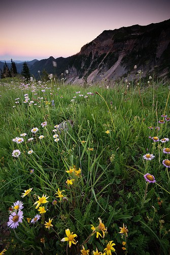
- a emerald ridge2 tm
-
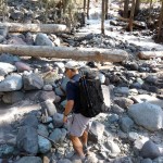
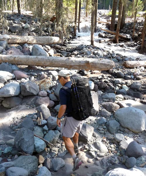
- a in tahoma creek
-
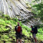
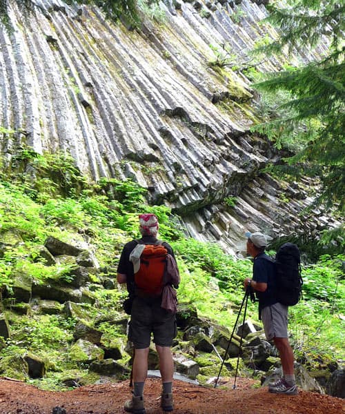
- andesite columns
-
- a emerald ridge tm

Want to see nature in the raw?
Hike to Emerald Ridge via the mercurial Tahoma Creek Trail. This approach begins on the West Side Road, which is closed to traffic at three miles past its junction with the Nisqually-Paradise Road. The park thought the closure necessary because of recent outburst flood activity from the South Tahoma glacier. These outbursts trigger road-damaging debris flows and the possibility of more activity in the future is simply too great. The closure adds mileage to what used to be considered moderate hikes but don’t let that stop you from enjoying some of the most spectacular places in the park.
Hikers can make a challenging 13.7-mile loop via the unmaintained Tahoma Creek Trail, the Wonderland Trail and the South Puyallup Trail. For a variation hikers can skip Tahoma Creek altogether, by hiking or bicycling up the road to the South Puyallup Trailhead at Round Pass and starting from there. Round Pass is a tad under four miles from the West Side Road closure, a longer but easier approach.
We opted for the Tahoma Creek approach; from the gated road it’s a little over a mile to the Tahoma Creek Trailhead. Look for the trail at the end of a switchback on the road, marked with a trash barrel on the right-hand side.
A soon as you set foot on the trail a “trail not maintained” sign appears; keep going, this is the beginning of the Tahoma Creek Trail.
The Tahoma Creek trail was also so badly damaged that the park had no choice but to “abandon” this trail in principle, at least until (or if) there are funds available for repairs. We knew part of the trail was in bad shape but were ready for an adventure; we were not disappointed.
Parts of the trail are missing altogether. Where tread is missing the route goes out onto river bars and is marked with flags or cairns; this is a sketchy stretch where finding the trail can be a challenge. Hikers with sharp eyes should be able to follow the marked route though conditions can change, especially when winter storms arrive. Then the trail may not be safe for hiking; check conditions with the park before you go. Late summer, when stream levels are low, is the best time to hike this trail.
In early fall, the Tahoma Creek was well within its banks though the damage from recent floods was sobering uprooted trees, piles of boulders, debris, and listing trees were scattered among the braided channels.
The trail re-enters the forest then ventures out onto the river bar again a couple of times before it finally climbs away from the river for good. Other than a couple of deteriorating footbridges the rest of the Tahoma Creek trail is in decent shape, the forest unscathed.
Shortly past a small waterfall we reached the junction with the Wonderland Trail (N 46° 48′ 16″, W 121° 50′ 54″). Here hikers bound for Indian Henrys Hunting Ground would turn right on the Wonderland Trail and cross Tahoma Creek on a suspension bridge.
Take time to visit the Tahoma Creek suspension bridge a few steps away.
At first glance the bridge may look intimidating but is safe; a sign cautions that hikers cross one at a time to keep the bridge from swaying. On my previous visit, I watched a woman with a huge backpack cross the suspension bridge chanting the Lord’s Prayer the entire way. After looking at the bridge we returned to the junction and continued on the Wonderland Trail toward Emerald Ridge.
After the gymnastics of wrestling with Tahoma Creek, we were ready for easier terrain though the next section of the Wonderland Trail was rocky, steep, and overgrown with thimbleberries. The switchbacks relented as the trail contoured between cliffs and a moraine with views of Saint Andrews Rock, Glacier Island, and Mount Rainier. Look for Tokaloo Spire rising above the glaciers. Bring a map to help you identify them (Green Trails, Mount Rainier West, No. 260).
The trail climbs to a saddle (5,622 feet) on Emerald Ridge, a good turnaround for a day hike though you can continue on the Wonderland Trail to a high point (5,644 feet) or as far as time and energy allow. From the saddle, it’s about 4.1 miles back to the car if you hike back the way you came or 8.2 miles round trip.
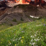
Look for mountain goats; we spotted two perched on a grassy knoll above us. In September displays of late summer, flowers dotted the rich green meadows of aptly named Emerald Ridge.
If making the loop continue on the Wonderland Trail as the trail descends, narrowing to follow Emerald Ridge above the rubble of the Tahoma glacier; here there are spectacular views of the Tahoma glacier, the South Tahoma glacier and the Puyallup cleaver.
As you peer over the edge into the kaleidoscope of colors from glacial debris you may feel you have stepped onto the moon. You may find it hard to distinguish between the snout of a glacier and a moraine or where one glacier begins and another ends. Above the moraines the Tahoma glacier splits in two to spill ever so slowly over a dark outcropping, the blue-green glacier slashed with crevasses and streaked with grit.
The Tahoma glacier is held in place by the Tahoma cleaver and the Puyallup cleaver; the Puyallup cleaver hides the Puyallup glacier from view until you descend to lower elevations on Emerald Ridge. As we descended toward the South Puyallup trail we noted huge boulders perched on the edge of the moraine; it’s a gorgeous mess.
Gradually hardy evergreens replaced the delicately balanced boulders; sedges and wildflowers including harebells edged the path with a flicker of Indian paintbrush now and then. The trail descends more steeply, switchbacking through the ever-deepening forest.
At the next junction (4,267 feet) we left the Wonderland Trail (N 46° 48 ’49”, W 121° 51′ 51); here the Wonderland Trail crosses the South Puyallup River on a bridge and continues to Saint Andrews Park, Klapatche Park and beyond.
Here we proceeded on the South Puyallup trail toward Round Pass and the West Side Road. Shortly past the junction, we passed South Puyallup Camp with designated campsites. Just past these campsites, we stopped to marvel at cliffs of andesite columns formed by geologic processes. We dubbed these remarkable formations Mount Rainier’s Hardware Store, the tubes of once-molten rock reminded us of giant 2x4s. Some of the columns are so gracefully curved others liken them to spaghetti in a spaghetti maker. However your eye interprets these formations, we guarantee you will be awe-struck.
We continued on the South Puyallup trail 1.6 miles to the Round Pass trail (N 46° 48′ 23″, W 121° 53′ 27″, 3,539 feet) to Round Pass (N 46° 48′ 06″, W 121° 53′ 53″, 3,886 feet) on the West Side Road (about 2.2 miles from the junction with the Wonderland Trail). The Lake Louise and Gobblers Knob trails also begin at Round Pass.
Since it was almost a four-mile road-walk from Round Pass back to the car, we stopped for a break and pondered the Marine Memorial Airplane Crash Monument, which honors marines who lost their lives there in 1946. The monument lists them by name and reads “In memory of the 32 marines who lost their lives in an airplane crash on December 10, 1946 while under orders and en route from San Diego California to Seattle, Washington and who now lie on South Tahoma Glacier.”
If you make the loop, hike with friends; though you may dread the road walk lively conversation makes the miles fly, if not your feet.
NOTE: The West Side Road closes for the season on November 15.
– Karen Sykes, Visit Rainier Hiking Expert
Waypoints
| Starting Point: 46.7949511841589, -121.88164293766022 | |
|
Notable Waypoints: Tahoma Creek Trailhead: N 46° 47′ 42, W 121° 52′ 54 |
|