| Area: Stevens Canyon |
Hike Type: Mountain views | Pass: Natl. Park Pass |
| Distance: 11.8 mi RT | Duration: 6-7 hrs | Difficulty Level: Strenuous |
| Elevation Start: 3,050 | Elevation End: 5,900 | Elevation Gain: 2,850 |
| Snow-Free: July – Oct |
-
- Trail eventually descends the divide for Indian Bar

-
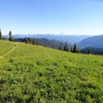
- Approaching one of the many open knolls along the Cowlitz Divide

-
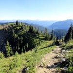
- Trail travels up and down along the Cowlitz Divide

-
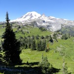
- Cowlitz Valley and Mount Adams in the distance from Cowlitz Divide

Wait for a clear day when you have a lot of time to do this strenuous hike to a truly legendary place — Cowlitz Divide. The hike provides a glorious experience and spectacular views while you trek for miles along the top of a ridge. Few ridge walk opportunities anywhere offer you so unique an adventure. Most hikers would give up as much as a ton of fudge brownies for such a chance.
Drive the Stevens Canyon Road west from the Stevens Canyon entrance 10 miles on Highway 123 to Box Canyon parking area, elevation 3,050 ft. The trailhead is across the road from the parking area, just east of the Box Canyon Nature Trail.
Appreciate the fact that the moderate path eases you into the hike, giving you time to gain your pace and wind for the first mile to a footlog across Nickel Creek. In another mile is a small creek. If you have extra water containers or jugs, you’d be wise to fill them up here, as this is the last water before Indian Bar, an overnight camping destination requiring a two-day trip. Instead, your destination is a stunning overlook at a 5,900-foot knoll on Cowlitz Divide, where you can look down on what would be a two-mile descent to Indian Bar.
From that small creek, the trail ascends gradually towards Cowlitz Divide, crossing a Nickel Creek tributary, then switching back and recrossing the creek. The way keeps climbing and climbing for about 2 miles, gaining considerable elevation about 1,000 ft to Cowlitz Divide and a junction with Olallie Creek Trail at 2.9 miles (from the road). Go left at the junction and follow the Wonderland Trail as it rises along the apex of Cowlitz Divide.
You’ll love moving on Cowlitz Divide. If you’re like most hikers, it’s hard to give up elevation once you’ve achieved it. That’s why you’ll keep going and going as the trail continues through forest for another mile, ascending steeply at times over the top of a 5,400-foot summit at 3.9 miles. Your steps will stay on an upward pace through thinning forest past a 5,600-foot peak on the left at 5.1 miles. Yes, you’re still rising further.
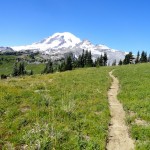
By now you’ve been getting glimpses of Mt. Rainier though the trees and meadows have been growing larger. That teases you on. The way continues up the ridge for another 0.8 mile to a wide knoll, at 5,900 ft and 5.9 miles from the trailhead. That’s when Mt. Rainier is completely revealed, showing itself in its entire splendor. What a moment! What a view! Look around you. Besides, Rainier, there’s Bald Knob and Shriner Peak to the southeast. Below lie the Ohanapecosh River and enchanted Indian Bar, an outstanding alpine campsite and meadow.
You’ve gone as far as you’re going on this day, and have a long way to return. The knoll atop this grassy portion of the ridge is a perfect spot for a picnic, and, of course, your turnaround. Take plenty of photos to capture forever a memorable outing to an invigorating and magical place.
Your feet will be talking to you after the end of this serious hike. So…take time to soak them in Nickel Creek near the end of your return trip. They deserve it.
– Karen Sykes
Waypoints
| Starting Point: 46.760556, -121.627778 | |
| Notable Waypoints:
Trailhead: N 46° 45′ 38, W 121° 37′ 40 |
|