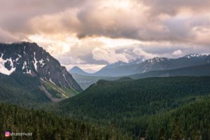
View from the trail leading to Carter Falls courtesy Instagram User @shutterhold
Semi-hidden Carter Falls is especially enjoyable on a hot day as the Nisqually River Trail leading to it, is through sheltered old-growth forest beside the Paradise River.
This 53 foot high falls is but one of several along the Paradise RiveTrailile Carter Falls is not the most spectacular of waterfalls, it is more than pretty enough to command your attention and is a refreshing sight on a summer day. One distinguishing feature is a pour spout (think creamer!) that funnels the waterfall into a symmetrical column.
Carter Falls was named between 1889 and 1895 for Henry Carter, a guide who built the first trail to the Paradise Valley.
Height: 53 feet | Form: Plunge | Number of Drops: 2
Source Stream: Paradise River | Access: Moderate Hike
Location: 46.76474 N, -121.76995 W
Directions: Access the Wonderland Trail across from Cougar Rock Campground, located eight miles east of the Nisqually entrance to the park. Hike the trail eastward 1.3 miles to the falls.
Q: How far is Carter Falls from the Christine Falls Bridge?
A: It’s approximately 3.4 miles from the Carter Falls to the Christine Falls Bridge.
Q: Are dogs allowed at Carter Falls, can I hike there with my favorite hiking pup?
A: No, dogs are not permitted on the trails at Mount Rainier National Park. Dogs (on a leash) are allowed on paved roads and parking areas, basically, anywhere you can take a vehicle. Click here for the official Mount Rainier National Park pet policy. We do have a travel guide designed for people traveling with their dogs. The free resource lists all of the dog-friendly trails in the region, yet outside of the national park. Click here for a free copy.
Q: Can I fly my drone over Carter Falls?
A: No, drones are not permitted in Mount Rainier National Park.
Q: If I want to hike and drive to see as many waterfalls as I can in one day, what’s a reasonable itinerary? I’m not afraid of a long day or to hike the miles.
A: Start with the hike at Silver Falls along the Silver Falls Loop. This trail requires a 2.7-mile hike. Next, you’ll want to drive to Narada Falls to see the Narada waterfall which is easily viewed from the parking lot without requiring a hike. There is a trail to take you close to the bottom of Narada Falls. Once you’re done viewing Narada you’re very close to Ruby Falls. The upper portion of the Ruby Falls can be seen from the road, and the lower portion can be seen by walking 100 yards along the Narada Falls trail. Next, you’ll drive to the Carter Falls trailhead. The trek to see Carter Falls requires a 1.3-mile hike. Want more waterfalls? You can drive to the Comet Falls trailhead. Comet Falls requires a 1.6-mile hike. If you’re up for more of a hike, it’s approximately a 2-mile walk from Comet Falls to Christine Falls. Just past the Comet Falls trailhead to a small parking area. A short set of stairs leads to the falls overlook to see Christine Falls. After viewing Christine Falls we recommend calling it a day. Consider enjoying a hearty meal at the National Park Inn and relaxing for the rest of the night. You will have driven about 32 miles, and hiked just under 8 miles! Click here for a Google Map of this itinerary.
Silver Falls > Narada Falls > Ruby Falls > Carter Falls > Comet Falls > Christine Falls
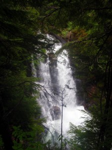
Nearby Carter Falls © Ken Campbell