| Area: Sunrise |
Hike Type: Thigh-burner | Pass: Natl Park Pass |
| Distance: 9 mi. RT | Duration: 4-6 hrs | Difficulty Level: Strenuous |
| Elevation Start: 5,228 | Elevation End: 7,828 | Elevation Gain: 2,600 |
| Snow-Free: Mid-July – Mid-Oct |
-
- steamboat prow

-

- hikers third burroughs
-
- a closer view of the winthrop glacier
-

- view above frozen lake from first burroughs trail
-
- en route to burroughs

The hiking season at Sunrise is short and sweet – the road to Sunrise closes when significant snow falls and at an elevation of 6,400 feet snow can occur just about any time of the year. Plus, trails at Sunrise are slower to melt out than other trails at Mount Rainier (trails at Paradise are also slow to melt out). That’s reason enough to scurry to Sunrise when conditions are favorable.
On the first day of September, the sun was shining and temperatures were perfect for hiking at Sunrise. The hike to Burroughs Mountain starts to the right of the restrooms at Sunrise. You may want to avail yourself of that restroom – there are no facilities along the trail and privacy is nigh impossible to come by. From there we hiked the spur to Sourdough Ridge Trail, turning south (left) at the T-junction facing Mount Rainier.
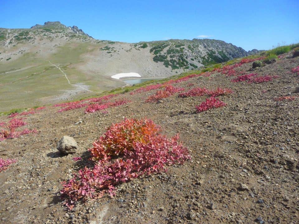
In early September Sunrise vacillates between late summer/early fall; alpine asters and ragged hellebore bordered the Sourdough Ridge trail and reddish clumps of sand dock hugged the ground. Though the sun was warm winter waits in the wings as golden-mantled ground squirrels and chipmunks darted about, racing from rock to rock in hopes of hand-outs from hikers (try to resist!).
Past Frozen Lake (the water-supply for Sunrise and off-limits to the public) is a five-way trail junction at 6,760 feet. There trails head to Mount Fremont Lookout, Berkeley Park, Grand Park and Mystic Lake via the Wonderland Trail. From this junction follow trail signs to Burroughs Mountain – junctions are well-signed.
The Burroughs Mountain trail is snow-free though that can change at any time. We know from experience how quickly the weather can change at these elevations; one moment you’re too warm, the next you’re fumbling in your pack for gloves with frozen fingers.
Soon you will pass a junction for the Sunrise Rim Trail (some hikers opt for a loop by starting out on the Sunrise Rim Trail that starts at Sunrise below the Visitor Center and hiking back to Sunrise via Burroughs Mountain and Sourdough Ridge). Study the map for details.
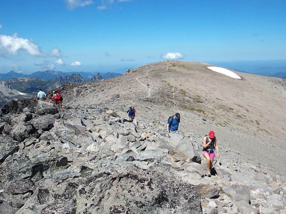
When we reached Second Burroughs at 7,400 feet (a broad plateau scattered with rocks) we took a break. Second Burroughs also provides a handy bench set inside a wind-break made of stones. Many hikers may be content with Second Burroughs, especially when they see how far away Third Burroughs looks in the distance. In addition to hikers you’ll probably be mobbed by ever-optimistic golden-mantled ground squirrels and chipmunks with their bright, sparkling eyes and their tiny, nimble paws. Feeding them is discouraged.
From Second Burroughs getting to Third Burroughs is considered a “grunt” by those who’ve hiked there before.
The view of the trail ahead can be discouraging as the trail from Second Burroughs plummets to a plateau before resuming a steep climb to Third Burroughs. Take heart – remember you can always turn around when you’ve had “enough” or conditions warrant.
Much of the trail lies within an unusual tundra-like environment where anything that can grow is dwarfed by the harsh environment. Plants are few and far between and those that do grow hug the ground as they hunker down against wintry conditions. Though this environment may appear to be a dead zone you’d be wrong – if you don’t believe us come back in summer when avalanche and glacier lilies pop up from the melting snow.
Of course the last stretch of the climb to Third Burroughs is the steepest; those last few steps are particularly steep and rocky. Carry on – it’s worth the effort as long as the weather holds.
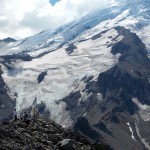
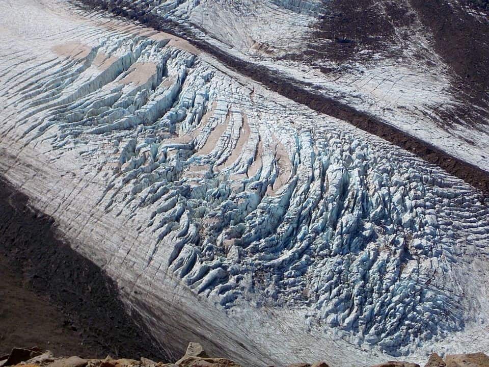
If this is your first hike to Third Burroughs the views of the crevasses on the Winthrop and Emmons glaciers may take your breath away.
There you can look straight down into the deep crevasses of the Winthrop glacier and Steamboat Prow (a rock formation that splits the Winthrop glacier from the Emmons). The Emmons glacier is directly above the prow though on our hike most of the Emmons glacier was under cloud-cover. Look down to the origin of the White River, a mere silver trickle emanating from the snout of the glacier. These views are dizzying and inspirational – Steamboat Prow, the nightmare conglomeration of rotten rock and ice that comprises Little Tahoma. You may even get a glimpse of the icy and wicked Willis Wall and cruel, cunning Curtis Ridge if the clouds allow.
Third Burroughs is far enough for most hikers with several places to settle and no lack of views; we found a niche out of the wind which had become strong enough to almost knock me down at one point.
Though we always dread the climb back to Second Burroughs it’s never quite as tough as we imagine. We paced ourselves and took another break at Second Burroughs as the sun was still warm and there seemed little reason to hurry.
Getting there
From Enumclaw drive State Route 410 (east) to the White River Entrance of Mount Rainier National Park; display the appropriate pass or pay an entry fee. When you get to the junction for the White River Campground continue on the Sunrise Mountain Road to Sunrise, elevation 6,400 feet.
Map: Green Trails No. 209S (Mount Rainier Wonderland Trail)
Additional Information: Call Mount Rainier National Park at 1-360-569-2211 to confirm road and facility status, fees, rules and regulations or check their website for current information:
www.nps.gov/mora/
– Karen Sykes
NOTE: Call the park at 1-360-569-2211 to confirm road and facility status or check the website for current information.
Waypoints
| Starting Point: 46.852439998114484,-121.76726902500002 | End Point: 46.852439998114484,-121.76726902500002 |
| Notable Waypoints:
Sunrise Parking Lot: N 46-54-53 W 121-38-31 (6,400 feet) |
|