| Area: Stevens Canyon Rd |
Hike Type: Scramble | Pass: Natl. Park Pass |
| Distance: 10 mi RT | Duration: 9-12 hrs | Difficulty Level: Strenuous |
| Elevation Start: 3,732 | Elevation End: 6,732 | Elevation Gain: 3,000 |
| Snow-Free: Mid-July – Mid-Oct |
-
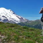
- on the ridge

-
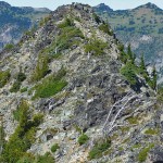
- tamanos summit

-
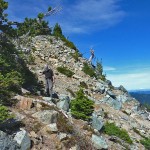
- scramble trail

NOTE: The trek to the summit of Tamanos is a scramble.
If you’re searching for a hike through old-growth forest, one that climbs to lakes surrounded by knee-deep flower meadows and offers views of peaks rising high into the sky, this hike will more than meet your expectations. This trek follows the lovely Owyhigh Lakes Trail before heading up to the ridgeline and summit of Tamanos Mountain at 6,790 feet. Reaching the summit does require scrambling (non-technical climbing) skills, so be prepared when opting for this trek. However, a stop anywhere along the ridge offers majestic sights; you needn’t climb the peak for fabulous views.
True, legendary climber and author Fred Beckey, wouldn’t devote more than a sentence or two to a minor summit like Tamanos though the views from there are anything but minor.
The high country along the trail is magical, take time to enjoy the majestic forest on your way as you begin your trek; this is the forest at its best with huge Alaska cedars and Douglas firs, more than worthy of a passing glance.
After crossing a creek on a footbridge and passing Tamanos Camp (designated campsites), the trail gradually leaves the forest as Owyhigh Lakes and jagged Governors Ridge come into view (left). Here is a good place for a break, lunch or a turnaround.
If you’ve got your heart set on Tamanos Mountain, continue about a quarter mile past the lake to an unsigned junction where a faint path (right; N 46° 51′ 45″, W 121° 35′ 21″; 5, 358 ft) heads uphill through a meadow (the main trail continues to Deer Creek on the Ohanapecosh River). The climber’s trail ascends a steep, still-green meadow with expanding views of Cowlitz Chimneys (left) and better views of Governors Ridge and Barrier Peak above the lakes. Mount Rainier comes into view just below the saddle on the ridgeline.
Take a break at the saddle ( N 46° 51′ 59″, W 121° 35′ 45″; 6,235 ft); that’s a steep climb. Gaze upon the glaciers of Mount Rainier (Fryingpan Glacier above Summerland and Fryingpan Creek). At the saddle you can turn east (left) to an outcropping; ideal for a rest-break or turnaround. For Tamanos, turn right (west) and continue as the path threads its way around dense stands of evergreens and rock formations for views of Panhandle Gap. In the Chinook Jargon, Tamanos translates to “spirit and power.” Bring a map to help identify other peaks and points of interest.
Though wildflower displays are beginning to fade in September, there were still many in bloom, especially in meadows; magenta paintbrush, valerian, bistort, lupine and more. The path grows a little airy as it climbs over or around high points; you will soon see a large, black outcropping with shrubby evergreens at its base; this is the false summit (N 46° 52′ 14″, W 121° 35′ 47″; 6,732 ft). If you feel uncomfortable, any of the rock outcroppings make good turnarounds; otherwise continue on a faint path (left) on loose rock as it drops then climbs to get around the false summit. There the summit comes into view but you’ll need to follow the path a little further to get there. While the summit is not large, it is flat and large enough to accommodate a small party of hikers. In addition to Mount Rainier and Little Tahoma, there are views of Mount Adams, the Goat Rocks (to the south), Mount Baker (north), Mount Stuart (northeast), and even Mount Rainier’s highway to Sunrise.
Getting to the summit is not for hikers without scrambling experience or if you are uncomfortable with exposure. Heading to the summit, exercise caution where the rock is loose. Turn around at any point you feel uncomfortable; keep in mind – the views from the ridge are just as good as they are from the summit.
Back at the junction, we continued toward Deer Creek for another mile or so. We passed more lovely meadows, small tarns and views of the Cowlitz Chimneys. If you keep going you’ll eventually end up at Deer Creek off Highway 123. We turned around when the trail re-entered the forest and began to steeply descend.
Getting to the trailhead: The Owyhigh Lakes trailhead is located a couple miles past the White River entrance of the park, on the Stevens Canyon road (just past Shaw Creek). Park on the right-hand side of the road – the trail begins across the parking area.
For additional information on fees, rules and regulations, current conditions, weather, reserving campsites call Mount Rainier National Park (360-569-2211) or visit their website at www.nps.gov/mora. The recommended map for Mount Rainier National Park is Green Trails (Mount Rainier Wonderland Map 269S).
– Karen Sykes, Visit Rainier Hiking Expert
Waypoints
| Starting Point: 46.89077068682885, -121.59715260043946 | |
| Notable Waypoints:
Trailhead:N 46° 53′ 27, W 121° 35′ 49 |
|