| Area: Stevens Canyon | Hike Type: Off the Beaten Track | Pass: Natl. Park Pass |
| Distance: 8.4 mi RT | Duration: 5-7 hrs | Difficulty Level: Strenuous |
| Elevation Start: 2,400 | Elevation End: 5,834 | Elevation Gain: 3,434 |
| Snow-Free: July – Oct |
-

- lily

-
- rainier hq

-
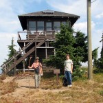
- a shriner peak lookout

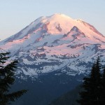
Ascending a dry, dusty trail to high panoramic views of Mt. Rainier and the Ohanapecosh Valley as well as distant views of the Cascades north and south, you can draw a sigh of relief and relax at the top of Shriner Peak, where a weathered, brown lookout tower has stood for more than 70 years. A lake in a meadow far below is the summer home of a large herd of elk. You’d think more people would climb to this site, but it’s hailed as one of the loneliest trails in Mount Rainier National Park. It doesn’t get any respect. But it should.
The trailhead is located along Highway 123, about 4 miles north of the Stevens Canyon entrance. The parking area is on the west side of the road, about 1/2 mile north of Panther Creek bridge. The trail is on the east side of the road, almost hidden from sight. Elevation here is 2,400 ft.
This trail is reasonably direct, with few switchbacks. The lower part of the route winds its way through tall Douglas firs, cedars, and hemlocks. The route parallels Panther Creek. Reaching a luxuriant patch of berries, the path soon breaks into the hot sun, going up through an old burn with trees too small to offer much shade.
In 2.5 miles, the trail attains a ridge top. While there’s still no shade and you’re going through your water supply rapidly (bring lots because there’s no place to refill), here’s a treat: Your first great view of the east side of Mt. Rainier in all its glistening, white glory. Eventually, you briefly drop into a high basin, and then quickly begin an ascent up the final stretch to the summit. If you’re doing this hike in the fall, you might just be able to savor the fall colors of vine maples, mountain ash, and berry bushes. It will take your mind off the hotness and steepness.
After several hrs of trudging continually upward, the trail turns rocky — making for some treacherous footing. Just be careful. The sun is still beating down on you, of course, but you’re getting near the end. Finally, within the last 1/4 of a mile to the summit, you get your first view of the lookout.
Walking across the grassy pinnacle, you reach the two-story tower, built in the 1930s, but infrequently staffed these days. Climb to the catwalk that encircles the tower and look inside. See the bed, fire finder, gas stove, and table. Enjoy the view: Little Tahoma, Mt. Rainier, Cowlitz Divide, Sourdough Ridge, Mt. Adams, the Goat Rocks, and Mt. St. Helens. And much more in between and beyond.
You’ve earned a rest (hopefully, you’ve taken some breaks intermittently throughout the hike) and a lunch break. You’ve met the challenge of a strenuous hike and reaped the rewards of unbelievable beauty — a panorama that’s hard to match anywhere in the Cascades, let alone other places in the United States.
Ponder this as you return: Perhaps, it’s a lonely trail because of the abrupt steepness and diminished switchbacks, or maybe the direct and unrelenting sun, or maybe the lack of water along the route discourages hikers. But it’s worth it if you’re prepared for that with proper boots, protecting hat and plenty of water. Take lots of pictures, show others that the Shriner Peak hike deserves their respect, can be reached successfully with proper effort and, more importantly, enjoyed.
– Mary Janosik
Waypoints
| Starting Point: 46.801667, -121.555 | |
|
Notable Waypoints: Trailhead: N 46° 48′ 06, W 121 33′ 18 |
|
Q: Can I reserve an overnight stay at the lookout tower?
A: Overnight camping in and at the base of the lookout tower isn’t permitted at this time. Silver Springs Campground is located approximately 15 miles / 23 minutes by car. It would be a nearby alternative area to camp overnight.