| Area: Mt. Tahoma Trails | Starting Point: Sno-Park for MTTA | |
| Distance: 8.6 miles, RT | Duration: 7-8 hrs | Difficulty Level: Moderate |
| Elevation Start: 2,110 ft | Elevation End: 4,360 ft | Elevation Gain: 2,250 ft |
-

- snowbowl 2

-

- snowbowl 4
-
- snowbowl 1

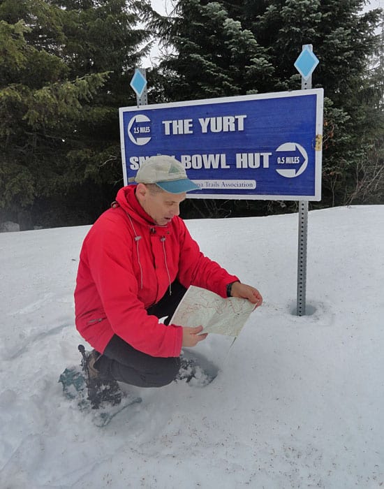
Situated in the center of the Mount Tahoma Trails Association’s South District network of trails, the Snow Bowl Hut makes an excellent base for exploring the surrounding ridges and valleys. A brand new, bigger, and better Snow Bowl Hut is now welcoming visitors, recently built following a devastating fire in the winter of 2007.
The warming huts along the Mount Tahoma Trails are closed during Covid.
Four overnight facilities in the area are all maintained and run by the non-profit MTTA. Touted as North America’s largest no-fee (although there’s a reservation fee for staying overnight) hut-to-hut cross-country ski trail system, the MTTA network is open to skiers and snowshoers of all ages and abilities.
From the large Sno-Park, follow the Outer Loop Trail, a busy snowshoe and cross-country ski arterial connecting to miles of radiating trails. Wasting no time gaining elevation, you’ll easily earn your lunch on the first half of this trail having burned many calories. Thankfully, the trail is regularly groomed easing the climb considerably compared to having to break tracks in a deep heavy new fallen snow.
At .35 mile, come to the first of several trail junctions along the way. This one is with the Anderson Lake Trail, which veers off right for three miles to two small ponds tucked beneath the steep ridge housing the High Hut. Trails and junctions are well-marked, but don’t always go by the distances stated as they are often short. Steadily climb. Much of the way is lined with thick forest, but occasional gaps in the green cover, reveal teaser views of the serrated Sawtooth Ridge just to the east. Mount Rainier is eager to show its face too, but you’ll need to climb a little higher before reveling in it.
At 1.2 miles reach the Middle Sno-Park (el. 2,900 feet), used when snow levels are high. The way takes a little break from climbing-then quickly resumes its upward march. At 1.9 miles come to the Upper Sno-Park (el. 3,400 feet), used when the snow levels are very high. Pass some grooming equipment, a tumbling tributary of Catt Creek, and then switchback to a junction with the Lower Yurt Trail. Continue straight and after another prolonged uphill slog reach a low saddle on a high ridge (el. 3,800 feet) at 2.6 miles. Here too is an important junction. Right leads to the High Hut. Continue left on the still groomed Outer Loop Trail.
After a small rise, descend slightly reaching a junction with the Next of Kin Trail at 2.8 miles. This ungroomed and lightly traveled path drops over 1,000 feet to the Mineral Creek Valley to reconnect with the Outer Loop Trail. A grand loop of 8.0 miles can be made back to the where you stand. Best to do the loop when staying overnight at the Snow Bowl Hut, lest the trip becomes nearly 14 miles-a challenge even for strong snowshoers.
Continue straight and once again climb-steeply for a short section. Following just beneath the ridgeline, trees obstruct much of the viewing out toward the Snow Bowl. At 3.6 miles the climbing ceases. And here just beneath a knoll at 4,350 feet you can catch a glimpse of the Snow Bowl, your desired destination. Now meander through tall timber and enjoy a short downhill jaunt to a junction (el. 4,250 feet) at 3.9 miles.
The Outer Loop Trail continues left dropping to a saddle to meet up with the Lower Yurt and Griffin Mountain Trails. Your route heads right along a semi-open ridge where winds occasionally create deep snow banks. Follow the groomed track or plunge along in the deep snow paralleling the way. After a short and easy climb, reach the Snow Bowl Hut (el. 4,360 feet) at 4.3 miles. If you’ve got reservations, you can hang up the snowshoes and cozy in for a quiet evening in the great outdoors.
Looking to go a little further? The Snow Bowl, a short .1 mile away, has been a favorite spot for area backcountry skiers for years. Snow collects deep and steep on the north facing slopes of this small bowl. An old clear-cut, when sufficiently covered with a white winter blanket it transforms into a nice little area for carving turns. Snowshoers may want to hike out to the bowl on a sunny day, sit back and watch the skiers do their stuff, all while big beautiful Mount Rainier hovers in the distance. Of course, there is plenty of terrain for a little snowshoeing too if you’re inclined to check out the lower reaches of the bowl. Just remember to save some energy for the trudge back up to the ridge.
Permits: Sno-Park Pass required; Reservations required for overnight stays in hut.
Contact: Mount Tahoma Trails Association;
Map: Mount Tahoma Ski Trail System (MTTA), available in Ashford at Whittaker Mountaineering
| Waypoints:
Trailhead: N 46° 42.360′, W 121° 59.571′ |