| Area: Mt. Tahoma Trails | Starting Point: Sno-Park for MTTA | |
| Distance: 6.8 miles, RT | Duration: 5-6 hrs | Difficulty Level: Moderate |
| Elevation Start: 2,125 ft | Elevation End: 4,125 ft | Elevation Gain: 2,000 ft |
-
- andersonLake 1

-
- andersonLake 5

-
- andersonLake 3

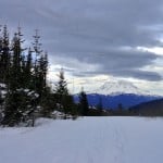
A small-two small lakes actually tucked below the steep north slopes of the ridge propping up High Hut; Anderson Lake is often overlooked by skiers and snowshoers intent instead on heading to the high country. But the lake set in a bowl just below 4,000-feet isn’t exactly in the flatlands, and the trail winding to it provides plenty of great views including of majestic Mount Rainier.
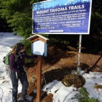
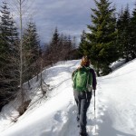
Part of the non-profit Mount Tahoma Trail Association’s (MTTA) extensive network of backcountry ski and snowshoe trails, the Anderson Lake Trail unlike the trails leading to High Hut and the Snow Bowl Hut is not groomed. And depending on how you like your winter recreation, that’s either a good thing or not. Snowshoers who like to break tracks after a new fallen snow will delight in this trail just fine. Others who don’t like to work so hard may want to opt to stay on the groomed much easier to travel trails.
Start on the Outer Loop Trail, the popular arterial leading to so many destinations within the south division of the MTTA network. After a mere third of a mile and a couple hundred feet of climbing you’ll come to the start of the Anderson Lake Trail diverting right. Take it and continue climbing entering the Bear Basin. Back in the summer of 1979, this entire basin went up in flames. Thirty-plus years later and blanketed in snow, you’d never know that a major wildfire had passed this way. It is pretty obvious though that the area is managed for timber production though as evidenced by the various aged stands of forest you’ll be traversing across.
The trail steadily climbs, making a few wide turns to ease the grade. High Hut sitting on the edge of a long steep ridge soon comes into view and stays in view for much of the way. More than likely a few folk from up above will catch notice of you trudging across the frozen landscape. Give them a friendly wave.
At 2.9 miles after a long and perhaps at times seemingly endless climb, reach a 4,125-foot gap. Take a break. Reach for your thermos and pour yourself a cup of hot tea. Then do an about face to revel in the glory of Mount Rainier filling the western horizon. What a sight! Now carry on enjoying a much easier final push to the lake. But first, heed a warning. The main trail continues left traveling across the base of steep slopes. Prone to avalanches it should be avoided. A bypass trail clearly marked veers right well away from the avalanche zone dropping a couple hundred feet to skirt the northern shoreline of a small lake.
Pick up the main trail once again and descend some more coming to a backcountry privy that’s probably best avoided-before finally reaching Anderson Lake (el. 3,850-feet) at 3.4 miles. When the lake is blanked in deep snow during prolonged periods of sub-freezing weather, you may be tempted to snowshoe across it. Otherwise it’s best to just admire the lake from its northern shoreline. The southern shoreline is prone to avalanches, so don’t venture over that way.
If you’re up for more exploring, cross Lake Creek and continue on the trail skirting the north shore of the lake. Strong and experienced snowshoers can make an adventurous loop. Beyond the lake, the route can be a little tricky climbing steeply out of the basin. Look for trail markers to help lead you .3 mile through thick forest to a small gap (el. 4,125 feet) west of the lake. Once at the gap, turn around and admire the lake-then enjoy a fairly smooth and straightforward .7 mile route to the High Hut Trail. En route the way traverses slopes of open forest providing excellent views south to the Snow Bowl Hut, Griffin Mountain and rows upon rows of peaks and ridges.
Depending on snow cover, a creek crossing may be a little tricky to negotiate. It has the potential of perhaps providing a little entertainment for your trail mates. At 4.4 miles from the trailhead reach the well-groomed and well-traveled High Hut Trail. If you have lots of energy, it’s just over a mile and 650 feet of climbing left to High Hut. Otherwise head right 3.2 miles back to the trailhead where you began from.
Trailhead directions: From Elbe (Junction SR 7 and SR 706) head east 10 miles on SR 7 turning right onto Kernahan Road (2.5 miles east of Ashford). Continue 1.4 miles south on Kernahan (which eventually becomes Skate Creek Road FR 52) bearing right onto Osborn Road (signed for Paradise Estates) then immediately turning left onto FR 85. Continue for 1.5 miles turning right onto dirt DNR Road No. 1. Follow for 2.1 miles turning left at a junction after crossing Catt Creek. Then proceed for 3.1 miles to trailhead at Sno-Park.
Permits: Sno-Park Pass required; Reservations required for overnight stays in hut;
Contact: Mount Tahoma Trails Association;
Map: Mount Tahoma Ski Trail System (MTTA), available in Ashford at Whittaker Mountaineering
| Waypoints:
Trailhead: N 46° 42.360′, W 121° 59.571′ |