| Area: White River |
Hike Type: Mountain views |
Pass: Natl. Park Pass |
| Distance: 7 mi RT | Duration: 5 hrs | Difficulty Level: Moderate |
| Snow-Free: Mid-July – Oct | High Point: 5,250 | Elevation Gain: 1,500 |
-
- IMG 4794

-
- IMG 4800

-

- IMG 4792

-
- IMG 4824

Features: wildflowers, old-growth forest, backcountry camping, subalpine lakes, solitude
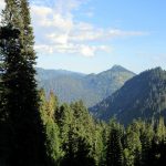
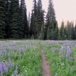
Hike through impressive stands of primeval forest to two subalpine lakes high above the White River Valley. The lakes are set in a meadow beneath the sawtooth multi-summited Governors Ridge—one of the most intriguing looking alpine landmarks within the park. In summer the lake basin blooms with wildflowers. In fall the grasses and sedges turn gold. While there are no views of Rainier—and no sweeping alpine views along this hike—it more than makes up for it in solitude.
Hit the Trail:
The parking lot is fairly small and often empty. That should be your first clue that this trail doesn’t receive a lot of foot traffic. Nearby at the Summerland Trailhead, cars are often wedged into every possible parking space available. Consider this hike as a nice alternative when Summerland’s carrying capacity has been reached. One of the nicest draws to this trail is the chance for real solitude. And by mid-autumn, solitude is almost assured.
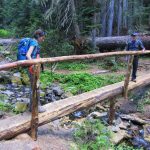
The trail enters a spectacular primeval forest and almost immediately begins to climb. The path is wide and the tread is smooth. The way makes some sweeping switchbacks via a moderate grade. In other words, the climb isn’t too bad. While hiking through ancient cathedral forests are pretty quiet once varied thrushes have piped down or moved on—that’s not the case here. You’ll constantly be reminded that you left the White River Valley behind. And when autumn rains have contributed their share to this glacier-fed river, it roars.
At the first switchback you catch a little glimpse of the rocky Shaw Creek drainage. Owyhigh Lakes are high above feeding this creek. Keep hiking upward winding beneath a luxuriant canopy. The way crosses a small creek twice and makes a couple of more wide switchbacks. Be sure to admire some of the monstrous yellow cedars along the way. At 3.0 miles near a log crossing over Tamanos Creek, reach a spur for the Tamanos Creek backcountry camp. This is a quiet spot to spend the night (permits required) especially if you just want to get away from it all.
In some years the small creek may run dry by late summer, forcing you to make a half-plus mile haul to the lakes for your water supply. Certainly this year with our abundant rainfall, lack of water is not an issue. Tamanos Creek starts from the slopes of 6790-foot Tamanos Mountain. Experienced scramblers shouldn’t have any problem negotiating this steep but non-technical peak. The mountain derives its name from the Chinook Jargon meaning a guardian or familiar spirit. It can also mean magic, luck, fortune, or supernatural. Spend enough time hiking around Mount Rainier and you’re sure to sense the presence of a Tamanos or two.
Now with almost all of your elevation gained, continue hiking enjoying some pretty easy going. Within a half mile break out of forest and enter meadows. The two Owyhigh Lakes soon appear to the left about 100 feet below the trail. In summer a healthy population of mosquitoes will make sure that you have little interest in a closer inspection. The lakes are pretty shallow and don’t invite swimming anyway. In autumn, however you’ll be able to plop down on a silver-sheened log and enjoy the tranquility of this subalpine environment.
Sit for a while and look around. Bears, dear, and mountain goats are all common inhabitants of the lake basin. Look up the rocky slopes and open avalanche chutes of Governors Ridge for any goat activity. Governors Ridge with its jawbone like ridge of jagged peaks will have no doubt by now intrigued you. A challenging scramble up loose rock and nasty gullies, this peak is best to just enjoy looking at from the lakes.
The peak received its name from a past park superintendent, Ethan Allen. He believed the peak should be named for all of the men who have held the office of governor or may hold it in the future. Since Allen’s tenure, quite a few women have held the governorship and a few men who have held the office who probably shouldn’t be commemorated. You’re probably wondering how the lakes received their interesting name. The lakes were named for Chief Owyhigh (or Owhi) of the Yakama tribe. Owyhigh had a summer camp in this basin and was believed to have loaned horses to Theodore Winthrop, a traveler from back east who wrote and popularized the Northwest in the 1850s. Winthrop Glacier on Mount Rainier is named for him.
If you’re a little curious as to what lies just up ahead on the trail, or you still want to burn some calories, keep hiking coming to a broad 5400-foot gap between Tamanos Mountain and Barrier Peak. Still no view of Mount Rainier (you need to scramble one of the surrounding peaks for that), but you do get a nice view of the Cowlitz Chimneys now.
The trail continues through meadows and quiet basins with window views east to Shriners Peak. It then descends following the cascading Kotsuck Creek to Chinook Creek. At 4.7 miles from the Owyhigh Lakes, the trail intersects with the East Side Trail. From here it’s .4 mile to the trailhead on SR 123. If you can arrange for transportation, the one-way trip makes for a great adventure—and the eastern section of this trails is even quieter than the western section. An out-and-back trip from the east is a good objective too, and aside for a longer hike, there is more elevation to be gained too. No matter your plans, savor the solitude and serenity of this special corner of the park.
Notes: Dogs-prohibited; permits required for camping (available at the White River and Longmire Wilderness Information Centers).
Contact: Mount Rainier National Park; https://www.nps.gov/mora/index.htm; (360) 569-2211
Maps: Green Trails Mount Rainier National Park 269S
Trailhead directions: From Enumclaw follow SR 410 east for 37.5 miles to Mount Rainier National Park turning right onto the White River Road. Continue for 3.5 miles to trailhead on your left—parking on your right.
Trailhead facilities: none
– Craig Romano, is an author of more than a dozen hiking guidebooks including the newly released 100 Classic Hikes Washington (Mountaineers Books) which includes several hikes in and around Mount Rainier National Park.
Waypoints
| Starting Point: N46 53.437 W121 35.820 | |
| Notable Waypoints:
Tamanos Creek Camps: N46 52.560 W121 35.208 Owyhigh Lakes: N46 52.038 W121 35.157 |
|