| Area: Sunrise | Hike Type: Overnight | Pass: Natl. Park Pass and overnight camping permit |
| Distance: 36.3 mi RT | Duration: 4 days | Difficulty Level: Strenuous |
| Elevation Start: 2,250 | Elevation End: 6,750 | Elevation Gain: 9,000 |
| Snow-Free: Mid-July – Mid-Oct |
-
- northern loop 5
-
- northern loop 4

-
- northern loop 2

-
- northern loop 1

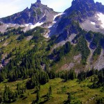
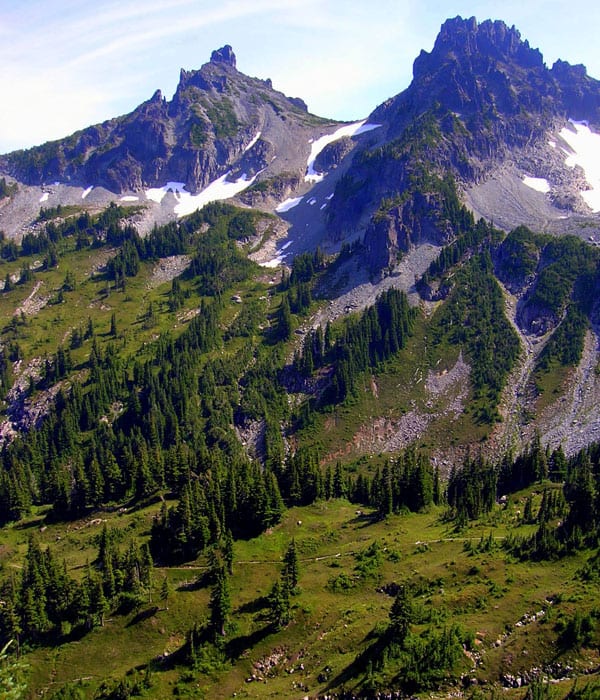
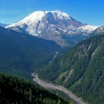
Consider the Northern Loop, a Wonderland Trail Lite. You still get a full adventure packed with spectacularly rugged scenery on this hike but with about one third the mileage of the epic trip around the Mountain. Plus, you’ll get about half the crowds too as you wander through the northern hinterlands of the park. Incorporating a stretch of the Wonderland Trail; the Northern Loop ventures across parkland meadows, alpine tundra, old-growth forest groves, glacial moraine, high passes, and low valleys.
Starting from Sunrise, you have three choices to access the loop which begins just beyond a five-way trail junction at Frozen Lake. Take the Sunrise Nature Trail to the highly scenic Sourdough Ridge Trail 1.5 miles to the junction, or follow the old Sunrise Camp Road for 1.5 miles. The meandering Sunrise Rim Trail will get you to the junction in 2.3 miles passing Shadow Lake en route.
From Frozen Lake perched in a barren windswept gap, continue west on the Wonderland Trail across alpine tundra within the shadows of “the mountain.” In .8 mile reach the Northern Loop Trail junction. Left or right, it’s your choice. Steep climbs and plenty of elevation gain and loss await you either direction.
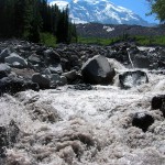
If you choose to do the Wonderland Trail part of the loop first, veer left steadily climbing to a 6,700-foot pass beneath Skyscraper Mountain. Views from the pass are sweeping, but they’re even better from Skyscraper’s 7,078-foot summit reached via a scramble path. Make the side trip or keep going, entering the forest and losing elevation. At about 5.0 miles from Sunrise, reach Granite Creek Camp. The camp is well sheltered from the elements and located close to the cascading creek. The trail continues descending, passing tumbling Garda Falls before emerging onto lateral moraine beneath the massive Winthrop Glacier. Here Winthrop Creek streams from the glacier’s snout. On hot days it thunders from it!
Cross the milky, silty, creek (el. 4,600 feet) on a foot log. Then, prepare for a long ascent to Mystic Lake. At 9.5 miles from Sunrise, reach the lovely lake (el. 5,700 feet). Campsites are located nearby in thick forest. Whether spending the evening or moving on, consider a dip in Mystic’s sparkling waters. The Wonderland Trail continues west along the grassy lakeshore and across flowering bogs before steeply climbing to a 6,060-foot gap. Views are splendid here of Rainier above and Moraine Park and the Carbon Glacier below. Through Moraine Park with its residual gregarious marmot population, descend once again. Now paralleling the Carbon Glacier, largest of the radiating icy fingers emanating down from “the mountain,” the sound of crashing water fills the air.
At 14.1 miles from Sunrise come to Dick Creek Camp located just above cascading Dick Creek. The trail descends for another mile reaching a junction with the Northern Loop Trail just below the snout of the Carbon Glacier. Your journey continues straight-but feel free to venture left along the suspension bridge for a thrill. The Carbon River Camp just across the river is a good choice for calling it a day.
Now leaving the Wonderland Trail, the Northern Loop heads downstream through a magnificent old-growth forest. At 1.2 miles from the last junction, come to another junction and the lowest elevation (el. 2,950 feet) on the circuit. The trail left heads back to the Wonderland Trail crossing over the Carbon River. You want to continue right arduously climbing up a steep hillside shrouded in ancient giants. After gaining 1,800 feet in just over 2.0 miles on a procession of switchbacks that feels like they’ll never end, the way eases. Now traverse flowering meadows beneath the stark wall of the Yellowstone Cliffs.
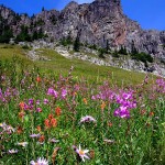
At 19.7 miles from Sunrise come to a .2 mile spur leading to Yellowstone Cliffs Camp (el. 5,100 feet). Nestled along a cascading creek at the edge of alpine meadows, it is one of the most scenic and inspiring backcountry camps in the park. From here the Northern Loop climbs for another 1.4 jaw-dropping miles to strikingly beautiful and wild 5-800 foot Windy Gap. Sparkling tarns invite you to drop your pack and linger. A .9 mile side trail invites further exploration. Follow it to a viewpoint of Lakes James and Ethel and an intriguing natural arch.
From Windy Gap, follow the Northern Loop alongside a gurgling creek descending through parkland meadows beneath a flank of jagged peaks. After passing a side trail to a backcountry ranger cabin, come to forest-ringed Lake James. Camps are located .1 mile farther (23.5 miles from Sunrise) on a forested bluff. The setting is tranquil in autumn but is abuzz with clouds of ravenous mosquitoes throughout most of the summer.
From here the trail continues through primeval forest gently descending for two miles to the West Fork of the White River (el. 3,250 feet). Cross its numerous channels and begin yet another arduously long and steep climb. After nearly 3.0 miles of uphill grunting, come to the junction (28.6 miles from Sunrise) for the spur trail to Fire Creek Camp. A half mile away, it’s a peaceful wooded camp. However, its water source may run dry by late summer.
The Northern Loop continues to climb passing a series of stunning viewpoints of Mount Rainier before coming to the Lake Eleanor Trail Junction at the edge of Grand Park; a near-level nearly two-mile long expanse of meadows. Continue right now heading south and cresting a 5,750-foot knoll. Then drop 400 feet to Lodi Creek and follow it upward through marshy meadows to heavily-used Berkeley Camp (32.4 miles from Sunrise). The way then makes its final climb, traversing Berkeley Park’s boulder fields and tumbling water fed gardens to reach a familiar junction with the Wonderland Trail in 1.6 miles. Head left 2.3 miles back to Sunrise content with finishing an incredible journey through some of Mount Rainier National Park’s wildest and loneliest terrain.
Trailhead directions: From Enumclaw follow SR 410 east for 37.5 miles to Mount Rainier National Park turning right onto the White River Road. Continue for 15.4 miles to Sunrise.
Overnight permits required and can be acquired at the White River Wilderness Information Center, (360) 569-2211 ext 6030, www.nps.gov/mora.
Special rules: No Fires-use camp stove. Dogs prohibited.
Special concerns: Cumulative elevation gain and loss makes loop an arduous and challenging circuit. Mosquitoes can be fearsome at Lake James.
Waypoints
| Starting Point: 46.9141, -121.64190000000002 | |
| Notable Waypoints:
Trailhead at Sunrise: N 46° 54.849′, W 121° 38.514′ |
|