| Area: Chinook Pass |
Hike Type: Family-friendly | Pass: No Pass Required |
| Distance: 4.2 mi RT | Duration: 2 hrs | Difficulty Level: Easy |
| Elevation Start: 1,331 | Elevation End: 1,349 | Elevation Gain: 0 |
| Snow-Free: Year-round |
-
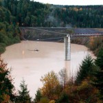
- dam full

-
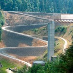
- dam empty

Offering fresh air, a chance for solitude and a big dose of the great outdoors, the recreational area at Mud Mountain Dam is a great place to spend time out in nature. An area with an interesting history as well, it’s run by the Army Corps of Engineers who regulate the flow of the White River. The dam was initially built to control serious flooding issues in the Auburn/ Puyallup Valley. This earth-filled dam was completed in 1948 and at the time, was the largest of its kind in the world. And lucky for us another result of the dam’s construction is a wonderful park at this site with covered picnic tables, a playground, a “kiddie” pool, and all sorts of open space. And when you’re ready to stretch your legs after a big picnic there are two wonderful trails to hike.
The first trail is found inside the park gate and begins at the Vista Sites.
Here you can view the dam and river below. Take a moment to read the interpretive information on the history of its construction. The short “Vista” trail (.3 mi.) is located on the other side of the platform and takes you down the hill to another observation deck closer to the dam. Here you can see how truly massive this earthen structure really is. The trail can be a little steep in places and occasionally closed for various reasons… one being the high water level in the rainy season.
The second trail is called the “Rim Trail”
This begins just outside the park gate. It follows the chain-link fence to the edge of the “rim” and continues for two miles. The trail crosses old access roads in a couple of places, but is marked with tabs, sometimes hard to see. This moderate trail travels through a delightful, sometimes dense forest with lush undergrowth. Along the way, you will run into a few, somewhat unexpected things in unlikely places, like an outhouse, a picnic table, boardwalks through the large swamp, and a nice little bench. Unfortunately you never get a clear view of the river and valley below. This trail is open to hikers and mountain bikes only.
A WARNING
The rim itself has some deep undercuts from high water and is very unstable. As tempting as it is to try to see the river, the rim edge is very dangerous and the 400 foot drop is unforgiving. The railings in many places are there for a reason and caution must be taken when the trail goes near the edge where there are no railings. You are safe as long as you remain on the trail. Children and dogs must be watched carefully.
At the end of the two miles is a gravel road you can take down to the valley floor. From here, hike another three miles along the river. Eventually the trail comes to a stream with no bridge. During the dry months the stream is smaller and crossable. Horseback riders use this road/trail often. There’s a large parking area for horse trailers at the top of this road. It is not open to off-road vehicles.
There are no fees for the use of this beautiful area.
To get here, follow Hwy 410 for four miles from Enumclaw’s last stoplight. You can’t miss the large sign directing you to the right. Follow this road for one mile to the horse trailer parking lot and another 1.5 miles to the park entrance. During the winter months, the park is closed on weekends, but access to the Rim Trail is year-round. There are a couple of unmarked accesses to the trail, but it really is most enjoyable if you hike the entire two-mile stretch. It’s a great place to get fresh air and exercise when you haven’t got a lot of time.
– Mary Janosik, Visit Rainier Hiking Expert
Waypoints
| Starting Point: 47.14520052569935, -121.93405951038208 | Website |
| Notable Waypoints:
|
|