| Area: Ashford |
Hike Type: Dog-friendly | Pass: none |
| Distance: 3 miles or 5 miles round trip | Duration: 2 or 4 hrs | Difficulty Level: Moderate |
| Elevation Start: 4,178 | Elevation End: 5,478 | Elevation Gain: 1050 ft/ or 1150 ft |
| Snow-Free: July – Oct |
-
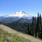
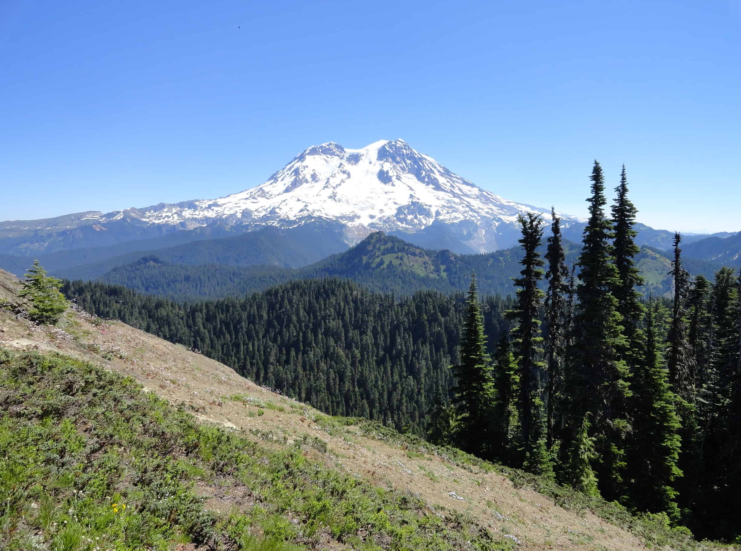
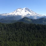
- Mount Rainier and the Gobbler Knob ridge from Mount Beljica
-
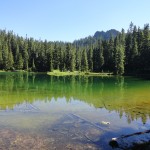
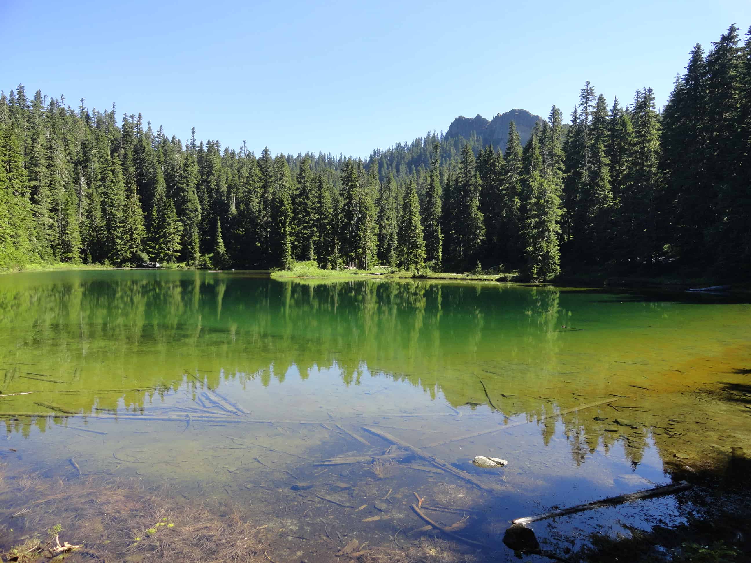
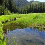
- Lake Christine
-
- Mount Beljica rising over Beljica Meadows 2

-
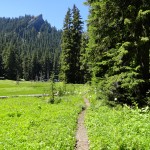
- Mount Beljica rising over Beljica Meadows

-
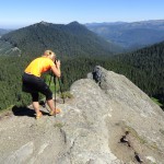
- A photographer taking advantage of Mount Beljicas beautiful location

-
- View west from Mount Beljica e1541793063300

A rocky 5475-foot pinnacle just west of Mount Rainier, Mount Beljica offers sweeping views of Washington’s highest peak. From this small but pronounced peak you can enjoy some one of the best views of Rainier’s heavily glaciated western face.
Located outside of the national park within the small but ecologically diverse Glacier View Wilderness, Beljica provides good views too, of Mount Wow, Gobblers Knob, Pyramid Peak, and other mountains flanking Rainier’s western front. There are two approaches to this peak, both short and both dog-friendly being outside of the national park. The approach from the south passes by lovely Lake Christine. The northern approach meanders through wildflower-saturated Beljica Meadows. Both routes traverse magnificent primeval forest.
The road leading to the southern trailhead is extremely rough and should only be attempted with a high clearance vehicle. The northern approach however can be accessed by passenger cars. If you can arrange for a pickup, consider doing a one way incorporating both approaches.
From the southern trailhead: The way starts off steeply skirting beneath some ledges before traversing a ridge. At 0.6 mile enter the Glacier View Wilderness. At just over 3,000 acres, Glacier View is one of the state’s smaller wilderness areas. Once threatened by logging, this small wedge of high elevation forest, meadows and lakes bordering Mount Rainier National became a wilderness area in 1984. With wilderness status, Glacier View’s prime wildlife habitat will remain unfragmented and the area will continue to be a wonderful hiking destination.
Just past the wilderness boundary, come to placid little Lake Christine. Once the mosquitoes are gone, this pretty little lake—oft lined with flowers is a wonderful place to spend the night. Find nice campsites by its outlet. The trail hugs the lake’s eastern shore and crosses the outlet stream on a small bridge.
Continue hiking north coming to a junction at 1.1 miles near a small saddle (elev. 5075 ft). Now head left climbing steeply but briefly reaching the rocky 5475-foot summit of Mount Beljica at 1.5 miles. Keep children and dogs nearby as it’s quite a drop off from the summit—and the views are sure to knock you off your feet, too!
Stare west over Gobblers Knob and Mount Wow to massive Mount Rainier. Admire a glistening face of ice and snow thanks to the massive Tahoma, South Tahoma, and Puyallup glaciers snaking down the peak. Look north too over the lush Beljica Meadows directly below and out along a jagged ridge which includes the old Glacier View lookout site. Then look east and notice the clear demarcation between wilderness and industrial forest. Look across the cutover hills to Puget Sound haze and the Olympic Mountains on the western horizon. Pull out your lunch and stay for awhile. The late afternoon sunlight dancing on Rainier’s glacial face is a photographer’s delight. And just in case you’re wondering about the origin of this mountain’s name. It’s an acronym made with the first letters of the names of the Mesler and LaWall families’ children; Burgon, Elizabeth, Lucy, Jessie, Isabel, Clara and Alex, who climbed this peak in 1897.
From the northern trailhead: Pass a small wetland and immediately enter the Glacier View Wilderness coming to a junction. Left heads to the old Glacier View lookout site and lakes West and Helen. You want to go right descending about 125 feet and coming to the edge of beautiful Beljica Meadows. A spur splits right to a handful of campsites. You want to continue left to cross a creek and emerge into the meadows. Now follow alongside the bubbling creek lined with showy wildflowers. Pointy Mount Beljica rises above the meadows making for an impressive backdrop.
The trail bends east to traverse more attractive meadows that burst with blossoms in mid-summer and are abuzz with mosquitoes until later summer. Look for elephant head orchids in the boggy meadows. Thousands of shooting stars streak the meadow shortly after snowmelt. Continue hiking entering old-growth forest and reaching a junction at 1.2 miles.
The way left crests a ridge before dropping a bit to Goat Lake. It’s a 1.4-mile side trip from the junction. From the lake, the trail continues another 0.9 miles entering Mount Rainier National Park (dogs prohibited) and climbing to reach the Gobblers Knob Trail not far from the lookout.
For Mount Beljica, head right. Climb through attractive old-growth forest and reach a junction at 2.0 miles just after cresting a 5075-foot saddle. Now turn right and climb 0.4 miles and 400 feet to Mount Beljica’s open summit. Enjoy the view of the meadows and forest you just hiked through—and of Mount Rainier nearby and hundreds of other peaks fading into the southern and western horizons.
Notes: Wilderness regulations apply. Free day permit required—sign in at the trailhead.
FR 59 is rough in spots but is passable for passenger cars. FR 5920 however, is extremely rough—high clearance and 4 x4 vehicle recommended.
Green Trails Map Mount Rainier West, WA no. 269 shows all Glacier View trails.
Contact Cowlitz Valley Ranger Station (Randle), Gifford Pinchot National Forest for updated information on this trail and access roads; (360) 497-1100; http://www.fs.usda.gov/giffordpinchot
Getting to Mount Beljica
Southern Trailhead: From Elbe, follow SR 706 east (passing through Ashford) for 11 miles. Turn left (north) onto graveled Copper Creek Road (FR 59) and follow for 4.3 miles. Then turn right onto FR 5920 and follow for 1.5 rough miles to the trailhead.
Northern Trailhead: From Elbe, follow SR 706 east (passing through Ashford) for 11 miles. Turn left (north) onto graveled Copper Creek Road (FR 59) and follow for 8.6 miles to road’s end and trailhead.
– Craig Romano, author, and co-author of 12 hiking guidebooks
Waypoints
| Starting Point: 46.78022595152315, -121.9444227218628 |