| Area: Longmire |
Hike Type: Off the Beaten Track | Pass: Natl. Park Pass |
| Distance: 10.1 mi RT | Duration: 5-7 hrs | Difficulty Level: Strenuous |
| Elevation Start: 2,150 | Elevation End: 5,900 | Elevation Gain: 3,750 |
| Snow-Free: July – Mid-Oct |
-
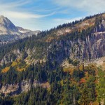
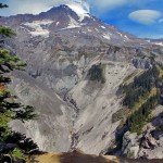
- c pyramid Peak seen from the Mildred Point trail

-
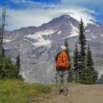
- a view from Mildred Point

-
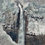
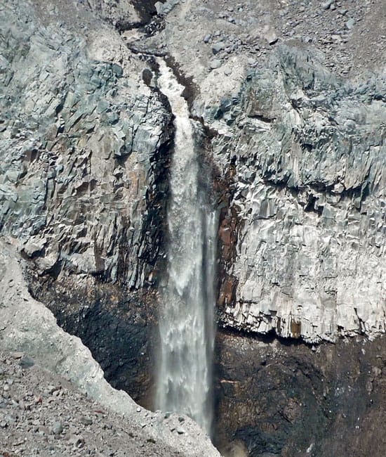
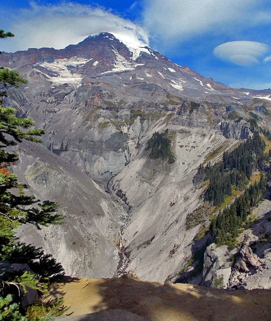
- y kautz creek waterfall
-
- x good place to stop
-
- b trail to Mildred Point

-
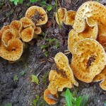
- mushrooms

Make room on your calendar for a hike to Mildred Point and enjoy this lesser-known, high-country dessert. It’s a lot of “up” but the trail rewards you with panoramic glacier views interspersed with waterfalls as well as quiet forested terrain.
We started at Longmire on The Wonderland Trail and in .6 miles crossed the Paradise Road (N 46° 45′ 13″, W 121° 48′ 48″) to begin ascending Rampart Ridge through a mostly old-growth forest. The trail is in good condition, even an ancient stretch of puncheon that crosses a boggy area below the junction with the Rampart Ridge Trail (N 46° 45′ 58″, W 121° 48′ 30″). We stayed on the Wonderland Trail as it continued climbing through the forest, seeing how many mushrooms we could find along the trail.
At the next junction we turned off onto the Van Trump Park Trail which also takes you to Mildred Point. The trail to Mildred Point climbs at a moderate grade through the forest, sprinkled with beargrass long past bloom.
As we hiked perky Canadian jays darted from tree to tree, their bright eyes sparkling as they perched on tree-branches in an obvious bid for hand-outs. There’s something about Canadian jays that always lifts our spirits, perhaps it’s their eternal optimism. We also heard the shrill of an unseen eagle which gave us goose-bumps though the day was warm.
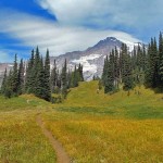
Eventually, the forest opens to the first of several meadows where the leaves of blueberry/huckleberry shrubs are turning orange and crimson. There were also many gentians still in bloom, their exquisite faces turned toward the sun. Groves of subalpine evergreens have quietly gathered as if to anchor the sprawling meadows in place.
At 4.5 miles we came to the last trail junction with Comet Falls. We turned left at this point as the trail cut across meadows toward Mildred Point, the gradient oblivious to the kindness of long switchbacks on tired knees (make no mistake, this is a steep trail).
From that last junction, the trail shows little sign of use; this trail is not hiked often these days since most hikers preferred starting at the Comet Falls trailhead. Despite the lack of hikers, the trail has been hiked enough that the trail is deeply embedded in the ground, in places a narrow ditch which tempts hikers to hike beside the trail (over time this creates a “new” trail); unfortunately it seems to be human nature that tempts one to take the softer, easier way rather than staying within the confines of the trail.
That first view of Mount Rainier when it breaks out of the forest never fails to incite awe. Though the weather was calm where we stood we could see the wind blowing strong on The Mountain as evidenced by whirling clouds at the summit. Lenticular clouds were also summit bound. Though the summit of Mount Rainier looked inhospitable, we wouldn’t have minded an icy breeze as it was warm in the meadows.
As we continued upward was it our imagination or had the trail grown even steeper than before? Here the concept of switchbacks was seemingly abandoned for good as the trail gets down to the business of getting to Mildred Point in a hurry. Here the steep trail crossed more meadows and as we gained elevation we could barely make out Mount Adams through the smoke from distant forest fires, rising above waves of dark-blue ridges, their outlines blurred by haze.
As we continued to climb the trail grew more vertical and necessitated taking what we call “giant steps,” especially where the trail had turned to dust. Clouds of dust rose with each step, our boots adding tracks to those made by elk, deer and mountain goats.
A few final giant steps lead to the brink of Mildred Point where a sign warns that this is the end of the maintained trail. That sign hardly seems necessary as going beyond the sign would entail the necessity of a parachute for landing on the glacier below. Here above the yawning chasm, our eyes were drawn to a series of waterfalls plunging from the Kautz glacier as Mount Rainier indifferently looked on, serenely positioned above the ever-changing tableau of crevassed glaciers, waterfalls and the rubble of moraines. Geologically speaking Kautz Creek Falls is “young” as it was formed by the retreat of the Kautz Glacier. We stayed well away from the edge; so should you.
There we spotted a game-trail that contoured a little below the edge of Mildred Point that veered through a few scrappy, subalpine trees; we could not resist following it a little way. Thus we were startled by the sudden sight of a mountain goat’s head peeking at us over the lip of the void. He was as surprised to see us as we were to see him and he dropped out of view before we could say “camera!”
The path leads to another high point where the view of the Kautz Creek waterfalls are obscured by trees but provides clear views to the east and the surrounding landscape where we spotted more mountain goats in the distance as they traversed an almost vertical meadow. They were too far away to photograph so we paused to watch them, envying their agility at negotiating the formidable terrain.
As we retraced our route through the meadows the skies had grown hazier – we could barely make out the silhouette of Mount Adams. The sun’s angle heightened the intense reds and oranges of blueberry shrubs as we negotiated the narrow entrenched trail through meadows, doing our best to avoid the human-made trail beside it.
Soon we were back in the forest, grateful for the occasional cool breeze that came our way, not even begrudging an uphill stretch we’d been dreading on the way down to Longmire.
For additional information on fees, rules and regulations, current conditions, and weather call Mount Rainier National Park (360-569-2211) or visit their website at www.nps.gov/mora/. The recommended map for Mount Rainier National Park is Green Trails (Mount Rainier Wonderland Map 269S).
– Karen Sykes, Visit Rainier Hiking Expert
Waypoints
| Starting Point: 46.74946,-121.81193000000002 | |
| Notable Waypoints:
Longmire Starting Point: N 46° 44′ 58, W 121° 48′ 43 |
|