| Area: Longmire | Starting Point: Longmire | |
| Distance: 3.9 miles, RT | Duration: 2-3 hrs | Difficulty Level: Easy |
| Elevation Start: 2,024 ft | Elevation End: 3,180 ft | Elevation Gain: 400 ft |
-

- heading up toward Cougar Rock
-
- along the Wonderland Trail
-
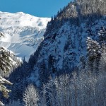
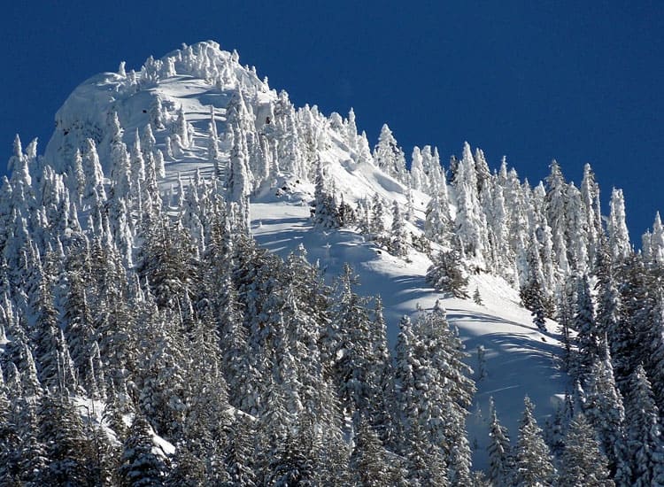
- fresh snow on Eagle Peak
-
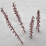
- coralroot in the snow

-
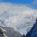
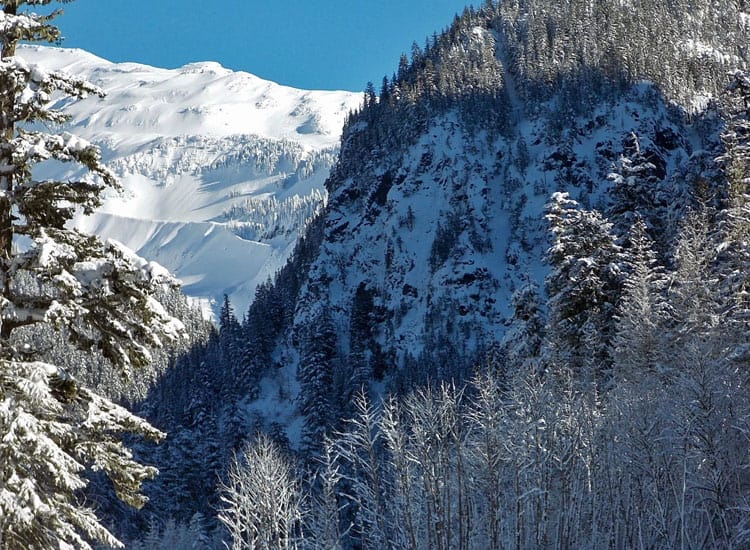
- glacier view

The Wonderland Trail is 93 miles in length but many visitors hike, backpack or snowshoe a piece of it at a time. Plus, if you’ve never snowshoed or hiked a stretch of The Wonderland Trail this is a good place to start.
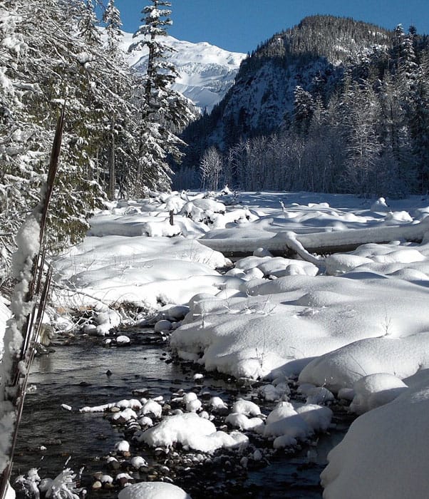
The trail from Longmire to Cougar Rock is a quiet stretch with the Nisqually River often within sight. Even where the trail is forested it is restful with the sigh of the river and in winter, wisps of lichen hang from alders, like shawls beaded with jewels. Jacobs Ladders fall through the evergreens and spindrift falling from the trees glitters like diamond chips.
Most snowshoers use trekking poles or ski poles for balance. Though this snowshoe is considered a beginner’s special you will still need sturdy boots, extra clothing, rain-gear, water and snacks.
On a busy weekend you might find the trail packed hard enough you don’t need snowshoes though you will be at the risk of post-holing (breaking through the snow). Hikers who venture onto snowy trails without snowshoes may find themselves post-holing often enough that they turn back in frustration (ask us how we know this).
This segment of The Wonderland Trail starts at Longmire and parallels the Nisqually River. Find the designated trail on the (northeast) side of the National Park Inn near the Wilderness Information Center. Per the sign, continue straight toward Cougar Rock and/or the Cougar Rock Campground.
On a crisp, sunny day you are unlikely to have the trail to yourself and on our recent visit the weather was ideal for snowshoeing with sparkling snow and blue skies. We met snowshoers of all shapes, ages and sizes on the trail both coming and going.
The branches of evergreens were flocked with snow and glittering mounds of snow piled where Jacobs Ladders fell. As we snowshoed through the dappled light we stopped for photos of coral-root poking out of the snow, still holding its distinctive shape.
Along the way look for places where snowshoers have blazed short spurs to overlooks of the Nisqually River and the snowy splendor of Eagle Peak rising above. If you venture out onto these human-made overlooks don’t step too close to the edge; the banks of the river are undercut in places and it can be hard to tell where terra firma ends especially when there is snow on the ground. The views of the Nisqually River are wondrous; on our visit the Prussian blue river was running low, snow-topped boulders flanked the river, and white alders stood out in bright contrast to somber evergreens on the far side of the river; in a word; breathtaking.
You’ll soon come to a signed junction for the lower loop of the Cougar Rock Campground (keep in mind it could get buried in snow). We opted to save that exploration on our way back to Longmire. From that junction it’s only a short distance to an open spot where The Wonderland Trail crosses the Nisqually River on a footbridge. From the open area you can drop down to the river for views of Mount Rainier; this is a fine place to turn around or take a break.
Where the trail crosses the Nisqually River there is an impressive view of Mount Rainier – even if you are denied a view of Mount Rainier this is still a fine spot to linger. Witness the chaotic topography of up-ended trees, boulders and debris that illustrate the mountains oft-violent, geological past. The river has in recent history jumped its banks during periods of historic rainfall; in summer the river is content to stay within its banks though even then you’ll hear boulders tumbling in the river as they break loose from higher regions of instability. In winter water-levels are low though Mount Rainier is never genuinely still; Mount Rainier is a slumbering beast likely to stir again. It is a mountain to admire but to also take seriously.
We dropped down to the bridge where you’d need to cross the river if you wanted to continue on to Carter Falls or further. We saw where others had used the bridge to cross; however the snow overhung the edges of the bridge so if you cross do so with caution (snowshoers were probing the snow on the bridge with trekking poles to see where the snow broke through). A tumble into the icy river could lead to hypothermia at the very least.
We made the bridge our turnaround and backtracked to the Cougar Rock Campground junction to explore the lower loop of the Cougar Rock Campground. As soon as we crossed the highway we immediately plunged into deep, fluffy snow. Here the snowshoes became a necessity; not a choice. My partner, broke through the snow immediately so we did not venture far. If you explore the campground you will also need to cross the Nisqually-Paradise road with caution (watch for cars that might not be able to brake quickly if the road is icy).
In what seemed like no time at all we were back at Longmire but not ready to call it quits. Back at Longmire we crossed the Nisqually-Paradise Road to the Trail of the Shadows (also described on this website) where park rangers were checking vehicles for chains – chaining up was required beyond Longmire (Remember, you are required to carry chains inside the park during winter even if you don’t use them.).
For additional information on fees, rules and regulations, current conditions, weather, reserving campsites call Mount Rainier National Park (360-569-2211) or visit their website at www.nps.gov/mora/ . The recommended map for Mount Rainier National Park is Green Trails (Mount Rainier Wonderland Map 269S).
– Karen Sykes, Visit Rainier Hiking Expert
| Waypoints:
Trailhead: N 46° 44′ 57, W 121° 48′ 41 |