| Area: Kautz Creek |
Hike Type: Mountain views | Pass: Natl. Park Pass |
| Distance: 11 mi RT | Duration: 7 hrs | Difficulty Level: Strenuous |
| Elevation Start: 2,477 | Elevation End: 5,335 | Elevation Gain: 3,800 |
| Snow-Free: Mid-July – Mid-Oct |
-

- flower fields before Pyramid Peak near the Mirror Lakes

-
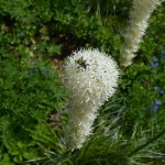
- Beetle on bear grass at Indian Henrys Hunting Ground

-
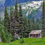
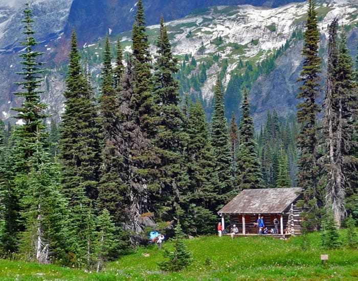
- view of the cabin
-
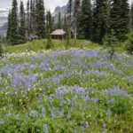
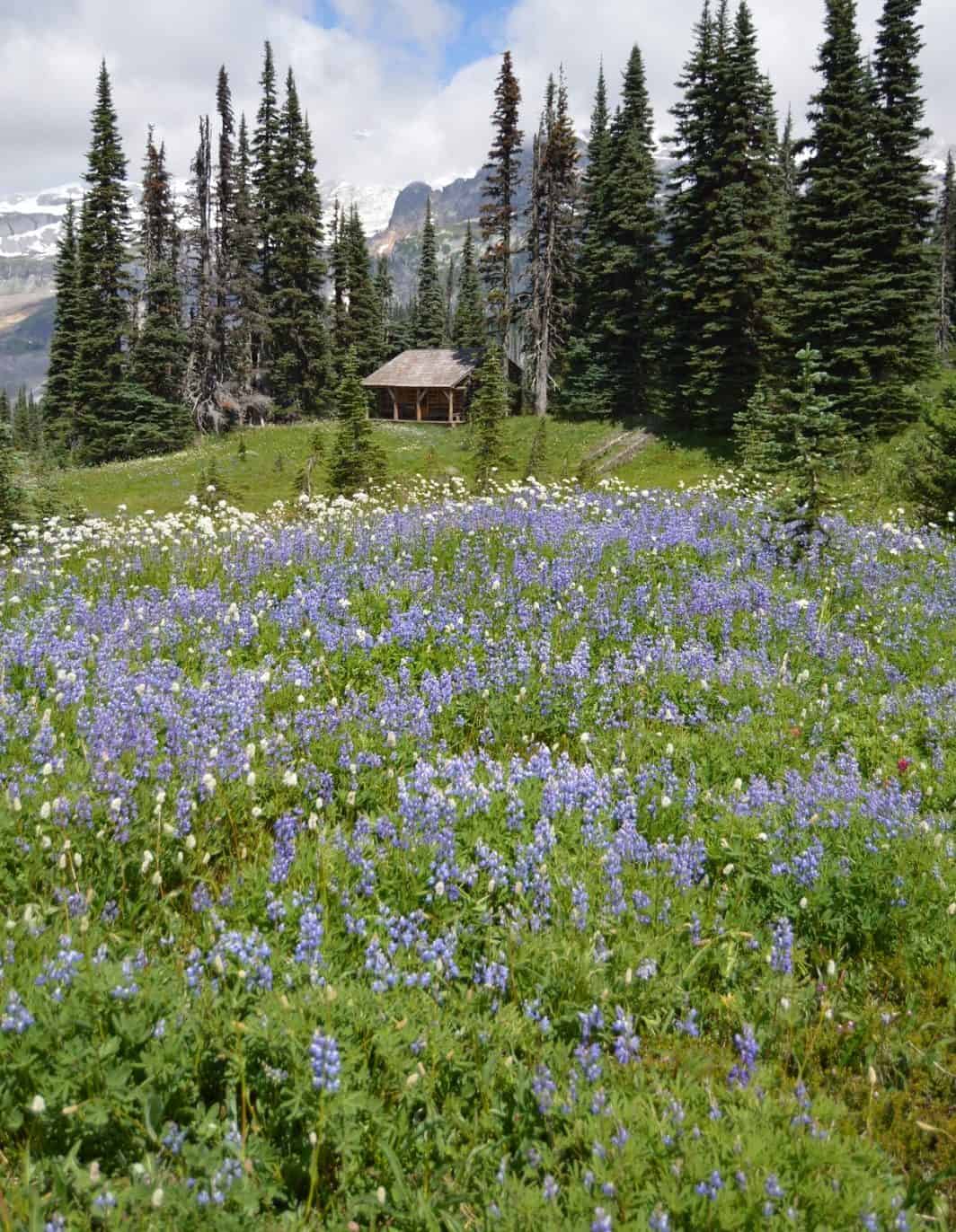
- Fields of lupine at Indian Henrys Hunting Ground e1541621711823
-
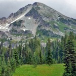
- pyramid peak

-
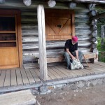
- cabin porch

There isn’t an easy way to get to Indian Henrys Hunting Ground, although to hike to this special area of Mt. Rainier National Park is worth the effort. A hiker has several approaches from which to choose: the Tahoma Creek Trail (via the West Side Road), the Wonderland Trail access at Longmire, the Rampart Ridge Trail (trailhead is just south of Longmire) or the Kautz Creek Trail.
Each approach has its pros and cons. The Wonderland Trail approach from Longmire is long. Experienced hikers can approach from the West Side Road via the abandoned Tahoma Creek Trail; that route cuts down on mileage, but the Tahoma Creek Trail is in such bad shape you could hardly call it a trail; maintenance – if any – is limited. The approach from Rampart Ridge is strenuous but offers great views off of its spur trails. The Kautz Creek Trail is direct but steep with limited views in areas though the trail makes up for that later. We will spend this article exploring the approach from Kautz Creek.
The first mile of the Kautz Creek Trail parallels a dry channel where the creek used to flow before storms and floods wrought havoc in 2006; that first mile of trail had to be rerouted. After crossing the channel, the trail enters the forest and heads steeply uphill with a few level stretches here and there. While relentlessly steep the trail is in good condition overall.
As forest gives way to meadows, we checked the status of blueberries and are happy to report that in late August, they are ripening. Small meadows between stands of evergreens allow for views of Mount Ararat looming above the trail (left), appearing more formidable than to those who have scrambled to the summit. At this time, steep meadows on the flanks of Ararat were still vivid with wildflower displays going strong. We saw hellebore (in seed mode), Indian paintbrush, valerian, lupine, bistort and a few tiger lilies still in bloom.
On a clear day there is a good view of Satulick Mountain (right) from a large meadow a little further along. Here we startled a small black bear that sat down on its haunches and looked at us as if to ask “What are you?” We gaped at each other long enough that we failed to get a photograph before the bear scampered off into the forest.
Just before the trail climbs to a rocky pass there is an arrangement of overhanging boulders (N 46° 47′ 17″, W 121° 50′ 48″; 5,574 feet) with enough space to keep a hiker dry on a rainy day. We’ve dubbed it “The Bivouac” having taken shelter there on a previous, rainy hike. From the boulders, the trail climbs a few more feet to a rocky pass before dropping down into meadows where we could see the patrol cabin in the distance. On this misty morning Indian Henry’s patrol cabin shimmered like a mirage; the last stint is a wonderful walk through a knee-deep grassy meadow filled with wildflowers.
Indian Henry was a Native American who preferred to live at the foot of Mount Rainier. In the early 1880s Henry (whose native name was So-to-Lick) guided James Longmire, P. B. Van Trump and George B. Bayley to a high point on Mount Rainier (near Camp Muir) with packhorses. P. B. Van Trump used Indian Henry’s Hunting Ground as a base of guiding operations before 1900.
Following the trail we continued to a signed junction where we joined the Wonderland Trail that comes in from Longmire – a few hundred yards beyond is another junction where a short spur leads to the patrol cabin. The Wonderland Trail continues toward Tahoma Creek, a spur to the right leads to Mirror Lake after 0.3 miles.
We’d hoped to find the cabin open but it was locked. It was chilly enough that the smell of that morning’s wood’s smoke from the cabin almost maddened us as we envisioned ourselves enjoying lunch inside a warm cabin; however, this was not to be! A register and a bear log was laid out on the porch so we signed the register and wrote in the log about the bear we saw. We were surprised to be alone at the cabin as this is one of the most popular destinations in the park but it wasn’t long before other hikers arrived. If you find the patrol cabin locked (and you probably will as the attending ranger is often out and about) there are benches on the covered porch where you can settle for lunch and/or wait for the weather to clear.
We recommend saving this hike for a long, summer day so you can take your time enjoying the views and identify peaks denied to hikers on a cloudy day. On a clear day there are views of Iron and Copper Mountains; a look at the map will reveal other possibilities for hikers including a side-trip to the airy suspension bridge over Tahoma Creek on the Wonderland Trail or a visit to nearby Mirror Lake.
Back at the Wonderland Trail junction we opted for Mirror Lake, continuing 0.3 mile on the Wonderland Trail (right) to the junction for Mirror Lake (N 46° 47′ 45″, W 121° 50′ 30″; 5,282 feet ). From that junction it is 0.5 miles to Mirror Lake. Of course, hikers can also opt to continue on the Wonderland Trail to the suspension bridge over Tahoma Creek or further. Though no longer maintained, the half-mile trail was in good condition except for a few boggy areas. The trail skirts a ghost forest that stood in stark contrast against a flower-filled meadow before it skirts the edge of Mirror Lake, the shoreline bordered with magenta paintbrush and valerian.
The trail to Mirror Lake also serves as a route to Pyramid Mountain, considered a “walk-up” for those with scrambling skills. We did not have time to climb Pyramid Mountain but did venture a little beyond Mirror Lake, checking out game trails and spurs that led to unexpected views of the Tahoma Glacier, the South Tahoma Glacier and Glacier Island. Just past Mirror Lake the park has placed a metal sign reminding hikers to travel with care beyond that point. This part of the park is less known and it was exhilarating to discover it.
Turnaround time always comes too soon for us. We retraced our route back to Indian Henrys – we saw several hikers sitting on the porch. The climb out of Indian Henrys Hunting Ground wasn’t as steep as we anticipated and soon we were hurtling through the forest with visions of hot coffee and a change of clothing at the car.
Getting to the trailhead: From the Nisqually Entrance of the park, drive about three miles to the Kautz Creek trailhead and parking area (right). The trail begins on the other side of the road.
For additional information on fees, rules and regulations, current conditions, weather, reserving campsites call Mount Rainier National Park (360-569-2211) or visit their website at www.nps.gov/mora. The recommended map for Mount Rainier National Park is Green Trails (Mount Rainier Wonderland Map 269S).
– Karen Sykes, Visit Rainier Hiking Expert
Waypoints
| Starting Point: 46.735782,-121.85605 | |
| Notable Waypoints:
Trailhead: N 46° 44′ 09, W 121° 51′ 22 |
|