| Area: Sunrise | Hike Type: Views | Pass: Natl. Park Pass |
| Distance: 10.1 mi, one-way | Duration: 5-6 hrs | Difficulty Level: Moderate |
| Elevation Start: 3,042 | Elevation End: 6,415 | Elevation Gain: (+) 400, (-) 3,834 |
| Snow-Free: Mid-July – Sept |
-
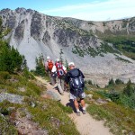
- On the upper trail

-
- P1080368

Looking for a hike that delivers views right out of the gate? That takes you from tundra-like terrain, past a beautiful lake, into old-growth forest and offers solitude? Then the Huckleberry Creek trail out of Sunrise should be on your radar.
Set up a car shuttle to do this hike as a one-way trip: leave one car at the lower trailhead off of FS Road No. 73 and then drive the second vehicle to the Sunrise parking lot where the hike begins. Both cars will need to be high clearance, 4WD as FS Rd. 73 is in bad condition.
From the parking lot follow the short spur to the Sourdough Ridge Trail – the spur is between the restrooms and the Sunrise Visitor Center. After a short stint on the Sourdough Trail, turn right at the Huckleberry Creek trail junction (N 46° 55.140′, W 121° 39.200′) and begin your descent into spectacular Huckleberry Basin on a series of switchbacks.
It’s fascinating to hike through a variety of terrain; after descending through the remnants of a moraine interspersed with ripening meadows, we stopped for lunch at the edge of a boulder field surrounded by tawny ridges, meadows and peaceful groves of sub-alpine trees. Another option for hikers is to stop for lunch at Forest Lake (5,742 feet), further down the trail. However, mountain lakes are notorious for biting bugs in summer hence our decision to stop for lunch where we did (by September, the mosquitoes that lurk at tarns, lakes and ponds are mostly gone).
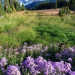
In the last days of August a few flowers were still blooming; monkey flowers, yarrow, pearly everlasting, asters and gentians just beginning to appear. By September there will be scads of these lantern-shaped blue flowers glowing like Tiffany lamps in the meadows.
After dropping about 1,100 feet or so we reached Forest Lake, situated where forest, meadows and high country overlap. There is a designated campsite at the lake and surprisingly, in late August, no bugs.
From the lake we continued our descent into deeper forest, crossing Huckleberry Creek several times on footbridges. The forest was a mix of yellow cedars, Douglas firs, Alaska cedars, vine-maple with an under-story of huckleberry/blueberry shrubs, Devils Club, Canadian dogwood and ferns (oak, deer, bracken and sword ferns).
Beyond Forest Lake it is a lonesome path; you may feel like Hansel and Gretel as you wind through this enchanted forest where few hikers tread. There are no dramatic views beyond Forest Lake but the trees are so magnificent that the trees become the view.
In addition to Huckleberry Creek you’ll cross Prospector Creek, Josephine Creek and Lost Creek (in that order); none of the crossings were difficult in August and should be fine through late-September into early October.
The trail is easy to follow with only one short stretch where feeling for the trail with your feet may be required; here the trail was covered with thimbleberries (sadly for us, no ripe berries).
Just inside the border of the park we came upon an old patrol cabin (N 46° 59.670′, W 121° 37.110′); locked and shuttered for good. An old trail register (not used in a very long time) was on the front porch, fading signs with rules and regulations within the park were still posted, including one that dated back to the 1940s. We also found a boundary sign and a benchmark dating back to 1900.
From the park boundary the trail continues on Mount Baker Snoqualmie National Forest land; it is about a mile hike out to Forest Road 73.
Notes: From Sunrise this is a steep, downhill hike, not recommended for hikers with bad knees. Forest Road No. 73 is not recommended for passenger cars; the road is rough. Some hikers may be happier hiking from Sunrise to Forest Lake, then climbing back to Sunrise (an elevation gain of about 1,100 feet).
The Visitor Center at Sunrise closes in mid-September; the trails at Sunrise will remain open to hikers until the road to Sunrise is closed by snow later in the fall. Call Mount Rainier National Park to make sure the road to Sunrise is open if you are starting your hike at Sunrise. If you have a 4WD rig you can also start at Forest Service road (No. 73) and hike uphill as long as time and stamina allow. For road conditions (Forest Service Road No. 73) call Snoqualmie National Forest in Enumclaw at 360-825-6585.
Getting to the Huckleberry Creek trailhead (Trail No. 1182) on Forest Road No. 73: Drive east on SR 410 from Enumclaw (about 24.8 miles) to Huckleberry Creek Road No. 73, turn right onto Road 73 and continue about 6.5 miles. The trailhead (unsigned) is on the left side of the road before the road crosses Huckleberry Creek (park on the road shoulder).
– Karen Sykes, Visit Rainier Hiking Expert
Waypoints
| Starting Point: 46.914444, -121.642222 | End Point: |
| Notable Waypoints:
Trailhead at Sunrise: N 46° 54.87′, W 121° 38.53′ |
|