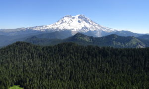
Discover the beauty of the Mount Rainier region through diverse hiking trails, ranging from easy strolls to the epic 93-mile Wonderland Trail. Use our trail directory to find your ideal hike based on distance, difficulty, and snow conditions. Enjoy, explore, and respect these public lands. Help preserve these unique places by practicing Leave No Trace principles and recreating responsibly.
Find trails in all corners of the park, for all ability levels. Use the sortable list below to find the perfect hike for you.
Trail Etiquette | The 10 Essentials | Permits & Passes | Choosing a Hike
| wdt_ID | Title | Difficulty | Distance | Duration | Elevation Gain | Snow-Free | Pass Required |
|---|---|---|---|---|---|---|---|
| 1 | Allen Mountain | Moderate | 10 mi RT | 6 hrs | 2.350 | July - October | None |
| 2 | Alta Vista Trail | Easy | 01.2 mi RT | 0.75 hr | 520 | Mid-July - Mid-September | Natl. Park Pass |
| 3 | American Ridge Via Goat Creek | Easy | 08.2 mi RT | 4-6 hrs | 2.600 | July - Early-November | None |
| 4 | Bearhead Mountain | Moderate | 05.8 mi RT | 3 hrs | 1.789 | July - Late-October | NW Forest Pass |
| 5 | Bench and Snow Lakes | Moderate | 02.6 mi RT | 1.5 hrs | 700 | July - October | Natl. Park Pass |
| 6 | Berkeley Park | Moderate | 11.3 mi RT | 6 hrs | 400 | Mid-July - Early-October | Natl. Park Pass |
| 7 | Big Crow Basin and Basin Lake | Strenuous | 15.8 mi Loop | 2 days | 4.000 | Late-June - October | Overnight Camping Permit |
| 8 | Boise Creek | Hancock Lands | Moderate | 03 mi RT | 2-3 hrs | 300 | April - October | Hancock Lands Permit |
| 9 | Boulder Cave Natural Area | Easy | 02.25 mi RT | 1-2 hrs | 300 | June - September | NW Forest Pass |
| 10 | Boundary Trail Carbon River | Moderate | 02.6 mi RT | 2-3 hrs | 1.320 | June - October | Natl. Park Pass |
| 11 | Boundary Trail Nisqually Entrance | Moderate | 05.6 mi RT | 4-5 hrs | 2.700 | July - September | Natl. Park Pass |
| 12 | Brown Peak via Palisades Lakes Trail | Moderate | 08.6 mi RT | 5-6 hrs | 1.800 | July - October | None |
| 13 | Bullion Basin Loop | Moderate | 08.1 mi RT | 2-3 hrs | 2.420 | June - October | None |
| 14 | Burroughs Mountains | Moderate | 05.4 mi RT | 3-4 hrs | 1.443 | Late-July - September | Natl. Park Pass |
| 15 | Camp Muir Trail | Strenuous | 09 mi RT | 8-10 hrs | 4.788 | Mid-July - Early-September | Natl. Park Pass |
| 16 | Carbon Glacier Trail | Strenuous | 17.5 mi RT | 6 hrs | 1.300 | Early-May - Late-November | Natl. Park Pass |
| 17 | Carbon River Road to Ipsut Falls | Easy | 10.8-15 mi RT | 3-7 hrs | 700 | Year Round | Natl. Park Pass |
| 18 | Carbon River Road Hike | Moderate | 16 mi RT | 9 hrs | 640 | Mid-March - October | Natl. Park Pass |
| 19 | Chenuis Falls | Easy | 06.4 mi RT | 4.5 hrs | 50 | April - October | Natl. Park Pass |
| 20 | Cispus Braille Trail | Easy | 01 mi Loop | 0.5-1 hr | 0 | May - October | None |
| 21 | Cora Lake | Easy | 01.4 mi RT | 1 hr | 400 | June - November | None |
| 22 | Corral Pass | Easy | 02.6 mi RT | 1 hr | 560 | July - October | NW Forest Pass |
| 23 | Cougar Lakes via the PCT | Strenuous | 19.2 mi RT | 2-3 days | 3.200 | Mid-July - Late-October | NW Forest Pass |
| 24 | Cowiche Mountain | Moderate | 06.2 mi Loop | 4-5 hrs | 1.250 | March-November | None |
| 25 | Cowlitz Divide | Strenuous | 11.8 mi RT | 6-7 hrs | 2.850 | July - October | Natl. Park Pass |
| Title | Difficulty | Distance | Duration | Elevation Gain | Snow-Free | Pass Required |
Use the checkboxes below or the letters at right to filter your results.
Search
Season
Category

Boulder Cave Trail #962 is a 1.5-mile round-trip trail open seasonally; timed reservations are required.

Hike to one of the four remaining fire lookouts in Mount Rainier National Park. Perched on an open 7,181-foot knoll on rocky Mount Fremont, this historic structure is the highest of the park’s lookouts.
Mount Beljica is a 3 to 5 mile hike in Ashford, Washington on dog-friendly trails that requires no entrance fee. Learn more at VisitRainier.com.
Van Trump Park / Comet Falls
The Packwood Lake trail is open to hikers and equestrians; mountain bikes, motorcycles, and ATVs are prohibited. Learn more at VisitRainier.com.