| Area: Enumclaw |
Hike Type: Family-friendly | Pass: Discover Pass |
| Distance: 2.5 mi Loop | Duration: 1 hr | Difficulty Level: Easy |
| Elevation Start: 341 | Elevation End: 385 | Elevation Gain: 300, gain+loss |
| Snow-Free: Year-round |
-
- Flaming Geyser 0618

This park in the wilderness, located on the scenic Green River, is not far from urban centers, yet is seemingly miles away. Visit nature’s oasis for a walk through the woods and escape the noise of every day hustle and bustle. Giant cedars and maples are plentiful, the forest floor is dense with numerous varieties of plants and velvety moss covers everything from the smallest stick to the largest tree. There is a swampy area where birds, turtles and beaver live. There are signs of elk everywhere, but they are hard to see. (I have no idea where they hide.) The beauty of this moderate rainforest and the ever-changing river will amaze you, regardless of the season.
Flaming Geyser State Park is named after a natural gas vent, that before it was capped, shot a flame eight feet into the air when lit. Now the cap controls the flame to about 6-8 inches… not as impressive to view, but interesting nonetheless. In the creek above the main public area, there is another natural bubbling Sulpher Geyser, accessed by a very nice trail, to be discussed below.
There is something for everyone here. Relax and enjoy the peace and quiet of nature or take part in various enjoyable activities. Fish in the river (during fishing season), hike or walk the many trails, ride horses in designated areas, or fly your remote control airplane with the many other flying enthusiasts. There are many picnic areas for groups of any size. Flaming Geyser is also a frequented take-out location for kayakers who have braved the rapids of the Green River Gorge upstream. Swimming and tubing in the park are popular summertime activities, but the river is not a place for those who are careless. It can be unforgiving and should be approached with extreme caution.
Of course, we like the hikes. As you cross the bridge after entering the park, you find yourself in open fields. There are walking paths on the perimeters of these fields with river access for fishing. Beyond the stop sign and around the end of the hill on the right is a trailhead taking you up on the hill above the valley floor. (Take a left at the stop sign for parking and walk to this trailhead.) This moderate 1+ mile trail has so much to offer in incredible sights and smells of the moderate rainforest. Eventually the trail drops off the hill into the main, large picnic area at the end of the road. This is the best work-out hike in the park, as well as being a VERY pretty trail.
All other trails originate from the main picnic area. At the end of the road, the park provides an educational trail composed of a material making this path wheelchair accessible. Along the way information posts provide interesting facts about the natural life cycle of the variety fish found in this river and how preserving the ecosystem helps them AND us. You can see hundreds of spawning salmon in the side stream in October and young steelhead in the rearing ponds (near the lodge) at different times during the year. I bet you will learn something you didn’t know when walking this very interesting path.
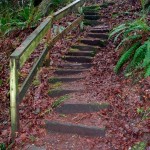
You may choose to hike a short, somewhat easy, loop trail beginning at the Flaming Geyser. This trail crosses a footbridge, then follows the creek up a gentle grade to the Bubbling Sulfur Geyser… you will smell it before you see it. Along this trail are big trees and large rocks and a few raised walkways that attempt to keep you out of the muddy spots. At one point along the trail there are remnants of a large landslide on the other side of the creek. Before this event, the trail continued up the creek and up the opposite side, connecting to the main “hill” trail. The landslide took out a huge section of the hill, forcing the closure of a long stretch of trail. Now the creek trail takes a left at the Bubbling Sulfur Geyser, up the stairway and back around to the beginning. The loop trail has man-made stairs that can be a bit steep for bad knees. If this applies to you, another option is to return the way you came.
The Canyon Trail begins across the creek and heads up, then back down the hill above the river. This is a somewhat moderate, one mile hike along the river and ends in the canyon at the outlet of the Green River Gorge. (If the river is high, the last 1/3 mile is underwater.) This is a favorite fishing destination… remember to check rules and regulations before dropping your line. Along the way you will find large black coal deposits in rock-faces that reflect the rich history of coal mining in the area. At the end of the trail are huge sandstone rocks, a sandy beach and a deep waterhole; a good fishing area. People swim here, but the current is deceptively strong. Extreme caution is advised.
Do take the time to enjoy this very special park. It is a great place to take the kids and again, there really is something for everyone here.
Author’s Note: We combine the hill trail, river trail and the perimeter trails around the fields to form a hike we call the “Big Loop”, which takes just over an hour to complete. You may want to do it in small sections to explore the distinct experience each part has to offer.
– Mary Janosik, Visit Rainier Hiking Expert
Waypoints
| Starting Point: 47.274967346752476,-122.0313915111145 | |
| Notable Waypoints:
Trailhead: N 47° 16.700, W 122° 02.094 |
|