| Area: Chinook Pass |
Hike Type: Off the Beaten Track | Pass: Northwest Forest Pass |
| Distance: 3 mi RT | Duration: 1.5 – 2 Hrs | Difficulty Level: Easy |
| Elevation Start: 2,307 | Elevation End: 3,657 | Elevation Gain: 1,350 |
| Snow-Free: May-Oct |
-

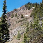
- a on way to Edgar Rock

-
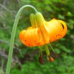
- e tiger lily

-
- c up

Hike to a historic rock through a lush, Ponderosa forest. Gaze at views overlooking the Nile Valley and the American River. Choose this day hike just east of Mt. Rainier National Park, and you’re likely to have it all to yourself.
Finding the trailhead to Edgar Rock is a little challenging but worth the effort. The “trailhead” is a wide spot on a narrow, forest service road with limited parking and the sign for Lost Creek almost “lost” in shrubbery near the trailhead. Once you find the trailhead, go right (uphill). The hike begins on the Lost Creek Trail No. 964 – only the last stretch of the hike is designated as the Edgar Rock Trail No. 964A.
How did Edgar Rock get its name?
Edgar Rock is part of an ancient Miocene volcano and serves as a landmark near the community of Cliffdell on State Route 410. The rock was named for John Edgar, an Army Scout killed in the 1850s during the Indian Wars.
The trail starts off climbing through grassy, Ponderosa forest and is in good condition. Near the trailhead look for American Pinesap and ghostly Indian Pipe often spotted in the duff near Douglas fir trees.
As the trail gradually climbs out of the forest you’ll pass a few bluebird boxes and “heritage” trees along the trail. Heritage trees are specifically left in place for wildlife habitat. In summer, wildflower displays light up the landscape with swatches of color ranging from the peacock blue of Larkspur to the dusky pink of Nootka roses. Yellow composites (too many to name) are scattered across the landscape like gold doubloons. In June, balsamroot was just about ready to close up shop for the year but other flowers are just getting into the groove. We saw buckwheat, yarrow, pinedrops, Indian paintbrush, Hooker’s onion, Nootka rose, and a variety of penstemon and bluebells.
Ponderosa pines seem to hold switchbacks in place as the forest opens up to better views of surrounding ridges and rock formations. About a mile up the trail you’ll come across an odd relationship between boulders and a tree. Watch for two boulders holding a tree in place at the edge of the trail – or perhaps it is the tree is holding the boulders in place (it’s hard to tell).
This trail is not as well-known to hikers as other trails in the region so you might have it to yourself. Though the trail is also open to mountain bikes, motorcycles and stock (closed to ATVs) we’ve never encountered anyone else on this trail. According to the Naches District trail guide, only the last 1/3 mile of the trail is designated as the Edgar Rock trail (Trail No. 964A) though that junction wasn’t signed when we hiked there recently (the junction is obvious).
The country is open and invites further exploration – we explored a side trail that led to a rocky area with numerous wildflower displays. The geology is such that the word “moonscape” comes to mind. We even found a small, natural arch (west of Edgar Rock) on another side-trail.
This is thunderstorm country – even when cool and overcast, the air can grow thick with humidity. Be cautious when the sky darkens and thunder rumbles, especially near the summit where the trail is exposed as it winds between boulders, weathered snags, and outcroppings. Though the day was cloudy, the humidity was high and we felt sluggish on the “ups.”
Directions to Edgar Rock
Getting there: From Chinook Pass drive east on SR 410 to River Road (No. 1706) and turn right to cross Naches River. At Road No. 1704 turn left, continue past private cabins and residences to Spur Road 311 to the Lost Creek trailhead (Trail No. 964). Park on the shoulder of road (no facilities). Display your Northwest Forest Pass and keep party size small, parking is limited. Map: Green Trails Old Scab Mountain No. 272. For additional information contact the Naches Ranger District (Okanogan-Wenatchee Forest) at 509-653-1401.
– Karen Sykes, Visit Rainier Hiking Expert
Waypoints
| Starting Point: 46.91977, -121.05586 | |
| Notable Waypoints:
Lost Creek Trailhead: N 46° 55′ 11, W 121° 03′ 21 |
|