| Area: Greenwater |
Hike Type: Dog-friendly | Pass: Northwest Forest Pass |
| Distance: 14.08 mi RT | Duration: 6-7 hrs | Difficulty Level: Moderate |
| Elevation Start: 1,191 | Elevation End: 4,091 | Elevation Gain: 2,900 |
| Snow-Free: July – Sept |
-
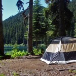
- Campsite Echo Lake

Travel a deeply forested river valley, passing cool Greenwater Lake to the more remote Echo Lake where hikers can expect a setting of solitude and beauty. The hike is a long seven miles, but times goes by quickly as you walk the pretty and duff-rich trail. The hike is especially recommended on a hot day as much of the trail lies within the forest. The trail to Echo Lake never strays far from the Greenwater River as the trail climbs through the trees, often within sight and sound of the river.
Get an early start for more solitude on the trail, as this hike starts out on the popular Greenwater Lakes trail. Expect to meet a few backpackers and hardy day-hikers coming and going.
The first 2.2-miles of the hike along the Greenwater Lakes trail is the “busiest” section of trail as it is scenic and ideal for beginning hikers, backpackers, and families with small children. The trail crosses the Greenwater River a half-dozen times on robust bridges, all with railings. There are horse fords for those who prefer to ride.
Notice the fine line between the Greenwater River and the lakes. The Greenwater River flows through the lakes – below upper Greenwater Lake, the river spreads out and makes a great imitation of a lake in a couple of spots before it turns back into a river again. Boot paths lead to closer views. The setting is poetic with plumes of campfire smoke (or mist) rising from the lakeshore and the green, luminous lakes. In summer, lacy saxifrages embrace rock outcroppings above the water. As the trail approaches the last major crossing of the Greenwater River along a double bridge, yellow monkey-flowers border the trail.
After crossing the river on the bridge, the trail reaches a signed junction (3.1 miles from the trailhead) for Lost Lake and Echo Lake. The Lost Lake trail continues straight. Turn left at the junction for Echo Lake and the Maggie Creek Trail; they begin as one.
In late July there were still a few flowers – columbine, yellow violet, Canadian dogwood (bunchberry), coralroot orchid, wild strawberries, and thimbleberry. We were grateful for the occasional cool breeze that wafted through the trees giving relief from the heat of the day.
The trail is in good condition with only a couple of muddy spots that can be avoided with skill and grace. Fallen trees are studded with shelf-fungus and nurse-logs host seedlings seeking light. Stumps are topped with miniature gardens of moss, lichen, seedlings, salal and huckleberry shrubs. Shade-loving ferns border the trail, especially deer fern and oak fern.
In about 5.6 miles from the trailhead, we reached the (signed) junction with the Maggie Creek trail. The Maggie Creek trail climbs to the Pacific Crest Trail No. 2000 in 5 miles and more possibilities for backpackers (they can include a side-trip to Arch Rock, not far off the Pacific Crest Trail). Note that hiking to Arch Rock from Echo Lake is only recommended for strong, experienced hikers with route-finding skills (to get to Arch Rock hikers need to ford the Greenwater River – there is no bridge and trails above Echo Lake are sketchy). Study the map for details.
We continued to Echo Lake after pausing at the Maggie Creek junction (N 47° 03′ 17″, W 121° 25′ 06″) for food and water before tackling the final stretch of the trail. The last stretch passes a pond and climbs to a high point (4,091 feet) before making a short, steep descent to Echo Lake. You’ll see the lake through the trees.
A little above the lakeshore you’ll reach a signed junction where you’ll need to make a decision. The closest camp (with toilet) is to the left. The right fork continues to a designated horse-camp and additional campsites. We’d planned to visit the horse-camp first but turned around when we came to a stream that looked easier for horses to cross than us (crossing it shouldn’t be a problem in a week or two – it’s only a rock hop).
Echo Lake was larger than we anticipated, the lakeshore fringed with willows, serviceberry and salal with campsites where hikers and campers can access the lake to swim, fish, cool their feet, or just hang out. The best campsite, in my opinion, is the first one – don’t be surprised to find it occupied.
Can you camp at Echo Lake?
Yes, campsites at the lake are first-come, first-serve, some more primitive than others. If you venture beyond the campsites you might give pause when you run into the Greenwater River (remember, the river flows through Echo Lake). We glimpsed a campsite on the other side but you’d have to cross the river on a sketchy, knobby log. We made the river our turnaround, a pretty spot to stop for lunch with views of the lake, the river, minor peaks, and ridges.
You might not look forward to the climb out from the lake after a lazy lunch, but it is mercifully short – plus, most of the way back to the Greenwater Lakes trailhead is downhill and easy-going.
Be sure to carry plenty of water; carry water-treatment tablets or filter as needed (there are water-sources along the trail). We took a cool, delicious, water-break at the Lost Lake/Echo Lake junction, filled our water bottles from the river and treated accordingly. Even though we’d carried plenty of water that wasn’t enough to get us back to the trailhead on such a hot day.
By the time we hiked back to Greenwater Lakes, several camps had been established beside the lakes, and day hikers, including happy teens cradling ice chests, were arriving in full-force for a lazy, summer evening.
How to find the trailhead at Echo Lake
From Enumclaw, head east on SR 410 and turn left off onto paved Forest Service Road No. 70. Forest Service Road No. 70 is about 1.5 miles past Greenwater. In a little under 10 miles, look for a short, gravel spur (right) and trailhead sign that leads to trailhead parking and trailhead. A Northwest Forest Pass is required. The maps are Green Trails No. 238 Greenwater and No. 239 Lester.
Who to contact for more info?
For additional information (including camping in the Norse Peak Wilderness), contact the Mount-Baker-Snoqualmie National Forest (Enumclaw district) at 360-825-6585.
– Karen Sykes, Visit Rainier Hiking Expert”
Waypoints
| Starting Point: 47.10594337751885, -121.47514495239261 | |
| Notable Waypoints:
Trailhead: N 47° 06′ 21, W 121° 28′ 31 |
|