| Area: Chinook Pass |
Hike Type: Mountain views | Pass: National Park Pass |
| Distance: 7.8 mi RT | Duration: 6 hrs | Difficulty Level: Difficult |
| Snow-Free: late-June – Oct | High Point: 6,595 ft | Elevation Gain: 3,400 ft |
-
- IMG 3478

-
- IMG 3512 Copy

-
- IMG 3540

-
- IMG 3498
-
- IMG 3510 Copy 1

-
- IMG 3447 3

-
- IMG 3500
-

- IMG 3516

Features: exemplary wildflowers, sweeping views, historic fire lookout site
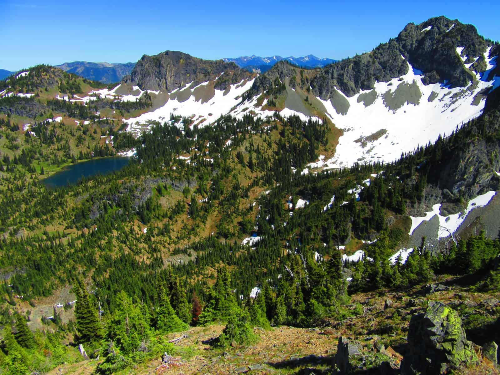
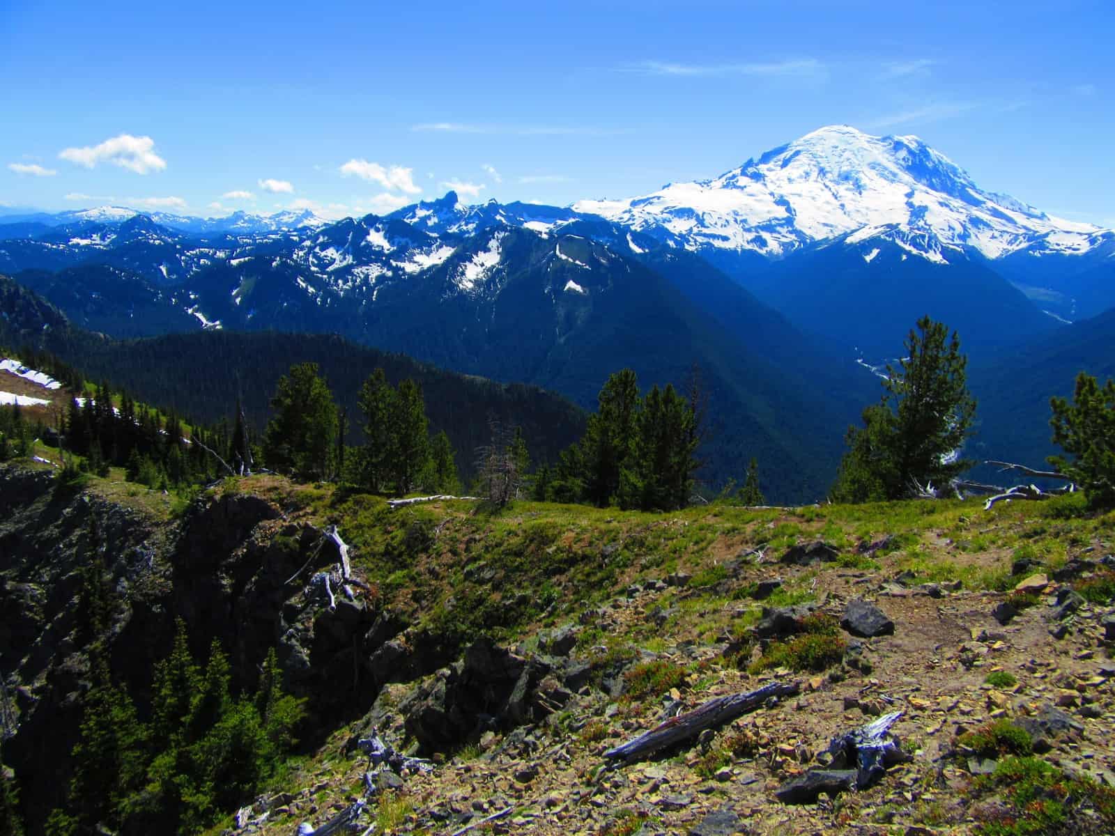
Stand atop this thumb of a peak and prepare to be visually blown away. Stare straight down at the White River parting a sea of verdant high peaks lapping up against the glacier-crowned Rainier. Then look across the deep glacier-trenched White River Valley to the serrated Sourdough Mountains. Cast your attention northward to the Palisades—and eastward to a high open basin cradling a sparkling alpine lake. It’s easy to see why Crystal Peak was chosen as a lookout site. The fire lookout however is long gone, but the views are as hot as ever.
Hit the Trail:
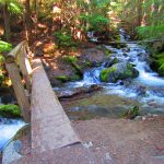
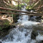
Don’t let a crowded parking lot discourage you. Most of those vehicles belong to hikers heading to the popular Crystal Lakes. You’ll be sharing some tread with them in the beginning—but then will be setting off on a much less traveled route. The way enters cool forest and immediately crosses via log-bridge cascading Crystal Creek. Now waste no time climbing. The steepest and most difficult part of this hike is the first mile. Via switchbacks, the way relentlessly climbs.
As you huff and puff up the steep slopes, notice how dry the forest is here. You are in the Mount Rainier rainshadow. The mountain catches and blocks many rain clouds here creating a micro-climate quite different than the saturated one due west in the Carbon River Valley. Notice too, the young hemlocks. Much of the surrounding slopes succumbed to forest fires in the early 20th Century. You’ll pass through a few stands of older firs along the way, but much of the forest is quite young.
While the forest is dry, the surrounding slopes are graced with numerous tumbling creeks. Crystal Creek remains just out-of-sight tucked in a narrow ravine. Its crashing however makes you well aware of its presence. You’ll pass a few glimpses of Rainier too on the way—just little teasers of what awaits. At about 1.0 mile the way finally eases up. Notice too, the forest floor—now much greener carpeted with vanilla leaf and other small plants.
At 1.3 miles reach a signed junction. Here the much more popular Crystal Lakes Trail continues left. You want to go right. After the fire lookout was removed from Crystal Peak back in the 1970s, the park service officially abandoned this trail. But its stellar views and gentle grade couldn’t keep hikers from continuing to use this trail—in my opinion one of the best in the park. Eventually volunteers and park service began once again maintaining this route. Good thing too—for soon you reach Crystal Creek—and now a sturdy bridge replaces a boot soaking crossing.
Once across the creek, pass one lone gigantic Douglas Fr. Then begin one long sweeping switchback gaining elevation at an agreeable pace. Cross a scree slope providing a decent view down the White River Valley and soon return to forest cover. That won’t last for long as the way eventually emerges in brushy avy slopes—then wide open meadows punctuated with subalpine firs, whitebark pines—and a few silver snags standing testament to the past fires.
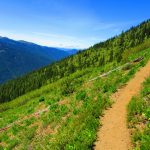
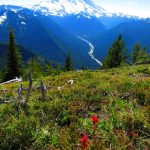
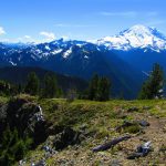
The way continues traversing open slopes. Hulking Rainier is now in your face. On a sunny day its icy façade can be blinding. The massive mountain hovers over the deeply trenched White River Valley. The glacier-born river snakes down the valley and glistens in the afternoon sun. If you can pull your attention away from the mountain and the river, look down. A mosaic of wildflowers are blossoming at your feet. Lupine, paintbrush, penstemon, stonecrop, phlox, tiger lilies and more have set these slopes awash in brilliant colors. Come in late summer and the trail is lined with blueberries and huckleberries giving you yet another reason to look down and slow down.
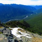
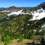
After about 1.7 miles the trail finally switches back. Here at about 5,800 feet see if you can locate the Deadwood Lakes in a basin just to the south. When the sun is out, you can usually see them twinkling in the hidden cirque. Now hike south gaining elevation at a better clip. Roll along the contours of the open slopes gazing out at a beautiful alpine world before you. The trail makes two short switchbacks before coming to the old lookout site on the edge of some steep ledges. Noting remains of it but some concrete bases. Look north over the Crystal Creek valley to Crystal Mountain and its many summits. Look down the White River Valley too picking out the prominent Palisades and Sun Top Lookout.
You can continue just a little farther to Crystal Peak’s summit by following a steep path along the cliff edges. At 3.8 miles attain the 6595-foot summit. Yep—the views just got better. Look south over the shoulder of Chinook Peak and see snowy Mount Adams—Rainier’s shorter twin. Now look a little to the west and see Mount Hood. Keep looking west and pick out St Helens hovering over the Tatoosh Range.
Look east over the big open basin cradling the upper Crystal Lake. See anyone hiking or camping below? And beyond the craggy peaks hemming in the lake, you can make out parts of the rugged American and Nelson ridges. It all makes for a stunning view!
Notes: Dogs-prohibited, exercise caution near summit cliffs.
Contact: Mount Rainier National Park; https://www.nps.gov/mora/index.htm; (360) 569-2211
Maps: Green Trails Mount Rainier National Park 269S
Trailhead directions: From Enumclaw follow SR 410 for 36.5 miles to trailhead (about 0.5 mile before Sunrise Road turnoff) located on your left. Parking available either side of road—use caution crossing the busy highway.
Trailhead facilities: None; find water and restrooms at nearby Wilderness Information Center on Sunrise Road.
– Craig Romano, is an author of more than a dozen hiking guidebooks including the newly released 100 Classic Hikes Washington (Mountaineers Books) which includes several hikes in and around Mount Rainier National Park.
Waypoints
| Starting Point: N46 55.364 W121 32.022 | |
| Notable Waypoints:
Crystal Peak Trail junction: N46 55.150 W121 31.316 Crystal Peak summit: N46 54.367 W121 31.140 |
|